In geology, a fault is a planar fracture or discontinuity in a volume of rock, across which there has been significant displacement as a result of rock-mass movement. Large faults within the Earth's crust result from the action of plate tectonic forces, with the largest forming the boundaries between the plates, such as subduction zones or transform faults. Energy release associated with rapid movement on active faults is the cause of most earthquakes.

The Niger Delta Basin, also referred to as the Niger Delta province, is an extensional rift basin located in the Niger Delta and the Gulf of Guinea on the passive continental margin near the western coast of Nigeria with suspected or proven access to Cameroon, Equatorial Guinea and São Tomé and Príncipe. This basin is very complex, and it carries high economic value as it contains a very productive petroleum system. The Niger delta basin is one of the largest subaerial basins in Africa. It has a subaerial area of about 75,000 km2, a total area of 300,000 km2, and a sediment fill of 500,000 km3. The sediment fill has a depth between 9–12 km. It is composed of several different geologic formations that indicate how this basin could have formed, as well as the regional and large scale tectonics of the area. The Niger Delta Basin is an extensional basin surrounded by many other basins in the area that all formed from similar processes. The Niger Delta Basin lies in the south westernmost part of a larger tectonic structure, the Benue Trough. The other side of the basin is bounded by the Cameroon Volcanic Line and the transform passive continental margin.

The North American Plate is a tectonic plate covering most of North America, Greenland, Cuba, the Bahamas, extreme northeastern Asia, and parts of Iceland and the Azores. It extends eastward to the Mid-Atlantic Ridge and westward to the Chersky Range in eastern Siberia. The plate includes both continental and oceanic crust. The interior of the main continental landmass includes an extensive granitic core called a craton. Along most of the edges of this craton are fragments of crustal material called terranes, accreted to the craton by tectonic actions over a long span of time. It is thought that much of North America west of the Rocky Mountains is composed of such terranes.

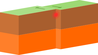
In geology, a graben is a depressed block of the crust of a planet bordered by parallel faults.

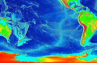
In geology, a rift is a linear zone where the lithosphere is being pulled apart and is an example of extensional tectonics.

The Sevier orogeny was a mountain-building event that affected western North America from Canada to the north to Mexico to the south.

Basin and range topography is an alternating landscape of parallel mountain ranges and valleys. It is a result of crustal extension/stretching of the lithosphere due to mantle upwelling, gravitational collapse, crustal thickening, or relaxation of confining stresses. Crustal extension causes the thinning and deformation of the upper crust in an orientation perpendicular to the direction of extension. As the plates pull apart, they thin allowing the hot mantle to rise close to the surface. When the crust is extended it fractures along a fault plane, creating a series of long parallel normal faults. Between these normal faults are blocks, which subside, get uplifted or tilted. This is known as block faulting. Basins are formed due to subsidence of a block, while the blocks adjacent to the subsidence gets uplifted creating ranges. Normal faults are on both sides the blocks; creating alternating elevated or subsided blocks, otherwise known as horst and graben. Basins and ranges can also be formed by blocks that are tilted causing one side to subside while the other side gets uplifted. These only have one side with a normal fault, this is known as tilted block faulting. Extension causes the plate to stretch, fracture and thin. Mountains rise and valleys drop, over a long period of time creating what we see as basin and range topography.

The Promontory Mountains are a range in Box Elder County, Utah. The range is oriented north-south and has a length of about 35 miles (56 km). The southern portion forms a cape extending 20 miles (32 km) south into the Great Salt Lake. The First Transcontinental Railroad was completed with the Golden Spike just north of the range at Promontory Summit in the Utah Territory. Today, trains cross the Promontory Point at the southern tip of the range via the Lucin Cutoff railroad causeway across the lake.
The Brawley Seismic Zone (BSZ), also known as the Brawley fault zone, is a predominantly extensional tectonic zone that connects the southern terminus of the San Andreas Fault with the Imperial Fault in Southern California. The BSZ is named for the nearby town of Brawley in Imperial County, California, and the seismicity there is characterized by earthquake swarms.
The Cerro Prieto Fault is a transform fault located in far northern Baja California. It runs between the Cerro Prieto spreading center located southwest of Mexicali, and the Wagner Basin, another spreading center which lies under the Gulf of California. These spreading centers are part of the East Pacific Rise, the northern leg of which has formed the Gulf of California by steadily rifting the Baja California Peninsula away from the mainland of Mexico.
The Guaymas Fault, named for the city of Guaymas, Sonora, Mexico, is a major right lateral-moving transform fault which runs along the seabed of the Gulf of California. It is an integral part of the Gulf of California Rift Zone, the northern extremity of the East Pacific Rise. The Guaymas Fault runs from the San Pedro Martir Basin located at the southern end of the San Lorenzo Fault, and extends southward to the Guaymas Basin, a heavily sedimented rift which includes both continental and oceanic crust and contains numerous hydrothermal vents.
The Gulf of California Rift Zone (GCRZ) is the northernmost extension of the East Pacific Rise which extends some 1,300 km (800 mi) from the mouth of the Gulf of California to the southern terminus of the San Andreas Fault at the Salton Sink.
The Alarcon Basin is a submarine depression located on the seabed at the southern end of the Gulf of California. The basin results from the activity of the southernmost spreading center in the Gulf. This spreading center has also produced the southernmost oceanic rift in the Gulf of California Rift Zone, the Alarcon Rise. The basin and rise are linked to the Tamayo Fault to the south, and the Pescadero Fault in the north.

The Atacama Fault Zone (AFZ) is an extensive system of faults cutting across the Chilean Coastal Cordillera in Northern Chile between the Andean Mountain range and the Pacific Ocean. The fault system is North-South striking and runs for more than 1100 km North and up to 50 km in width through the Andean forearc region. The zone is a direct result of the ongoing subduction of the Eastward moving Nazca Plate beneath the South American Plate and is believed to have formed in the Early Jurassic during the beginnings of the Andean orogeny. The zone can be split into 3 regions: the North, Central and South.
A half-graben is a geological structure bounded by a fault along one side of its boundaries, unlike a full graben where a depressed block of land is bordered by parallel faults.
A transfer zone in geology is an area where deformational strain is transferred from one structural element to another typically from fault to fault in rift systems. Therefore, listric faults and monoclinal folds in the hanging wall are typical structures linked by transfer zones; however, complexities do exist. The terms interbasin and intrabasin transfer zones have been proposed to delineate the magnitude of the transfer zone. Transfer zones can be described according to the fault dip directions; synthetic or conjugate and according to their deformation style; convergent or divergent. Transfer zones can be farther identified by its maturity or ; whether the major fault relationship is approaching, overlapping, collateral or collinear. Since transfer zones are normally found in extensional settings many studies have been done within the East African rift system and the Gulf of Suez rift system. Transfer zones have also played a role in hydrocarbon exploration and extraction within the Albertine graben.

The Gulf of Corinth is an active extensional marine sedimentary basin thought to have started deforming during the late Miocene – Pleistocene epoch. The dimensions of the Gulf of Corinth are approximately 105 km long and 30 km wide with a basement depth of 3 km at its center. This half-graben basin is formed by a N100°E-oriented rift which separates the Peloponnese peninsula from the continental mainland of Greece. Currently the Gulf's rift is opening at rate of 10–15 mm/yr, with respect to the Eurasia Plate. The basin is bounded by the Peloponnese highlands to the south and the westward-moving Anatolian Fault to the north. Major and minor fault planes make up the north and south margins, and its north-south extension is due to activity along a E-W to NW-SE oriented coastal southern margin. The basin's active and inactive faults create associated syn-rift sediment fill. These aspects provide a unique opportunity for scientists to study the tectonic and stratigraphic development of a rift, while further understanding how a basin is actually made.

The Woodlark Basin is a geologic structural basin located in the southwestern Pacific Ocean and can be found to the southwest of the island country of Papua New Guinea. The basin is an extensional basin that is actively spreading and has a seafloor spreading center. This basin lies between the Indo-Australian Plate and the Solomon microplate and is located at 09°S, 155°E. The Woodlark Basin has an interesting geologic history dating back twenty million years to the initial opening of the basin; the spreading of the basin, however, has occurred within the past three million years. Due to the relatively young age of the basin, many researchers are interested in learning how the basin will continue to develop over time and how the plates will subduct. The subduction of the plates in the Woodlark Basin will be unique because the new crust being formed will be young and warm unlike most crust that gets subducted due to its low temperature and high density.