Related Research Articles

Coos County is one of the 36 counties in the U.S. state of Oregon. As of the 2020 census, the population was 64,929. The county seat is Coquille. The county was formed from the western parts of Umpqua and Jackson counties. It is named after a tribe of Native Americans who live in the region. Coos County comprises the Coos Bay, OR Micropolitan Statistical Area.
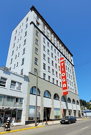
Coos Bay is a city located in Coos County, Oregon, United States, where the Coos River enters Coos Bay on the Pacific Ocean. The city borders the city of North Bend, and together they are often referred to as one entity called either Coos Bay-North Bend or Oregon's Bay Area. Coos Bay's population as of the 2020 census was 15,985 residents, making it the most populous city on the Oregon Coast. Oregon's Bay Area is estimated to be home to 32,308.

Reedsport is a city in northwest Douglas County, Oregon, United States. As of the 2020 census, the population was 4,310.

The United States Coast Guard Aids To Navigation Team, ANT Coos Bay was established in 1976 and is located near the mouth of Coos Bay in the fishing and tourist community of Charleston, Oregon, southwest of the city of Coos Bay. ANT Coos Bay's area of responsibility ranges over 240 miles of the Oregon coast and includes 3 lighthouses, 18 primary buoys, 43 secondary buoys and 156 other lights, day beacons and fog signals.

South Slough National Estuarine Research Reserve (SSNERR) is a 4,770-acre (19 km2) National Estuarine Research Reserve located on Coos Bay Estuary, in the U.S. state of Oregon. Its headquarters are in Charleston. Established in 1974, it was the first reserve in the United States created in response to the federal Coastal Zone Management Act of 1972.

The Oregon Institute of Marine Biology is the marine station of the University of Oregon. This 100-acre (0.40 km2) marine station is located in Charleston, Oregon at the mouth of Coos Bay. Currently, OIMB is home to several permanent faculty members and a number of graduate students. OIMB is a member of the National Association of Marine Laboratories (NAML). In addition to graduate research, undergraduate classes are offered year round, including marine birds and mammals, estuarine biology, marine ecology, invertebrate zoology, molecular biology, biology of fishes, biological oceanography, and embryology.

The history of steamboats on the Oregon Coast begins in the late 19th century. Before the development of modern road and rail networks, transportation on the coast of Oregon was largely water-borne. This article focuses on inland steamboats and similar craft operating in, from south to north on the coast: Rogue River, Coquille River, Coos Bay, Umpqua River, Siuslaw Bay, Yaquina Bay, Siletz River, and Tillamook Bay. The boats were all very small, nothing like the big sternwheelers and propeller boats that ran on the Columbia River or Puget Sound. There were many of them, however, and they came to be known as the "mosquito fleet."
Tourtellotte & Hummel was an American architectural firm from Boise, Idaho and Portland, Oregon.
Tiernan is an unincorporated community in Lane County, Oregon, United States. It is about five miles west of Mapleton on Oregon Route 126 near the Siuslaw River and within the Siuslaw National Forest.
Siltcoos is an unincorporated community in Lane County, Oregon, United States. It is about 13 miles (21 km) south of Florence on the east shore of Siltcoos Lake.
North Bend Air Force Station is a closed United States Air Force General Surveillance Radar station. It is located 3.9 miles (6.3 km) north-northeast of Hauser, Oregon. It was closed in 1980.
Cooston is an unincorporated community in Coos County, Oregon, United States. It is located on the east shore of Coos Bay across from North Bend, about eight miles from the city of Coos Bay.
Camp Castaway was a military encampment at what is now Coos Bay, Oregon, United States. It was established by the survivors of the wreck of the Captain Lincoln, a U.S. transport schooner, on January 3, 1852. The ship began taking on water during a storm while en route from San Francisco to Fort Orford at the town of Port Orford. To avoid sinking, the captain decided to beach the ship north of Cape Arago. All of the roughly 30 troops on board, and the ship's crew, survived the wreck and most of the cargo was salvaged. At the time no U.S. settlement was present at Coos Bay, so commanding officer Lt. Henry Stanton decided to establish the camp to protect the cargo until it could be transported to Fort Orford, some 50 miles south on the Oregon Coast. The troops and crew used spars, booms and sail cloth from the schooner to build tent structures for housing and for protecting the cargo from winter rains and blowing sand. They named the temporary post Camp Castaway. The camp endured for four months in the open dunes with help from Native Americans of the Coos tribe who traded fresh foods to the soldiers for silverware, biscuits and other nonlocal goods.
Beaver Hill is an unincorporated community in Coos County, Oregon, United States. It is about 12 miles (19 km) south of the city of Coos Bay, east of U.S. Route 101 and west of Oregon Route 42.

Haynes Inlet is a bay located in North Bend, Coos County.
Jarvis Landing was a landing place on the north side of the entrance to Coos Bay in Oregon, United States.
Lighthouse Beach is a beach in Coos County, Oregon, United States. It is located between Yoakam Point State Natural Site to the north and Cape Arago Lighthouse to the south, in the unincorporated community of Charleston.
Grandma Tree is a record setting Douglas fir in Oregon. The tree sits near North Fork Coquille River in Coos County. The tree's girth of c. 10 metres (33 ft) is the second greatest of a living Douglas fir in the United States.
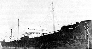
SS Camden was an American 6,653-ton tanker built by the New York Shipbuilding Company of Camden, New Jersey, for the Charles Kurz & Co. Inc. of Pennsylvania Shipping Company. She was operated by Shell Oil Company of Wilmington, Delaware. She was launched in 1921. The ship became famous when it was torpedoed early in World War II off the West Coast of the United States off Coos Bay, Oregon, at 43.38 N, –124.48 W at 7:00 am. She had departed San Pedro, Los Angeles, California, to Portland, Oregon, with fuel oil. The ship was attacked by Japanese submarine I-25 on October 4, 1942 off Oregon. She had been stopped for engine repairs at the time of the attack. She survived the attack, but later sank on October 10. One Crew member died and went down with the ship. The Camden was set on fire by the torpedo hit to her bow and was sinking. The crew abandoned ship and was rescued by a Swedish merchant ship, the MV Kookaburra. The Camden still on fire remained afloat. The tugboat Kenai was towing her to Astoria, Oregon, but then changed the path to Seattle, but the Camden sank off the coast of Washington state at 46.7772, -124.5208 and now rests at a depth of 312 feet.
Canary is an unincorporated community in Lane County, Oregon, United States.
References
- ↑ "New Postoffice in Use". The Oregonian . November 24, 1936. p. 15.