
The Arctic Archipelago, also known as the Canadian Arctic Archipelago, is an archipelago lying to the north of the Canadian continental mainland, excluding Greenland and Iceland.

Booth Island is a Y-shaped island, 5 nautical miles long and rising to 980 metres (3,220 ft) in the northeast part of the Wilhelm Archipelago, Antarctica.

Shackleton Glacier is a major Antarctic glacier, over 60 nautical miles long and from 5 to 10 nautical miles wide, descending from the Antarctic Plateau from the vicinity of Roberts Massif and flowing north through the Queen Maud Mountains to enter the Ross Ice Shelf between Mount Speed and Waldron Spurs. Discovered by the United States Antarctic Service (USAS) (1939–41) and named by the Advisory Committee on Antarctic Names (US-ACAN) for Sir Ernest Shackleton, British Antarctic explorer.
The Prince Olav Mountains is a mountain group in the Queen Maud Mountains in Antarctica stretching from Shackleton Glacier to Liv Glacier at the head of the Ross Ice Shelf.

The Priestley Glacier is a major valley glacier, about 60 nautical miles long, originating at the edge of the Polar Plateau of Victoria Land, Antarctica. The glacier drains southeast between the Deep Freeze Range and Eisenhower Range to enter the northern end of the Nansen Ice Sheet. It was first explored by the Northern Party of the British Antarctic Expedition, 1910–13, and named for Raymond Priestley, a geologist with the Northern Party.

The Prince Charles Mountains are a major group of mountains in Mac. Robertson Land in Antarctica, including the Athos Range, the Porthos Range, and the Aramis Range. The highest peak is Mount Menzies, with a height of 3,228 m (10,591 ft). Other prominent peaks are Mount Izabelle and Mount Stinear. These mountains, together with other scattered peaks, form an arc about 420 km (260 mi) long, extending from the vicinity of Mount Starlight in the north to Goodspeed Nunataks in the south.

The Erebus and Terror Gulf is a gulf on the southeast side of the tip of the Antarctic Peninsula, bordered on the northeast by the Joinville Island group and on the southwest by the James Ross Island group.
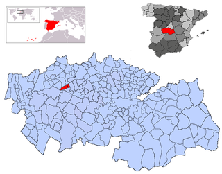
Cazalegas is a municipality located in the west of province of Toledo, Castile-La Mancha, Spain. According to the 2006 census (INE), the municipality has a population of 1561 inhabitants.

Villamartín de Campos is a municipality in the province of Palencia, Castile and León, Spain. According to the 2004 census (INE), the municipality has a population of 134.

Flandres Bay is a large bay lying between Cape Renard and Cape Willems, along the west coast of Graham Land, Antarctica.

Oaky River, a perennial stream of the Macleay River catchment, is located in the Northern Tablelands district of New South Wales, Australia.
The Land Glacier is a broad, heavily crevassed glacier, about 35 nautical miles long, descending into Land Bay in Marie Byrd Land, Antarctica. It was discovered by the United States Antarctic Service (1939–41) and named for Rear Admiral Emory S. Land, Chairman of the United States Maritime Commission.
Võhmanõmme is a village in Põltsamaa Parish, Jõgeva County in eastern Estonia.

Bilgeri Glacier is a glacier flowing into Barilari Bay south of Huitfeldt Point and west of Byaga Point, on Velingrad Peninsula on the west coast of Graham Land in Antarctica. It was charted by the British Graham Land Expedition under John Rymill, 1934–37, and named by the UK Antarctic Place-Names Committee in 1959 for Georg Bilgeri (1873–1934), Austrian pioneer exponent of skiing, inventor of the first spring ski binding, and author of one of the earliest skiing manuals.

Bussey Glacier is a glacier flowing west from Mount Peary to the head of Waddington Bay on Kyiv Peninsula on the west coast of Graham Land. It was first charted by the French Antarctic Expedition under Jean-Baptiste Charcot, 1908–10, and named by the UK Antarctic Place-Names Committee in 1959 for Group Captain John Bussey of the Directorate of Overseas Surveys.
Plata Passage or Admiral Merino Channel is a passage in Wilhelmina Bay separating Brooklyn Island from the west coast of Graham Land. First charted by the Belgian Antarctic Expedition under Gerlache, 1897–99, and named after the estuary between Argentina and Uruguay in recognition of the services rendered the expedition by the people of Argentina.
Ford Massif is a broad, snow-topped massif 15 nautical miles long and 5 nautical miles wide, forming the major topographic landmark of the northern Thiel Mountains in Antarctica. The massif rises to 2,810 metres (9,220 ft), is essentially flat, and terminates in steep rock cliffs in all but the southern side.
Renard Glacier is a glacier flowing into the southernmost part of Charlotte Bay, on the west coast of Graham Land. Charted by the Belgian Antarctic Expedition under Gerlache, 1897–99. Named by the United Kingdom Antarctic Place-Names Committee (UK-APC) in 1960 for Charles Renard (1847–1905), who, with A.C. Krebs, constructed and flew the first dirigible airship capable of steady flight under control, in 1884.
Vicungo is a town and commune of Angola, located in the province of Huíla.