
Leeton is a town located in the Riverina region of southern New South Wales, Australia. Situated approximately 550 km west of Sydney and 450 km north of Melbourne in the Murrumbidgee Irrigation Area, it is the administrative centre of the Leeton Shire Council local government area. Leeton's urban population in 2016 was 8,623. Situated in one of the most productive farming regions in the state, the town was designed by Walter Burley Griffin and purpose-built for the irrigation schemes announced by the New South Wales government in the early 1900s. Citrus, rice, cotton, grapes, walnuts and wheat farms can all be found throughout the Leeton Shire. Leeton is renowned as Australia's Rice Capital and as The Heart of SunRice Country, as it is home to the SunRice headquarters. Other industry includes Freedom Foods, the Daily Drinks Co., JBS Australia, Webster Limited and Murrumbidgee Irrigation Limited.

Leeton Shire is a local government area in the Riverina region of New South Wales, Australia. The Shire is located adjacent to the Murrumbidgee River and falls within the Murrumbidgee Irrigation Area.

Belgica Mountains is an isolated chain of mountains about 10 miles (16 km) long, standing 60 miles (97 km) east-southeast of the Sor Rondane Mountains in Queen Maud Land, in the Antarctic. The chain was discovered by the Belgian Antarctic Expedition (1957-1958) under Gaston de Gerlache, and named after the ship Belgica, commanded by his father, Lt. Adrien de Gerlache, leader of the Belgian Antarctic Expedition of 1897-99. The Prince de Ligne Mountains stand about 10 mi (16 km) north of the Belgica Mountains.
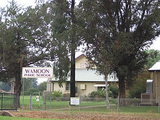
Wamoon is a village in Leeton Shire in the Riverina region of New South Wales, Australia. Wamoon is located 8.8 kilometres (5.5 mi) from Leeton along the Irrigation Way to the Leeton CBD and Henry Lawson Drive to the Leeton suburb of Wattle Hill. Wamoon provides a village of homes to the farmers of northern Leeton and there is a small primary school known as Wamoon Public School.

The Murrumbidgee Irrigation Area (MIA) is geographically located within the Riverina area of New South Wales. It was created to control and divert the flow of local river and creek systems for the purpose of food production. The main river systems feeding and fed by the area are the Murrumbidgee and the Tumut. It is one of the most diverse and productive regions in Australia contributing over A$5 billion annually to the Australian economy.
Wattle Hill is a north-western suburb of Leeton, New South Wales. Wattle Hill was developed in the 1970s and 80's as a joint venture between Leeton Shire Council and the New South Wales Department of Housing. Wattle Hill has a large concentration of housing department homes particularly on Gossamer, Wirilda and Blackwood Streets. The rest of the suburb has private residences, a small shopping precinct and three parks, one of which has a large water tower that supplies water to Wattle Hill and Wamoon. During the development of Wattle Hill, it was proposed that a state primary school was to be built in the suburb with land set aside to the west of the suburb, however, the school was built in the nearby suburb of Parkview. Prior to redevelopment, Wattle Hill was an unofficial low-income housing area for many local families. There were many homes there without floors, constructed from poles, flattened 4-gallon drums and hessian.
Parkview is a residential suburb of Leeton, New South Wales in Leeton Shire. Parkview is located to the south west of town, and can be accessed via the Oak Street Bridge. Parkview is home to Leeton's second state school, Parkview Public School, a small shop and butcher, two churches, and an array of sporting facilities such as tennis and basketball courts. Leeton's showground, racecourse and the MIA Sports Club are located to the east of the suburb across the railway track.
Wiradjuri is a subdivision in the rapidly growing Northern area of Leeton, New South Wales in Leeton Shire. Wiradjuri was developed in the 1980s and 90s to cope with Leeton's housing shortage and population boom. The Leeton High School sporting ovals are located to the east.

Gralee is a suburb of Leeton, New South Wales in Leeton Shire. Gralee facilities include:

Willimbong is a suburb of Leeton, New South Wales, Australia in Leeton Shire. Willimbong has a mix of industrial and residential properties. Leeton's SunRice and Coprice Mills are located in Willimbong as well as the Berri Juice Factory, MIA Rural Services, Cummins and the Country Energy Field Service Centre. Willimbong is also home to a large park known as Waipukurau Park, a corner store and Leeton Pre-School and Leeton Day Care Centre. Residential Streets in Willimbong include, Russet Street, Seville Street, Valencia Street and Elberta Street.
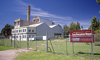
Yanco Powerhouse Museum is located at Binya Street in Yanco, New South Wales, Australia. Yanco Power Station was built in 1913 to supply power to the Murrumbidgee Irrigation Area, when power was required for general lightning and for the Leeton Butter Factory. The site on which it was constructed was chosen as it was close to the Yanco railway line for obtaining coal and close to a water source that would be used for condensing water using a secondhand 75 KW generator. 6.5 km (4.0 mi) of transmission lines were installed on flexible steel poles, the first of their kind in Australia. The station's construction is concrete. In 1937, the five story building was extended. It was decommissioned in 1957 when the Snowy Mountains Scheme was completed and hydro-electric power was supplied to the region.
Hulterstad is a small coastal town on the southeastern part of the island of Öland, Sweden. Hulterstad is situated at the eastern fringe of the Stora Alvaret, a limestone pavement habitat which hosts a diversity of rare plants and has been designated a World Heritage Site by UNESCO. Hulterstad is the municipal government center for this district and central records for centuries were kept at the Hulterstad Church. Significant gravefields and a Viking stone burial ship structure are located immediately south of Hulterstad. To the north is located the village of Alby, where a mesolithic village of early human settlement has been found, and to the south is the Ottenby Nature Reserve. Across the alvar to the west is the village of Gettlinge.

Chutkowice is a village in the administrative district of Gmina Drohiczyn, within Siemiatycze County, Podlaskie Voivodeship, in north-eastern Poland. It lies approximately 8 kilometres (5 mi) north-west of Drohiczyn, 21 km (13 mi) west of Siemiatycze, and 85 km (53 mi) south-west of the regional capital Białystok.
Wola Baranowska is a village in the administrative district of Gmina Baranów Sandomierski, within Tarnobrzeg County, Subcarpathian Voivodeship, in south-eastern Poland. It lies approximately 7 kilometres (4 mi) south-east of Baranów Sandomierski, 17 km (11 mi) south-west of Tarnobrzeg, and 56 km (35 mi) north-west of the regional capital Rzeszów.
Valente is a municipality in the state of Bahia in the North-East region of Brazil.

Milina is a village in the municipality of Loznica, Serbia. According to the 2002 census, the village has a population of 228 people.
Plane Table is a distinctive ice free mesa in the north part of the Asgard Range, Victoria Land. This flattish feature surmounts the area between Nibelungen Valley and the Sykes Glacier and commands an extensive view of Wright Valley. A descriptive name given by New Zealand Antarctic Place-Names Committee (NZ-APC).
Te Puna Roimata Peak is a peak located 1.5 nautical miles (2.8 km) west of Terra Nova Glacier and 2 nautical miles (3.7 km) south of Lewis Bay on the lower northeast slope of Mount Erebus, Ross Island. On November 28, 1979, a New Zealand DC10 aircraft on a scenic flight from Auckland crashed near this peak claiming the lives of 237 passengers from eight countries and a crew of 20. In 1987, a stainless steel memorial cross was erected west of the peak. Te Puna Roimata Peak was named by the New Zealand Geographic Board (NZGB) in 2000.
Fivebough and Tuckerbil Wetlands are two wetland sites within the Riverina and Murrumbidgee Irrigation Area (MIA), near Leeton in New South Wales, Australia. Both Fivebough and Tuckerbil sites form Crown reserve number 1030008 managed by NSW Department of Industry, for ecological conservation and public recreation. The reserve was recognised as being a Wetland of International Importance through designation under the Ramsar Convention on 21 October 2002 as Ramsar Site 1224