
The Cornucopia Jailhouse is a former jailhouse located on Second Street in the ghost town of Cornucopia, Oregon. The building was added to the National Register of Historic Places on November 24, 2014. [1]
The Cornucopia Jailhouse is a former jailhouse located on Second Street in the ghost town of Cornucopia, Oregon. The building was added to the National Register of Historic Places on November 24, 2014. [1]
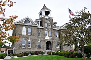
Wallowa County is the northeastern most county in the U.S. state of Oregon. As of the 2020 census, the population was 7,391, making it Oregon's fifth-least populous county. Its county seat is Enterprise. According to Oregon Geographic Names, the origins of the county's name are uncertain, with the most likely explanation being it is derived from the Nez Perce term for a structure of stakes used in fishing. An alternative explanation is that Wallowa is derived from a Nez Perce word for "winding water". The journals of Lewis and Clark Expedition record the name of the Wallowa River as Wil-le-wah.

Baker County is one of the 36 counties in the U.S. state of Oregon. As of the 2020 census, the population was 16,668. The county seat and largest city is Baker City. The county was organized on September 22, 1862, when a portion of Wasco County was partitioned off. The new county's area was reduced in 1864 when Union County was partitioned off, and again in 1887 when Malheur County was partitioned off. The county's lines were last adjusted in 1901 when a parcel was added to the county.
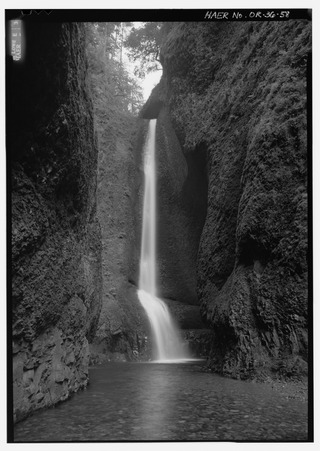
Oneonta Gorge is a scenic gorge located in the Columbia River Gorge area of the American state of Oregon. The U.S. Forest Service has designated it as a botanical area because of the unique aquatic and woodland plants that grow there. Exposed walls of 25-million-year-old basalt are home to a wide variety of ferns, mosses, hepatics, and lichens, many of which grow only in the Columbia River Gorge. Oneonta Gorge with its 50 species of wildflowers, flowering shrubs and trees has been described as "one of the true dramatic chasms in the state." The Oneonta Gorge Creek Bridge is listed on the National Register of Historic Places.

Frederic Joseph DeLongchamps was an American architect. He was one of Nevada's most prolific architects, yet is notable for entering the architectural profession with no extensive formal training. He has also been known as Frederick J. DeLongchamps, and was described by the latter name in an extensive review of the historic importance of his works which led to many of them being listed on the U.S. National Register of Historic Places in the 1980s.

Shepperd's Dell is a small canyon in the Columbia River Gorge in Oregon, located at 45.54833°N 122.195°W which is less than one-third mile southeast of Rooster Rock State Park. The Shepperd's Dell Bridge is listed on the National Register of Historic Places.
A cornucopia is a horn or horn-shaped basket and symbol of abundance. It may also refer to:
The AN/FPS-35 frequency diversity radar was a long range search radar used in the early 1960s. It was one of the largest air defense radars ever produced, with its antenna and supporting structure mounted on one of the largest rolling-element bearings in the world. In accordance with the Joint Electronics Type Designation System, the radar's designation represents the 35th design of an Army-Navy fixed radar(pulsed) electronic device for searching.

Cornucopia is a ghost town built during the gold mining boom of the 1880s in Eastern Oregon, United States. The town was officially platted in 1886 and was a mining town with various levels of success until it was abandoned in 1942. It is now primarily a tourist attraction as a ghost town. It is located east of Baker City high in the mountains of Pine Valley almost due north of Halfway, Oregon, on Oregon Route 86.
St. Elizabeth Health Services is a private Roman Catholic hospital in Baker City, Oregon, United States. It opened August 24, 1897 as St. Elizabeth Hospital. In 1912, a 115-bed facility was constructed at 2365 4th Street. The hospital moved to its current location on Pocahontas Road in April 1969.

The Portland and Southwestern Railroad Tunnel, also known as the Nehalem Divide Railroad Tunnel, is an abandoned railroad tunnel near Scappoose, Oregon, United States, that is listed on the National Register of Historic Places. The tunnel was driven by the Portland and Southwestern Railroad, whose chief business was logging. Unusually for a logging railroad, the Portland and Southwestern built tunnels. In order to reach the far side of the Nehalem divide in the Northern Oregon Coast Range, the railroad undertook a 1,712-foot (522 m) tunnel. Some work was started in 1910, but most work began in 1918 and was completed in 1919. Since the tunnel was not through solid rock, the tunnel was lined with timber. The tunnel was used until 1945, when it was replaced by a truck road over the divide.

The Theodore B. Wilcox Country Estate, located in Portland, Oregon, is listed on the National Register of Historic Places.

The Fred Harlow House, located in Troutdale, Oregon, is listed on the National Register of Historic Places. The building sits within the 1.4-acre (0.57 ha) Harlow House Park.

The James D. Robb House, located in Forest Grove, Oregon, is a house listed on the National Register of Historic Places.

The Thomas Michos House, located in Portland, Oregon, is a house listed on the National Register of Historic Places. The house is believed to be designed by Roscoe Hemenway, a well-known and prolific architect in Portland, Oregon. His name is listed as the heading in a 1975 Oregonian ad regarding this home. The landscape architect is believed to be Adolph Meyer of Alpine Gardens who designed the extensive gardens and stonework with ponds. He was Swiss-trained.

The Roe–Parker House is a historic house in Hood River, Oregon, United States.
Caples is an unincorporated community in Cowlitz County, Washington. The Caples community is located 2.5 miles (4.0 km) west of Woodland along Caples Road, on the east shore of Columbia River and across the river from Columbia City, Oregon. The Caples community is part of the Woodland School District, a K-12 school district of about 2,200 students.
The Dayton Opera House was an historic opera house located at 318 Ferry Street in Dayton, Oregon, United States. It was added to the National Register of Historic Places on March 16, 1987. It was destroyed by a fire on December 9, 1993., and was subsequently delisted on July 21, 1998.

The Lincoln Park Historic District in Pomona, California is a 45-block, 230-acre residential neighborhood. The district consists of 821 structures—primarily single family homes built between the 1890s through the 1940s—featuring a wide variety of architectural styles from late Victorian and National Folk homes, Craftsman and Craftsman-influenced homes, as well as late 19th and 20th Century Revival architectural styles including Colonial, Mission/Spanish, Tudor and Classical Revival.
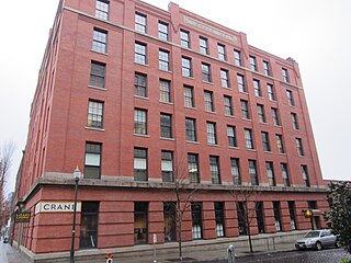
The Crane Building is an historic building in Portland, Oregon. Completed in 1909, the structure is part of the Portland Thirteenth Avenue Historic District, which is listed on the National Register of Historic Places.
45°00′25″N117°11′48″W / 45.0070°N 117.1968°W
| | This Oregon-related article is a stub. You can help Wikipedia by expanding it. |