Lehigh County is a county in the Commonwealth of Pennsylvania. As of the 2020 census, the county's population was 374,557. Its county seat is Allentown, the state's third-largest city after Philadelphia and Pittsburgh.

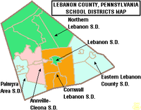
LebanonCounty is a county in the Commonwealth of Pennsylvania. As of the 2020 census, the population was 143,257. Its county seat is the city of Lebanon.

Lockport is a city in Will County, Illinois, United States, located 30 miles southwest of Chicago. Per the 2020 census, the population was 26,094. The city was incorporated in 1853. It is situated along the Illinois and Michigan (I&M) Canal, and was the headquarters of the canal when the canal was operating. A section of the canal runs through Lockport, including the remains of the canal's Lock No. 1 from which the town received its name. The canal right-of-way is now the Illinois and Michigan National Heritage Corridor.

Dormont is a borough in Allegheny County, Pennsylvania, United States. The population was 8,244 at the 2020 census. It is a residential suburb of the Pittsburgh metropolitan area. Loosely translated, Dormont means "Mountain of Gold" in French.

Mt. Lebanon is a township with home rule status in Allegheny County, Pennsylvania, United States. The population was 34,075 at the 2020 census. It is a suburb of Pittsburgh. Established in 1912 as Mount Lebanon, the township was a farming community. With the arrival of the first streetcar lines and the development of the first real estate subdivision, both in 1901, it became a streetcar suburb, offering residents the ability to commute to Downtown Pittsburgh. Furthermore, the opening of the Liberty Tunnel in 1924 allowed easy automobile access to Pittsburgh. In 1975, the renamed Mt. Lebanon adopted one of the first home rule charters in Pennsylvania.

Uwchlan Township is a township in Chester County, Pennsylvania, United States. The population was 19,161 at the 2020 census.
West Bradford Township is a township that is located in Chester County, Pennsylvania, United States. The population was 12,376 at the time of the 2010 census.

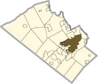
Lebanon is a city in and the county seat of Lebanon County, Pennsylvania, United States. The population was 26,814 at the 2020 census.

Palmyra is a borough in Lebanon County, Pennsylvania, United States. It is part of the Lebanon, Pennsylvania Metropolitan Statistical Area. The population was 7,807 at the 2020 census.

Emmaus is a borough in Lehigh County, Pennsylvania. As of the 2020 U.S. census, it had a population of 11,652. Emmaus is located in the Lehigh Valley, the third-largest metropolitan area in Pennsylvania and 68th-largest metropolitan area in the nation.

Lower Macungie Township is a township in Lehigh County, Pennsylvania. The township's population was 31,964 as of the 2020 census, making it the second-largest population center in Lehigh County after Allentown and the third-largest population center in the Lehigh Valley metropolitan area after Allentown and Bethlehem.

South Whitehall Township is a township in Lehigh County, Pennsylvania. The township's population was 19,180 at the 2010 census. It is a suburb of Allentown and is part of the Lehigh Valley, which had a population of 861,899 and was the 68th-most populous metropolitan area in the U.S. as of the 2020 census.
Orefield is a small unincorporated community in Lehigh County, Pennsylvania. The community is split between North Whitehall and South Whitehall townships. Orefield is part of the Lehigh Valley, which has a population of 861,899 and is the 68th-most populous metropolitan area in the U.S. as of the 2020 census.

This is a list of properties and districts listed on the National Register of Historic Places in Pennsylvania. As of 2015, there are over 3,000 listed sites in Pennsylvania. All 67 counties in Pennsylvania have listings on the National Register.
Cedar Crest Boulevard, colloquially known as Cedar Crest and The Boulevard, is a major north-south highway in Lehigh County, Pennsylvania in the Lehigh Valley region of eastern Pennsylvania. South of Interstate 78 (I-78), the road is part of Pennsylvania Route 29. North of it, the road becomes State Route 1019.
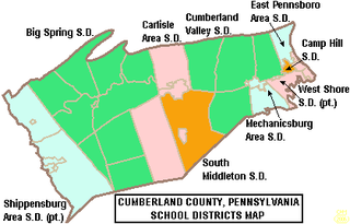
West Shore School District, is a large, suburban, public school district with its main office located in Lewisberry, Pennsylvania. This district serves students in eastern Cumberland County and northern York County. It serves the municipalities of Lemoyne, New Cumberland and Wormleysburg boroughs and Lower Allen Township in Cumberland County; Goldsboro and Lewisberry boroughs, Fairview Township and Newberry Township in York County. West Shore School District encompasses approximately 78 square miles (200 km2). According to 2000 federal census data, the district served a resident population of 57,960 people. By 2010, the district's population increased to 62,514 people.
The Allentown School District is a large, urban public school district located in Allentown, Pennsylvania in the Lehigh Valley region of eastern Pennsylvania. The district is the fourth-largest school district in Pennsylvania as of the 2016-17 academic year.
The Owen J. Roberts School District is a school district located in northern Chester County, Pennsylvania. its headquarters are in South Coventry Township, with a Pottstown postal address.