Related Research Articles
Fort Edmonton was the name of a series of trading posts of the Hudson's Bay Company (HBC) from 1795 to 1914, all of which were located on the north banks of the North Saskatchewan River in what is now central Alberta, Canada. It was one of the last points on the Carlton Trail, the main overland route for Metis freighters between the Red River Colony and the points west and was an important stop on the York Factory Express route between London, via Hudson Bay, and Fort Vancouver in the Columbia District. It also was a connection to the Great Northland, as it was situated relatively close to the Athabasca River whose waters flow into the Mackenzie River and the Arctic Ocean. Located on the farthest north of the major rivers flowing to the Hudson Bay and the HBC's shipping posts there, Edmonton was for a time the southernmost of the HBC's forts.
Bon Accord is a town in central Alberta, Canada. It is located 40 km (25 mi) north of downtown Edmonton on Highway 28. The name is derived from the French phrase "Bon Accord", the ancient motto of Aberdeen, Scotland, the ancestral home of a first settler.
Spruce Grove-Sturgeon-St. Albert was a provincial electoral district in Alberta, Canada mandated to return a single member to the Legislative Assembly of Alberta using the first-past-the-post method of voting from 1993 to 2012.
Clare Drake Arena is a 3,009-seat multi-purpose arena in Edmonton, Alberta, Canada. It is home to the University of Alberta Golden Bears and Pandas ice hockey teams and was named after former University of Alberta Golden Bears hockey coach, Clare Drake, who led the Golden Bears to 697 career wins.

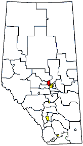
Division No. 11 is a census division in Alberta, Canada. Surrounding the City of Edmonton, the majority of the division comprises Alberta's Capital Region, while the western and southern portions of the division are located within central Alberta. The division also forms the northern segment of the Calgary–Edmonton Corridor.

Aldersyde is a hamlet in Alberta, Canada within the Foothills County. Located between Highway 2 and Highway 2A south of Highway 7, the hamlet is approximately 8 kilometres (5.0 mi) southeast of Okotoks, 10 kilometres (6.2 mi) north of High River and 25 kilometres (16 mi) south of Calgary. The Canadian Pacific Railway Aldersyde subdivision runs through the hamlet.
The Enoch Cree Nation #440 is a First Nations band government in Alberta, Canada. Members of the Nation are of Cree ancestry and speak the Plains Cree dialect of the Cree language group. The band is a signatory of Treaty 6 and is a member of the Confederacy of Treaty Six First Nations. The chief of the Enoch Cree Nation is Cody Thomas.

South Cooking Lake is a hamlet in Alberta, Canada within Strathcona County. It is located on Highway 14, approximately 19 km (12 mi) southeast of Sherwood Park.
Glenwood is a village in southern Alberta, Canada. It is located north of the Town of Cardston, in Cardston County. The village was named for a man named Edward Glen Wood. The founder of the village was Edward J. Wood, successor to Latter Day Saint leader Charles Ora Card, the founder of Cardston. Both Glen and Edward Wood were from Salt Lake City, Utah, and are buried in Cardston. The old name for the village was Glenwoodville until 1979.
There are several lakes named Mud Lake within the Canadian province of Alberta.

The Universiade Pavilion, better known as the Butterdome, is a 5,500-seat multi-purpose arena in Edmonton, Alberta, Canada, on the campus of the University of Alberta. It was built for the 1983 Summer Universiade.

Foote Field is a multi-purpose sports facility on the University of Alberta campus in Edmonton, Alberta, Canada, built as a legacy facility for the 2001 World Championships in Athletics. It was named for University of Alberta alumnus, former varsity track athlete, and philanthropist Eldon Foote, who donated $2 million toward the construction costs.
Blackmud Creek is a creek in Edmonton that flows into Whitemud Creek. The creek starts at Saunders Lake East of Nisku and runs northwest into the City, joining Whitemud Creek in the neighbourhood of Twin Brooks.
The Saville Community Sports Centre is a sports facility run by the University of Alberta's Faculty of Physical Education and Recreation, where it is located in Edmonton, Alberta. It features a curling rink, tennis courts and a gymnasium.
Bartstow is a locality in Alberta, Canada.
Cannell is an industrial area within the Mistatim Industrial neighbourhood in Edmonton, Alberta, Canada. Cannell was formerly an unincorporated area in Parkland County, until the 1982 Edmonton general annexation.
Conjuring Creek is a stream in Alberta, Canada, and is a minor tributary of the North Saskatchewan River. It originates at Wizard Lake and drains into the North Saskatchewan River. It runs from south to north passing through the town of Calmar.
Coutts River is a stream in Alberta, Canada.
Edmonton-Highlands-Beverly was a provincial electoral district in Alberta, Canada, mandated to return a single member to the Legislative Assembly of Alberta using the first past the post method of voting from 1993 to 1997.
Edmonton-Glengarry was a provincial electoral district in Alberta, Canada, mandated to return a single member to the Legislative Assembly of Alberta using the first past the post method of voting from 1979 to 2004.
References
- ↑ "Coronado". Geographical Names Data Base . Natural Resources Canada.
- ↑ Place-names of Alberta. Ottawa: Geographic Board of Canada. 1928. p. 38.
53°53′00″N113°18′07″W / 53.88345°N 113.30201°W
| | This Edmonton Metropolitan Region location article is a stub. You can help Wikipedia by expanding it. |