
The Arctic Archipelago, also known as the Canadian Arctic Archipelago, is an archipelago lying to the north of the Canadian continental mainland, excluding Greenland and Iceland.

The Banda Sea is one of four seas that surround the Maluku Islands of Indonesia, connected to the Pacific Ocean, but surrounded by hundreds of islands, including Timor, as well as the Halmahera and Ceram Seas. It is about 1000 km (600 mi) east to west, and about 500 km (300 mi) north to south.

Booth Island is a Y-shaped island, 5 nautical miles long and rising to 980 metres (3,220 ft) in the northeast part of the Wilhelm Archipelago, Antarctica.
The Scaife Mountains is a group of mountains rising west of Prehn Peninsula and between the Ketchum Glacier and Ueda Glacier, at the base of the Antarctic Peninsula.

James Ross Island is a large island off the southeast side and near the northeastern extremity of the Antarctic Peninsula, from which it is separated by Prince Gustav Channel. Rising to 1,630 metres (5,350 ft), it is irregularly shaped and extends 40 nautical miles in a north–south direction.

The Prince Charles Mountains are a major group of mountains in Mac. Robertson Land in Antarctica, including the Athos Range, the Porthos Range, and the Aramis Range. The highest peak is Mount Menzies, with a height of 3,228 m (10,591 ft). Other prominent peaks are Mount Izabelle and Mount Stinear. These mountains, together with other scattered peaks, form an arc about 420 km (260 mi) long, extending from the vicinity of Mount Starlight in the north to Goodspeed Nunataks in the south.
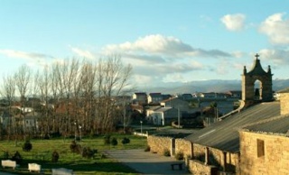
Peque is a village and municipality in the province of Zamora, part of the autonomous community of Castile and León, Spain. It has a population of approximately 124 inhabitants as of the 2023 Continuous Register.

The South Mainland of the Shetland Islands is the southern peninsula of Mainland island. It lies south of Hellister. The greater southern part of the peninsula belongs to the civil parish of Dunrossness. The rest belongs to the parishes of Lerwick and Tingwall. St Ninian's Isle is a tidal island off its west coast.
Keilhau Glacier is a glacier 5 nautical miles (9 km) long flowing west from Kohl Plateau and then southwest to Jossac Bight, on the south coast of South Georgia. It was mapped by Olaf Holtedahl during his visit to South Georgia in 1927–28, and named by him for Baltazar M. Keilhau, a Norwegian geologist and professor of mineralogy at the University of Christiania.
The Mariner Glacier is a major glacier over 60 nautical miles long, descending southeast from the plateau of Victoria Land, Antarctica, between Mountaineer Range and Malta Plateau, and terminating at Lady Newnes Bay, Ross Sea, where it forms the floating Mariner Glacier Tongue.

Ulu Peninsula is that portion of James Ross Island northwest of the narrow neck of land between Rohss Bay and Croft Bay, extending from Cape Obelisk to Cape Lachman, in Antarctica.

Flandres Bay is a large bay lying between Cape Renard and Cape Willems, along the west coast of Graham Land, Antarctica.

Lawrie Glacier is a glacier flowing between Mount Genecand and Mezzo Buttress, and entering the head of Barilari Bay between Cherkovna Point and Prestoy Point on the west coast of Graham Land, Antarctica. It was charted by the British Graham Land Expedition under Rymill, 1934–37, and was named by the UK Antarctic Place-Names Committee in 1959 for Robert Lawrie, an English alpine and polar equipment specialist.
Olímpio Noronha is a municipality in the state of Minas Gerais in the Southeast region of Brazil.

Heikinlaakso (Finnish), Henriksdal (Swedish) is a northeastern neighborhood of Helsinki, Finland.
Canyon Glacier is a narrow glacier, 35 nautical miles long, flowing to the Ross Ice Shelf. It drains the northwest slopes of Mount Wexler and moves northward between steep canyon walls of the Separation Range and Hughes Range to join the ice shelf immediately west of Giovinco Ice Piedmont. The glacier was observed from nearby Mount Patrick by the New Zealand Alpine Club Antarctic Expedition (1959–60) who gave the descriptive name.
Weir Glacier is a glacier 8 nautical miles (15 km) long, flowing north into the south part of Barilari Bay between Prestoy Point and Byaga Point, on the west coast of Graham Land. First sighted and roughly charted in 1909 by the French Antarctic Expedition under Charcot. It was surveyed in 1935-36 by the British Graham Land Expedition (BGLE) under Rymill and later named for William D. Weir, 1st Viscount Weir of Eastwood, and his son, the Hon. James K. Weir, who contributed toward the cost of the BGLE, 1934–37.

Hoek Glacier is a glacier flowing into Dimitrov Cove northeast of Veshka Point on the northwest coast of Velingrad Peninsula on Graham Coast in Graham Land, Antarctica, southward of the Llanquihue Islands. It was charted by the British Graham Land Expedition under John Rymill, 1934–37, and was named by the UK Antarctic Place-Names Committee in 1959 for Henry W. Hoek (1878–1951), a pioneer Swiss ski-mountaineer and author of one of the earliest skiing manuals.
Sjögren Glacier is a glacier 15 nautical miles long in the south part of Trinity Peninsula, Antarctica. It flows southeast from Detroit Plateau to the south side of Mount Wild, where it enters Prince Gustav Channel.