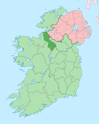
County Leitrim is a county in Ireland. It is in the province of Connacht and is part of the Northern and Western Region. It is named after the village of Leitrim. Leitrim County Council is the local authority for the county, which had a population of 35,087 according to the 2022 census.

Manorhamilton is the second-largest town in County Leitrim, Ireland. It is located on the N16 26 kilometres (16 mi) from Sligo and 41 kilometres (25 mi) from Enniskillen.

Ballysadare, locally also Ballisodare, is a town in County Sligo, Ireland. It is about 7 kilometres south of Sligo town. The town developed on an important crossing of the Owenmore River.

Dromahair is a village in County Leitrim in the northern part of Connacht, the western province in Ireland. Dromahair is 10 km (6 mi) from Manorhamilton and 17 km (10 mi) from Sligo town.
Kinlough is a large village in north County Leitrim. It lies between the Dartry Mountains and the Atlantic Ocean, and between the River Duff and the River Drowes, at the head of Lough Melvin. It borders counties Donegal and Fermanagh and is near Yeats Country. It lies 2.5 miles from Bundoran, County Donegal, and across Lough Melvin from Garrison, County Fermanagh.

Tullaghan is the most northerly village in County Leitrim. Lying at the northern end of Glenade, Tullaghan is in the parish of Kinlough and Glenade and is part of the Manorhamilton electoral area.

Blacklion is a border village in west County Cavan, Ireland. It is situated on the N16 national primary road, just across the border from the County Fermanagh village of Belcoo.

The Black Pig's Dyke or Worm's Ditch is a series of discontinuous linear earthworks in southwest Ulster and northeast Connacht, Ireland. Remnants can be found in north County Leitrim, north County Longford, County Cavan, County Monaghan and County Fermanagh. Sometimes, the Dorsey enclosure in County Armagh and the Dane's Cast in County Down are considered to be part of the dyke.
Dunmakeever is a townland in the Civil Parish of Kinawley, Roman Catholic Parish of Glangevlin, Barony of Tullyhaw, County Cavan, Ireland.

The R282 road is a regional road in County Leitrim, Ireland connecting the N16 in Manorhamilton with Rossinver and across the border around Lough Melvin becoming the B53 to Garrison, County Fermanagh.

Glenade Lough, locally known as Glenade Lake, is a freshwater lake in the northwest of Ireland. It is located in north County Leitrim in the Glenade Valley.
Killyran is a townland in the civil parish of Templeport, County Cavan, Ireland. It lies in the Roman Catholic parish of Templeport and barony of Tullyhaw.
Lough Conway is a very small freshwater lake in northwest Ireland.
Corracleigh, an Anglicisation of the Gaelic, ‘Corr na Cloiche’ meaning The Round Hill of the Stone, is a townland in the civil parish of Templeport, County Cavan, Ireland. It lies in the Roman Catholic parish of Glangevlin and barony of Tullyhaw. The local pronunciation is Curracliff.

Derrynananta Lower, an Anglicisation of the Gaelic, ‘Doire na Neannta Íochtar’, meaning The Lower Oak-wood of the Nettles, is a townland in the civil parish of Templeport, County Cavan, Ireland. It lies in the Roman Catholic parish of Glangevlin and barony of Tullyhaw.

Drumhurrin, an Anglicisation of the Gaelic ‘Droim Shoirn’, meaning The Hill-Ridge of the Lime-Kiln or Furnace, is a townland in the civil parish of Templeport, County Cavan, Ireland. It lies in the Roman Catholic parish of Glangevlin and barony of Tullyhaw.
Mully Upper, an Anglicisation of the Gaelic, ‘Mullach Uachtar’ meaning The Upper Summit of the Hill, is a townland in the civil parish of Templeport, County Cavan, Ireland. It lies in the Roman Catholic parish of Glangevlin and barony of Tullyhaw.

The Yellow River is a watercourse wholly in County Leitrim, Ireland. It is one of two rivers of this name in the county, the other originating at Doon, County Cavan.

The Finn River, also known as the River Finn, is a small river that flows through parts of County Fermanagh and parts of County Monaghan in the south of Ulster, the northern province in Ireland. In certain places, the river forms part of the boundary between County Fermanagh, which is part of Northern Ireland, and County Monaghan, which is part of the Republic of Ireland. Two very short stretches of the river, just north of Redhills and at Castle Saunderson, near Belturbet, also form part of the boundary between County Fermanagh and County Cavan. This means that some stretches of the river form part of the border between Northern Ireland and the Republic of Ireland, these short stretches also forming part of the external border of the European Union.
Rockfield Lake, also known as Rockfield Lough, is a lake or lough situated between Carrigallen and Killeshandra, two small towns on the northern edge of the Midlands in Ireland. Part of the lake is in County Leitrim, which is part of the Province of Connacht, while most of the lake is in County Cavan, which is part of the Province of Ulster. This means that the provincial boundary between Connacht and Ulster runs through the lough. The Cullies River flows through Rockfield Lake, entering the lake at its southern end and flowing out of the lake at its north-western end. This small river flows from nearby Cullies Lake, and flows on, via Drumhart Lake, through Rockfield Lake to Glasshouse Lake.


