
Dorset is a ceremonial county in South West England. It is bordered by Somerset to the north-west, Wiltshire to the north-east, Hampshire to the east, the English Channel to the south, and Devon to the west. The largest settlement is Bournemouth, and the county town is Dorchester.

Sherborne is a market town and civil parish in north west Dorset, in South West England. It is sited on the River Yeo, on the edge of the Blackmore Vale, 6 miles east of Yeovil. The parish includes the hamlets of Nether Coombe and Lower Clatcombe. The A30 road, which connects London to Penzance, runs through the town. In the 2011 census the population of Sherborne parish and the two electoral wards was 9,523. 28.7% of the population is aged 65 or older.

West Dorset was a local government district in Dorset, England. The district was formed on 1 April 1974 under the Local Government Act 1972, and was a merger of the boroughs of Bridport, Dorchester and Lyme Regis, along with Sherborne urban district and the rural districts of Beaminster, Bridport, Dorchester and Sherborne. Its council was based in Dorchester.

The A35 is a major road in southern England, connecting Honiton in Devon and Southampton in Hampshire. It is a trunk road for some of its length. Most of its route passes through Dorset and the New Forest. It originally connected Exeter and Southampton, the original A35 ran along what is now the A3052 joining the present road at Charmouth.

Bradford Peverell is a village and civil parish in the English county of Dorset, 2 miles (3.2 km) north-west of the county town Dorchester. It is sited by the south bank of the River Frome, among low chalk hills on the dip slope of the Dorset Downs. The A37 road between Dorchester and Yeovil passes to the north of the village on the other side of the river's water meadows. In the 2011 census the population of the parish was 370.

Chetnole is a village and civil parish in the county of Dorset in southern England. It lies approximately 6 miles (9.7 km) south-southwest of Sherborne and 5.5 miles (8.9 km) southeast of Yeovil in Somerset. It is sited on Oxford clay by the small Wriggle River at the western end of the Blackmore Vale. There are around 128 houses in the village. It has a railway station on the Heart of Wessex Line that is served by Great Western Railway services. Dorset County Council estimate that in 2013 the population of the parish was 330. In the 2011 census the population of Chetnole parish combined with the small parish of Stockwood to the west was 344.

Leigh is a village and civil parish in the county of Dorset in southern England, situated approximately 5 miles (8.0 km) south-southwest of Sherborne. It is known as the site of a former Miz Maze. In the 2011 census the parish had a population of 480.

Dorset is a rural county in south west England. Its archaeology documents much of the history of southern England.
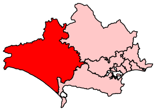
West Dorset is a constituency represented in the House of Commons of the UK Parliament since 2019 by Chris Loder, a Conservative.

Upwey is a suburb of Weymouth in south Dorset, England. The suburb is situated on the B3159 road in the Wey valley. The area was formerly a village until it was absorbed into the Weymouth built-up area. It is located four miles north of the town centre in the outer suburbs. During the Census 2001 the combined population of Upwey and neighbouring Broadwey was 4,349.

Cruxton is a hamlet in the English county of Dorset. It lies eight miles north-west of the county town of Dorchester, and one mile south-east of the village of Maiden Newton. It is sited on the west bank of the River Frome, amongst the chalk hills of the Dorset Downs.

Poundbury Hill is the site of a scheduled Prehistoric and Roman archaeological remains and includes evidence of a Neolithic settlement, a substantial Bronze Age occupation site and an Iron Age hillfort. There are also late Iron Age burials and a section of Roman aqueduct. On the eastern side is an earlier Romano-British farmstead; and an extensive later cemetery, belonging to the Roman town Durnovaria.

Sherborne Town Football Club are a football club based in the town of Sherborne, Dorset, England. They are currently members of the Wessex League Premier Division and play at Raleigh Grove. The club is affiliated to the Dorset County Football Association and is a FA chartered Standard club.

Fordington is a part of the town of Dorchester, Dorset; originally a separate village, it has now become a suburb. Taking its name from a ford across the River Frome, it grew up around the church of St. George, though the parish was much larger and surrounded Dorchester on three sides. It was part of the liberty of Fordington.

Stockwood is a village in west Dorset, England, around eight miles south-west of Sherborne and less than a mile away from Chetnole railway station on the Heart of Wessex Line. There are a few houses on the road leading to the A37 between Yeovil and Dorchester.
Horton Priory was a priory at Horton in Dorset, England.

Dorset is a county located in the middle of the south coast of England. It lies between the latitudes 50.512°N and 51.081°N and the longitudes 1.682°W and 2.958°W, and occupies an area of 2,653 km2. It spans 90 kilometres (56 mi) from east to west and 63 kilometres (39 mi) from north to south.

Nether Cerne is a hamlet and civil parish in the English county of Dorset. It lies within the Dorset unitary authority administrative area, about 5 miles (8.0 km) north of the county town Dorchester and 12 miles (19 km) south of Sherborne. The A352 road which connects those towns lies about 250 metres (270 yd) to the west. Dorset County Council's latest (2013) estimate of the parish population is 20.

Winterborne Herringston, also Winterbourne Herringston, is a small civil parish and hamlet containing about 600 acres in Dorset, England, 1.4 miles south of Dorchester. The only significant structure is Herringston House, a Grade II* listed 14th-century manor house which has been the home of the Williams family since 1513.
