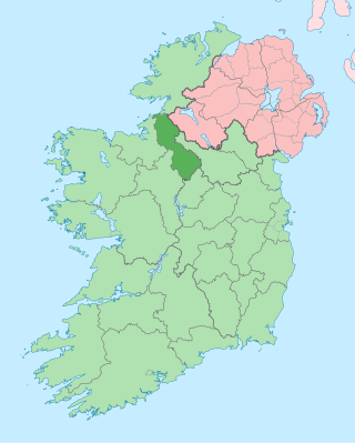
County Leitrim is a county in Ireland. It is in the province of Connacht and is part of the Northern and Western Region. It is named after the village of Leitrim. Leitrim County Council is the local authority for the county, which had a population of 35,199 according to the 2022 census.

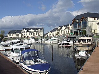
Carrick-on-Shannon is the county town of County Leitrim in Ireland. It is the largest town in the county. A smaller part of the town located on the west bank of the River Shannon lies in County Roscommon and is home to the town's main train station. As of the 2022 census, the population of the town was 4,743. It is situated on a strategic crossing point of the River Shannon. The main part of the town, the County Leitrim part, is in the civil parish of Kiltoghert, which is in the barony of Leitrim, while Cortober, which is the County Roscommon side of the town, is in the civil parish of Killukin, in the barony of Boyle.
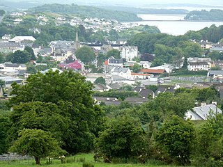
Donegal is a town in County Donegal in Ulster, the northern province in Ireland. Although Donegal gave its name to the county, now Lifford is the county town. From the 15th until the early 17th century, Donegal was the "capital" of Tyrconnell, a Gaelic kingdom controlled by the O'Donnell dynasty of the Northern Uí Néill. The town is in a civil parish of the same name.

Drumshanbo is a small town situated in the heart of County Leitrim, Ireland. Drumshanbo is surrounded by a scenic area of soft rolling hills, woodlands, lakes and the Sliabh an Iarainn and Arigna mountains. It is a well preserved town with traditional pubs, shops, and restaurants.
Leitrim is a village in County Leitrim, Ireland, on the River Shannon near the border with County Roscommon. It is at the junction of the R280 and R284 regional roads.
Fenagh is a village in the south-east of County Leitrim in Ireland. It is 4.8 kilometres south-west of Ballinamore and 12 kilometres (7 mi) north of Mohill, the village being on the R202 road. The village is in a civil parish of the same name. Fenagh is located in the eastern 'spur' of the Barony of Leitrim.
Leitrim County Council is the local authority of County Leitrim, Ireland. As a county council, it is governed by the Local Government Act 2001. The council is responsible for housing and community, roads and transportation, urban planning and development, amenity and culture, and environment. The council has 18 elected members. Elections are held every five years and are by single transferable vote. The head of the council has the title of Cathaoirleach (chairperson). The county administration is headed by a chief executive, Joseph Gilhooly. The county town is Carrick-on-Shannon.

The Leitrim Senior Hurling Club Championship is an annual hurling competition contested by top-tier Leitrim GAA clubs. The winners of the championship qualify to the Connacht Junior Club Hurling Championship.

The Diocese of Ardagh and Clonmacnoise is a Latin Church diocese of the Catholic Church in Ireland.

South London Crematorium and Streatham Park Cemetery is a cemetery and crematorium on Rowan Road in Streatham Vale. It has always been privately owned and managed and is now part of the Dignity plc group. The South London Crematorium is situated within the cemetery grounds and opened in 1936.
The Sheemore ambush was an ambush carried out by the Irish Republican Army (IRA) on 4 March 1921, during the Irish War of Independence. It took place at Sheemore near Carrick-on-Shannon, County Leitrim.

Drypool is an area within the city of Kingston upon Hull, in the ceremonial county of the East Riding of Yorkshire, England.

The Boyle River is a river in Ireland. Forming part of the Shannon River Basin, it flows from Lough Gara on the Sligo/Roscommon county border and thence through the town of Boyle to Lough Key. From there is continues eastwards through the village of Knockvicar to the River Shannon at Lough Drumharlow, near Carrick-on-Shannon. The length of the Boyle River is 64.4 km (40 mi). The area of its basin is 725 km2.
Cloonsheerevagh is a townland in Carrick-on-Shannon in County Leitrim, Ireland.
Killukin, sometimes known as Killucan, is a civil parish in the barony of Boyle, County Roscommon in Ireland. It is located on the road from Carrick-on-Shannon to Elphin containing part of the market and post town of Carrick. It is bounded on the north by the parish of Toomna, on the west by the parishes of Eastersnow and Ardcarne, on the south by the parish of Killummond, and on the east by the River Shannon.

St Mary's Kiltoghert, is a Gaelic Athletic Association club, it is based in the parish of Kiltoghert which is near Carrick-on-Shannon, County Leitrim, Ireland. In March 1944 the club was founded. They have won 6 Leitrim Senior Football Championships in 1958, 1995, 2003, 2007, 2013 and 2022. They have won 31 Leitrim Senior Hurling Championships including 12 in a row between 1999 and 2010.
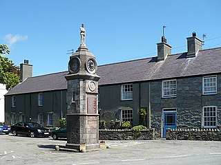
Llanfechell is a village in Anglesey, Wales. It is the largest of several small villages and dispersed settlements that make up Mechell Community Council area. It is 11 miles (18 km) east of Holyhead, and 5.6 miles (9 km) west of Amlwch, in the north of the island.

The Muintir Eolais of Conmaicne Réin were nobles of Gaelic Ireland. For seven hundred years from the 8th century, they lived in and ruled an area roughly conterminous with present-day south County Leitrim. Their territory comprised the lands named Maigh Nissi and Maigh Rein, today the baronies of Leitrim and Mohill respectively.

The barony of Leitrim is a barony in County Leitrim, Ireland.
Hull General Cemetery was established by a private company in 1847 on Spring Bank in the west of Kingston upon Hull, East Riding of Yorkshire, England. In 1862 the Hull Corporation established a cemetery adjacent, now known as Western Cemetery, and in c. 1890 expanded the cemetery west across Chanterlands Avenue onto an adjacent site.
