
Phinney Ridge is a neighborhood in north central Seattle, Washington, United States. It is named after the ridge which runs north and south, separating Ballard from Green Lake, from approximately N. 45th to N. 85th Street. The ridge, in turn, is named after Guy C. Phinney, lumber mill owner and real estate developer, whose estate was bought by the city and turned into Woodland Park in 1899. Phinney's estate had included a private menagerie, and the western half of the park became what is now the Woodland Park Zoo.

Green River College is a public college in Auburn, Washington. It has a student body of approximately 10,000. Although it began awarding Bachelor's degrees in 2014, it awards primarily Associate degrees.

Nairn Falls Provincial Park is a provincial park in British Columbia, Canada located on the Green River adjacent to British Columbia Highway 99 and the Canadian National Railway line just south of Pemberton and less than twenty minutes north of the resort town of Whistler. The 170 hectare park was established in 1966, shortly after the highway's opening, to protect and enhance visitor access to Nairn Falls, a double waterfall connected by a small canyon which throttles the flow of the Green River just before its accession to the lowlands of the Pemberton Valley and its confluence with the Lillooet River just above that river's estuary into Lillooet Lake.
Prophet River Wayside Provincial Park is a provincial park in British Columbia, Canada. It is located along Prophet River, by the Alaska Highway, between the localities of Trutch and Prophet River. Originally created as a Provincial Recreation Area in 1977 with an area of 707 acres (2.86 km2), it was designated a provincial park in 1999 with an area of 111 hectares.
The Foothills Trail is a mostly paved non-motorized rail-trail in east Pierce County, Washington, extending uninterrupted for 15 miles (24 km) from Puyallup, Washington to Orting, Washington to South Prairie, Washington. The trail is used by cyclists, walkers, joggers, inline skaters, and horse riders. Listed as Foothills Regional Trail, it was designated a National Recreation Trail in 2012.
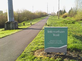
The Interurban Trail South is a rail trail in King and Pierce counties, Washington. The interurban trail North is a bicycle route running from Downtown Seattle through Shoreline and to the Snohomish County, Washington line.

Fort Dent is a historic fort and present-day park in Tukwila, Washington.
Pinehurst is a neighborhood in the Northgate area of Seattle, Washington, United States. It is bounded by NE 145th Street to the north, NE Northgate Way to the south, I-5 to the west, and Lake City Way to the east. These boundaries were determined by the Pinehurst Community Council. Pinehurst's northern boundary of NE 145th Street makes Pinehurst one of the northernmost neighborhoods in the city of Seattle.

The Mazowe River is a river in Zimbabwe and Mozambique.
Orillia, Washington was a former community, southwest of Renton in the Green River Valley of King County in the U.S. state of Washington. At one time, it had a schoolhouse. Today it lies on the border between the cities of Kent, Tukwila and Renton.
Riverton was a census-designated place (CDP) in King County, Washington, United States. The population was 6,407 at the 2010 census. Riverton was formerly part of the Riverton-Boulevard Park CDP, which was split up for the 2010 census into Riverton and Boulevard Park. In April 2010 the community was annexed by the city of Burien and is no longer a CDP.

Foster, Washington was a former community in King County in the U.S. state of Washington. Today, after being annexed in 1989, Foster's former area is a part of the city of Tukwila.
O'Brien, Washington was a former community, north of Kent in the Green River Valley of King County in the U.S. state of Washington. It was just north of today's Green River Natural Resources Area, on the right bank of the river. At one time, it had a post office and a school.
Wedge Pass, also known as Billygoat Pass, 1430 m (4692 ft), is a mountain pass in the northern Garibaldi Ranges, the southwesternmost subdivisions of the Pacific Ranges of the Coast Mountains in British Columbia, Canada. Located immediately on the southern flank of Wedge Mountain and to the immediate north of the Spearhead Range, site of the Blackcomb half of the Whistler Blackcomb Ski Area, it connects the head of Wedge Creek (W), a tributary of the Green River with those of Billgoat Creek (E), a tributary of the Lillooet River. The pass is within Garibaldi Provincial Park and has no road access.

The Green River Trail is a 19.6-mile (31.5 km) pedestrian and bicycle trail in King County, Washington, USA. It runs along the banks of the Duwamish and Green Rivers, crossing the river several times on bridges. The trail goes through a variety of landscapes, ranging from industrial to rural.
Forterra, based in Seattle, Washington, US, is the state of Washington’s largest land conservation, stewardship and community building organization dedicated solely to the region. The Cascade Land Conservancy is a non-profit, 501(c)(3) organization governed by a Board of Directors.
The Kolinbiné River is a river in West Africa. It arises in southern Mauritania and flows south, forming part of the international boundary between Mauritania and Mali. In Mali, it joins the Sénégal River 5 km upstream from the town of Kayes.
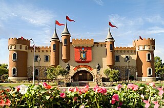
Golfland Entertainment Centers are a chain of family amusement centers, miniature golf courses, and water parks located in California and Arizona. The company was founded in 1953.
Point Robinson is the northern point on Maury Island, Washington, United States, near the town of Vashon on Vashon Island. It extends about 2,000 meters from Maury Island.


