
Cochise County is a county in the southeastern corner of the U.S. state of Arizona. It is named after the Native American chief Cochise.

St. David is a census-designated place (CDP) in Cochise County, Arizona, United States. The population was 1,699 at the 2010 census.
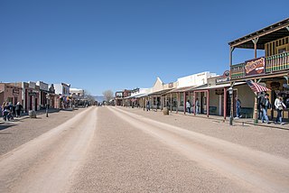
Tombstone is a historic city in Cochise County, Arizona, United States, founded in 1877 by prospector Ed Schieffelin in what was then Pima County, Arizona Territory. It became one of the last boomtowns in the American frontier. The town grew significantly into the mid-1880s as the local mines produced $40 to $85 million in silver bullion, the largest productive silver district in Arizona. Its population grew from 100 to around 14,000 in less than seven years. It is best known as the site of the Gunfight at the O.K. Corral and presently draws most of its revenue from tourism. It also houses the highest-rated brewery in the state of Arizona.

This is a list of properties and historic districts in Iowa that are listed on the National Register of Historic Places. There are listings in all of Iowa's 99 counties, adding up to over 2,300 total.

This is a directory of properties and districts listed on the National Register of Historic Places in Arizona. There are about fourteen hundred listed sites in the state, and each of its fifteen counties has at least ten listings on the National Register. Forty-seven of the state's sites are further designated as National Historic Landmarks.

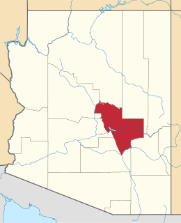
This is a list of the National Register of Historic Places listings in Maricopa County, Arizona, excluding those in Phoenix, for which see this separate list.

This is a list of the National Register of Historic Places listings in Lackawanna County, Pennsylvania.

This is a list of the National Register of Historic Places listings in Yuma County, Arizona. It is intended to be a complete list of the properties and districts on the National Register of Historic Places in Yuma County, Arizona, United States. The locations of National Register properties and districts for which the latitude and longitude coordinates are included below, may be seen in a map.
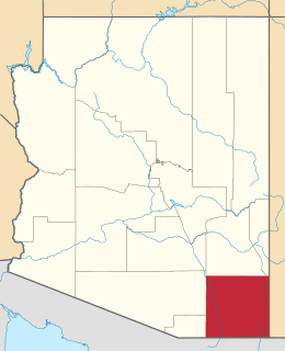
This is a list of the National Register of Historic Places listings in Cochise County, Arizona. It is intended to be a complete list of the properties and districts on the National Register of Historic Places in Cochise County, Arizona, United States. The locations of National Register properties and districts for which the latitude and longitude coordinates are included below, may be seen in a map.
This is a list of the National Register of Historic Places listings in Gila County, Arizona.

This is a list of the National Register of Historic Places listings in Phoenix, Arizona.

This is a list of the National Register of Historic Places listings in Linn County, Iowa.
This is a list of the National Register of Historic Places listings in Shelby County, Tennessee.
This is a list of the National Register of Historic Places listings in Williamson County, Tennessee.

Apache Nitrogen Products began in 1920 as an American manufacturer of nitroglycerin-based explosives (dynamite) for the mining industry and other regional users of dynamite. It occupies a historic location in Cochise County, Arizona, and is one of the county's largest employers. The company changed its name to Apache Nitrogen Products in 1990.

Charles M. Roberts was an American politician who served in the first Arizona State Senate.

Barfoot Lookout Complex is a forest lookout situated on Buena Vista Peak in the Douglas Ranger District in the Chiricahua Mountains in Cochise County, Arizona. It was built in 1935, perhaps by members of the Civilian Conservation Corps. The complex "represents one of the best examples of its type in the Southwestern Region", and consists of a 14 foot by 14 foot lookout house, shed, privy, concrete cistern, and a native stone retaining wall. When it was designated by the NHRP, none of the structures had any modifications since they had been built. The complex is approximately 80 feet by 80 feet, with the retaining wall along the west edge of the boundary.

The Douglas Residential Historic District is an area located in Douglas, Arizona, consisting of almost 500 buildings, of which 325 are contributing structures to the District. Architectural styles include Late 19th and 20th Century Revival; Bungalow, Craftsman, Victorian, and Queen Anne.
