Prairies are ecosystems considered part of the temperate grasslands, savannas, and shrublands biome by ecologists, based on similar temperate climates, moderate rainfall, and a composition of grasses, herbs, and shrubs, rather than trees, as the dominant vegetation type. Temperate grassland regions include the Pampas of Argentina, Brazil and Uruguay, and the steppe of Ukraine, Russia, and Kazakhstan. Lands typically referred to as "prairie" tend to be in North America. The term encompasses the lower and mid-latitude of the area referred to as the Interior Plains of Canada, the United States, and Mexico. It includes all of the Great Plains as well as the wetter, hillier land to the east. From west to east, generally the drier expanse of shortgrass prairie gives way to mixed grass prairie and ultimately the richer soils of the tallgrass prairie.

Goobang is a national park located in New South Wales, Australia, 296 kilometres (184 mi) northwest of Sydney. It protects the largest remnant forest and woodland in the central west region of the state, where interior and coastal New South Wales flora and fauna species overlap. Originally named Herveys Range by John Oxley in 1817, the area was reserved in 1897 as state forest because of its importance as a timber resource, and was designated a national park in 1995.

Grass Valley is a city in Nevada County, California, United States. As of the 2010 United States Census, its population was 12,860. Situated at roughly 2,500 feet (760 m) in elevation in the western foothills of the Sierra Nevada mountain range, this northern Gold Country city is 57 miles (92 km) by car from Sacramento and 88 miles (142 km) west of Reno.

A grassland is an area where the vegetation is dominated by grasses (Poaceae). However, sedge (Cyperaceae) and rush (Juncaceae) can also be found along with variable proportions of legumes, like clover, and other herbs. Grasslands occur naturally on all continents except Antarctica and are found in most ecoregions of the Earth. Furthermore, grasslands are one of the largest biomes on Earth and dominate the landscape worldwide. There are different types of grasslands: natural grasslands, semi-natural grasslands, and agricultural grasslands. They cover 31–69% of the Earth's land area.

The Piedmont is a plateau region located in the Eastern United States. It is situated between the Atlantic Plain and the Blue Ridge Mountains, stretching from New York in the north to central Alabama in the south. The Piedmont Province is a physiographic province of the larger Appalachian Highlands physiographic division and consists of the Piedmont Upland, and the Piedmont Lowlands sections.

Chile has a long history in the production of wine, with roots dating back to the 16th century when the Spanish conquistadors introduced Vitis vinifera vines to the region. In the mid-19th century, French wine varieties such as Cabernet Sauvignon, Merlot, Carmenère, and Cabernet Franc were introduced. During the early 1980s, the Chilean wine industry underwent a renaissance with the introduction of stainless steel fermentation tanks and the use of oak barrels for aging. This led to a rapid growth in exports as quality wine production increased. The number of wineries in Chile rose from 12 in 1995 to over 70 in 2005.

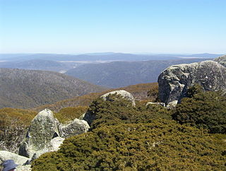
The Brindabella Range, commonly called The Brindabellas or The Brindies, is a mountain range located in Australia, on a state and territory border of New South Wales and the Australian Capital Territory (ACT). The range rises to the west of Canberra, the capital city of Australia, and includes the Namadgi National Park in the ACT and the Bimberi Nature Reserve and Brindabella National Park in New South Wales. The Brindabellas are visible to the west of Canberra and form an important part of the city's landscape.

The Guadalupe Mountains are a mountain range located in West Texas and southeastern New Mexico. The range includes the highest summit in Texas, Guadalupe Peak, 8,751 ft (2,667 m), and the "signature peak" of West Texas, El Capitan, both of which are located within Guadalupe Mountains National Park. The Guadalupe Mountains are bordered by the Pecos River valley and Llano Estacado to the east and north, Delaware Mountains to the south, and Sacramento Mountains to the west. One of the clearest exposures of a prehistoric reef is preserved in the mountain range's bedrock geology. Bedrock contains fossils of reef-dwelling organisms from the Permian period, and the geology is widely studied, mostly by stratigraphers, paleontologists, and Paleoecologists.

Serpentine soil is an uncommon soil type produced by weathered ultramafic rock such as peridotite and its metamorphic derivatives such as serpentinite. More precisely, serpentine soil contains minerals of the serpentine subgroup, especially antigorite, lizardite, and chrysotile or white asbestos, all of which are commonly found in ultramafic rocks. The term "serpentine" is commonly used to refer to both the soil type and the mineral group which forms its parent materials.

Páramo may refer to a variety of alpine tundra ecosystems located in the Andes Mountain Range, South America. Some ecologists describe the páramo broadly as "all high, tropical, montane vegetation above the continuous timberline". A narrower term classifies the páramo according to its regional placement in the northern Andes of South America and adjacent southern Central America. The páramo is the ecosystem of the regions above the continuous forest line, yet below the permanent snowline. It is a "Neotropical high mountain biome with a vegetation composed mainly of giant rosette plants, shrubs and grasses". According to scientists, páramos may be "evolutionary hot spots", meaning that it's among the fastest evolving regions on Earth.

James L. Nelson is an American historical nautical novelist.

The Valle Vidal is a 101,794 acres (41,195 ha) mountain basin in the Sangre de Cristo Mountains within the Carson National Forest, northwest of Cimarron, New Mexico. Elevations in the basin range from 7,700 to 12,554 feet. Valle Vidal is noted for its pristine scenery and wildlife. It was protected from oil and gas exploitation by an act of Congress in 2006. The Valle Vidal borders on Vermejo Park Ranch, Philmont Scout Ranch, and other private lands.

Ammophila arenaria is a species of grass in the family Poaceae. It is known by the common names marram grass and European beachgrass. It is one of two species of the genus Ammophila. It is native to the coastlines of Europe and North Africa where it grows in the sands of beach dunes. It is a perennial grass forming stiff, hardy clumps of erect stems up to 1.2 metres (3.9 ft) in height. It grows from a network of thick rhizomes which give it a sturdy anchor in its sand substrate and allow it to spread upward as sand accumulates. These rhizomes can grow laterally by 2 metres in six months. One clump can produce 100 new shoots annually.
Douglas Whynott is an American writer who has written five critically acclaimed books of narrative nonfiction. The subjects of his books range from migratory commercial beekeepers and the beekeeping industry, to the bluefin tuna fishery in New England, a boatyard in Maine, a veterinary clinic in New Hampshire, and the maple syrup industry. In his early years Whynott worked as a dolphin trainer, fish curator, piano tuner, apiary inspector, track coach, and blues piano player.

Urocystis agropyri is a fungal plant pathogen that causes flag smut on wheat.

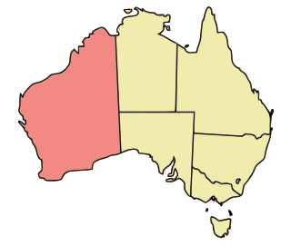
Western Australia occupies nearly one third of the Australian continent. Due to the size and the isolation of the state, considerable emphasis has been made of these features; it is the second largest administrative territory in the world, after Yakutia in Russia, despite the fact that Australia is only the sixth largest country in the world by area, and no other regional administrative jurisdiction in the world occupies such a high percentage of a continental land mass.

Wetland conservation is aimed at protecting and preserving areas of land including marshes, swamps, bogs, and fens that are covered by water seasonally or permanently due to a variety of threats from both natural and anthropogenic hazards. Some examples of these hazards include habitat loss, pollution, and invasive species. Wetland vary widely in their salinity levels, climate zones, and surrounding geography and play a crucial role in maintaining biodiversity, ecosystem services, and support human communities. Wetlands cover at least six percent of the Earth and have become a focal issue for conservation due to the ecosystem services they provide. More than three billion people, around half the world's population, obtain their basic water needs from inland freshwater wetlands. They provide essential habitats for fish and various wildlife species, playing a vital role in purifying polluted waters and mitigating the damaging effects of floods and storms. Furthermore, they offer a diverse range of recreational activities, including fishing, hunting, photography, and wildlife observation.

The Western world, also known as the West, primarily refers to various nations and states in the regions of Western Europe, Northern America, and Australasia; with some debate as to whether those in Eastern Europe and Latin America also constitute the West. The Western world likewise is called the Occident in contrast to the Eastern world known as the Orient. The West is considered an evolving concept; made up of cultural, political, and economic synergy among diverse groups of people, and not a rigid region with fixed borders and members. Definitions of "Western world" vary according to context and perspectives.
Philmont Scout Ranch is located in the Sangre de Cristo Mountains of the Rocky Mountains of New Mexico. Philmont is about 12 miles (19 km) across at its widest point, and about 30 miles (48 km) long. The southern part of the ranch is mostly grasslands/prairie, while the north is rocky and rugged, but a small part of the eastern area is prairie.

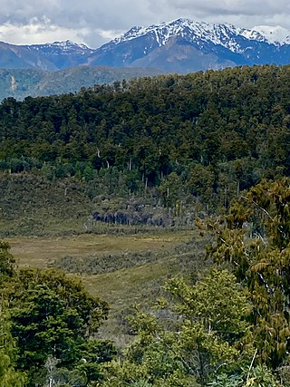
Pakihi or pākihi is a vegetation association unique to the West Coast of the South Island of New Zealand, characterised by flat boggy land with infertile, waterlogged soil on which only rushes, ferns, moss, and mānuka grow.


