Cowra Prisoner of War Camp Site | |
---|---|
Ruins of the prisoner-of-war-camp, 2011 | |
Location | Evans Street, Cowra, Cowra Shire, New South Wales, Australia |
Coordinates | 33°48′55″S148°42′23″E / 33.8153°S 148.7064°E |
Built | 1941–1944 |
Owner | Cowra Shire Council |
Official name | Cowra Prisoner of War Camp Site; POW |
Type | state heritage (archaeological-terrestrial) |
Designated | 2 April 1999 |
Reference no. | 619 |
Type | Internment Camp |
Category | Law Enforcement |
Builders | Australian soldiers and POWs |
Cowra Prisoner of War Camp Site is a heritage-listed former prisoner-of-war camp at Evans Street, Cowra in the Central West region of New South Wales, Australia. The camp was built from 1941 to 1944. It was the location of the infamous Cowra breakout in 1944. The property is owned by the Cowra Shire Council. It was added to the New South Wales State Heritage Register on 2 April 1999. [1]
The Cowra Prisoner of War Camp was constructed in 1941-42 to house Italian POWs captured by Allied Forces during World War II. It was part of a nationwide system of POW confinement and enemy alien containment. In all, twenty-eight major camps were established in Australia by the British Military Board during this period. The camp was to consist of four compounds, two with permanent amenities and two temporary. Although officially operating from June 1941, the first internees were marched into Cowra nearly four months later, on 15 October 1941. The major building program was still underway at this time and was not completed until well into 1944. Both POW and local labourers were used to complete construction, the prisoners living in tents until April 1942 when accommodation huts became available. [1]
By December 1942 over 2,000 mainly Italian, prisoners and internees were housed in the camp. Between January 1943 and August 1944, over one thousand Japanese POWs and internees arrived. By the end of June 1944 the camp was already overcrowded beyond its intended capacity. At 2 am on 5 August 1944 the Japanese prisoners staged an outbreak, during which over 300 escaped outright and over 250 died. 18 buildings were burnt to the ground. This action has remained significant in popular memory as the first time the War was fought on home soil and as the largest revolt of its kind in Australia's history. This has often overshadowed the experience of the Italian, Javanese and assorted other ethnic groups which populated the camp during its operation. [1]
After the end of the War the camp and its surrounds were sold to the New South Wales Department of Agriculture and a private owner. Part of the site remains within a public reserve. The private part of the site is used for grazing and crop cultivation. [2] [1]
In 1991, Cherry Tree Avenue was extended across the camp to link with the War Cemetery and the Cowra Japanese Garden and Cultural Centre. [1]
The camp is located on gently sloping land that is separated from the town by a ridge line. The camp generally exists in a cleared setting although there has been considerable tree growth in and around many of the structural remains. None of the original perimeter or internal fences, paths or structures remain to any appreciable level above ground level, although remnants of floor slabs, footings and drainage lines have been identified using aerial photographs. A single ruinous, but above ground structure is located at the north western end of the Headquarters area. It comprises four walls constructed from a variety of materials including stone rubble, salvaged bricks and concrete blocks. Evidence of a relatively shallow-pitched roof remains. Two buildings remain intact off site, having been sold at auction after the camp was disbanded. They are 60' by 80' timber huts with corrugated asbestos pitched roofs. [3] [1]
Few of the former facilities survive to any great extent above ground level. The archaeological potential is extremely high in all areas of the complex. The site is not well preserved, with few of the original features remaining above ground. It does however have an intact archaeological resource. This, and the extensive documentary resource add significantly to its interpretive and historical potential. [1]
The Cowra POW camp-site exists within a landscape that is both evocative and aesthetically pleasing. This landscape may be used to interpret the context of the camp as the site's primary historical feature, because it remains essentially the way it was during WWII. [1]
The site is one component of a national body of evidence which documents the most profound physical impact of WWII on Australian soil. It also represents the only land engagement on the Australian mainland during that period. [1]
The camp-site has a wide ethnic and multi-cultural association and was instrumental in the decisions of many families to migrate to Australia after WWII. The site has a particular cultural and spiritual significance to the Japanese nation, as it was the focus of the break-out and loss of life of Japanese prisoners. Links formed between Cowra and Japan have been instrumental in affecting the form, direction and identity of the town in the post-war period. This situation is unique in Australia. [4] [1]
Cowra Prisoner of War Camp Site was listed on the New South Wales State Heritage Register on 2 April 1999 having satisfied the following criteria. [1]
The place is important in demonstrating the course, or pattern, of cultural or natural history in New South Wales.
The development and occupation of the Prisoner of War camp was unique in the region, has important historical associations and has had a profound effect on the post-war development of Cowra. It represents a profound physical impact of WWII on Australian soil. The site can also be used to interpret the modified rural landscape in which it exists. The activities of the Agricultural Research Station have had a profound influence upon the district as a whole. [5] [1]
The place is important in demonstrating aesthetic characteristics and/or a high degree of creative or technical achievement in New South Wales.
The landscape surrounding the site may be used to interpret the context of the camp as the site's primary historical feature, because it remains essentially the way it was during WWII. The pleasing and spacious environment is particularly evocative of both the conditions within the camp during its life and its post-war history. The intrusive tree and shrub growth however, are seen to detract from the significance of the place by obscuring the interpretation of the site as an open space and masking many of the ruins. [6] [1]
The place has strong or special association with a particular community or cultural group in New South Wales for social, cultural or spiritual reasons.
The camp was not the first nor the largest POW campsite in Australia. Neither is it the best preserved. There is however, a substantial body of archaeological and documentary evidence that enables this site as part of a national body of evidence to demonstrate the POW experience of WWII in Australia. It is important for ethnic and multi-cultural experience in Australia. It has an association with the Japanese breakout, which has military significance. As the site on which many Japanese lives were lost it also has cultural and spiritual significance for the Japanese nation. Finally, the events which occurred at the site have initiated a profound impact on the form and cultural activity of Cowra in the post-war years. This is an event and process which is apparently unique in Australia. [7] [1]
The place has potential to yield information that will contribute to an understanding of the cultural or natural history of New South Wales.
The physical remnants that remain in-situ represent a technology and building method for an architectural typology which is relatively rare in Australia and which existed for a short time and for a specific purpose. The physical and archaeological resources represent a database that could be used to more accurately examine the habits and lifestyle of both the guards and the prisoners within the camp. [8] [1]
The place is important in demonstrating the principal characteristics of a class of cultural or natural places/environments in New South Wales.
The site is not the first, largest or most intact POW camp. There is however, a substantial body of archaeological and documentary evidence that enables it, as part of a national body of evidence, to demonstrate the POW experience of WWII in Australia. [1]
The Scheyville National Park is a protected national park that is located in the northwestern suburbs of Sydney in New South Wales, in eastern Australia. The 920-hectare (2,300-acre) national park is situated approximately 40 kilometres (25 mi) northwest of the Sydney central business district, northeast of Windsor, near the settlement of Scheyville. Longneck Lagoon lies in the northern section of the park. It was added to the New South Wales State Heritage Register on 9 April 2010.
Hay is a town in the western Riverina region of south western New South Wales, Australia. It is the administrative centre of Hay Shire local government area and the centre of a prosperous and productive agricultural district on the wide Hay Plains.
Cowra is a small town in the Central West region of New South Wales, Australia. It is the largest population centre and the council seat for the Cowra Shire, with a population of 9,863.
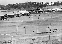
The Cowra Breakout occurred on 5 August 1944, when 1,104 Japanese prisoners of war escaped from a POW camp near Cowra, in New South Wales, Australia. It was the largest prison escape of World War II, as well as one of the bloodiest. During the escape and ensuing manhunt, four Australian soldiers were killed and 231 Japanese soldiers were killed or committed suicide. The remaining escapees were re-captured and imprisoned.
RAAF Base Rathmines is a heritage-listed former RAAF Second World War seaplane base and now used as community venues, sports venues and a visitor attraction at Dorrington Road, Rathmines, City of Lake Macquarie, New South Wales, Australia. It was in use as an RAAF base from 1939 to 1961. It is also known as Rathmines Park, former RAAF Seaplane Base, Flying Boat Base, Rathmines Aerodrome and Catalina Base. The property is owned by Australian Christadelphian Bible School, Disability Life Enrichment, Don Geddes Nursing Home and Lake Macquarie City Council. The remains of the former air base was added to the New South Wales State Heritage Register on 25 November 2005.
Trial Bay Gaol is a heritage-listed former public works prison and internment camp at Cardwell Street, Arakoon, Kempsey Shire, New South Wales, Australia. The property is owned by the NSW National Parks and Wildlife Service. It was added to the New South Wales State Heritage Register on 14 May 2010.
Featherston prisoner of war camp was a camp for captured Japanese soldiers during World War II at Featherston, New Zealand, notorious for a 1943 incident in which 48 Japanese and one New Zealander were killed. The camp had been established during World War I as a military training camp and had also been used as an internment camp from 1918 to 1920, when 14 German internees remained there.
The Hay Gaol is a heritage-listed former prison and now museum at 355 Church Street, Hay, Hay Shire, New South Wales, Australia. It was an adult prison from 1880 to 1915 and 1930 until 1940, a prisoner-of-war camp during World War II, and a juvenile facility, the Hay Institution for Girls, from 1961 to 1974. It was designed by James Barnet and Colonial Architect and built from 1879 to 1880 by Witcombe Brothers. The site faces Church Street, and is otherwise bounded by Piper, Macauley and Coke Streets, north-east of the town centre. It was added to the New South Wales State Heritage Register on 13 March 2009.
Batu Lintang camp at Kuching, Sarawak on the island of Borneo was a Japanese-run internment camp during the Second World War. It was unusual in that it housed both Allied prisoners of war (POWs) and civilian internees. The camp, which operated from March 1942 until the liberation of the camp in September 1945, was housed in buildings that were originally British Indian Army barracks. The original area was extended by the Japanese, until it covered about 50 acres. The camp population fluctuated, due to movement of prisoners between camps in Borneo, and as a result of the deaths of the prisoners. It had a maximum population of some 3,000 prisoners.
No. 208 Radar Station RAAF is a heritage-listed former Royal Australian Air Force (RAAF) radar station at Mine Camp at Catherine Hill Bay and Pinny Beach, both in City of Lake Macquarie, New South Wales, Australia. It was established on 10 February 1943. The remains of the radar station were added to the New South Wales State Heritage Register on 22 July 2008.
The Dawes Point Battery remains is a heritage-listed former artillery fortification and now visitor attraction located adjacent to the southern pylon of the Sydney Harbour Bridge at Hickson Road in inner city Sydney, on the boundary between Dawes Point and The Rocks in the City of Sydney local government area of New South Wales, Australia. It was built and modified from 1791 to 1925 by Lieutenant William Dawes, Robert Ross, Francis Greenway, and George Barney. The property is owned by Property NSW, an agency of the Government of New South Wales. It was added to the New South Wales State Heritage Register on 10 May 2002.
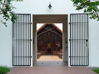
The Changi Chapel and Museum is a war museum dedicated to Singapore's history during the Second World War and the Japanese occupation of Singapore. After the British Army was defeated by the Imperial Japanese Army in the Battle of Singapore, thousands of prisoners of war (POWs) were imprisoned in Changi prison camp for three and a half years. While interned there, the POWs built numerous chapels, one of which was named St George's Church.
Loveday is a town and locality in the Riverland region of South Australia, located east of the Moorook Game Reserve, 6 km south-west of Barmera, and 30 km north-west of Loxton. Administratively it is part of the Berri Barmera Council LGA. During World War II, it housed the largest internment camp complex in Australia, with some 5,000 detainees.
Honouliuli National Historic Site is near Waipahu on the island of Oahu, in the U.S. state of Hawaii. This is the site of the Honouliuli Internment Camp which was Hawaiʻi's largest and longest-operating internment camp, opened in 1943 and closed in 1946. It was designated a National monument on February 24, 2015, by President Barack Obama. The John D. Dingell, Jr. Conservation, Management, and Recreation Act, signed March 12, 2019, redesignated it as Honouliui National Historic Site. The internment camp held 320 internees and also became the largest prisoner of war camp in Hawaiʻi with nearly 4,000 individuals being held. Of the seventeen sites that were associated with the history of internment in Hawaiʻi during World War II, the camp was the only one built specifically for prolonged detention. As of 2015, the new national monument is without formal services and programs.
Petty Officer Hajime Toyoshima was a Japanese airman in World War II. His A6M Zero was the first of that type to be recovered relatively intact on Allied territory when he crash landed on Melville Island, Northern Territory, Australia.
The Hay Internment and POW camps at Hay, New South Wales, Australia were established during World War II as prisoner-of-war and internment centres, due in part to the isolated location of the town. Three high-security camps were constructed in 1940. The first arrivals were 2,542 internees from Nazi Germany and Austria, most of whom were Jewish; they had been interned in the United Kingdom as enemy aliens when the possibility of an Axis invasion of Britain was at its highest.
The Cowra Breakout is a 1984 Australian mini series based on the Cowra breakout, focusing on the friendship between an Australian soldier and Japanese prisoner.
The Hive Shipwreck is a heritage-listed shipwreck site of the Hive, a former convict transportation ship located approximately 40 metres (130 ft) off Bherwerre Beach, Jervis Bay Territory, Australia. It was added to the New South Wales State Heritage Register on 1 April 2010.
Italian prisoners of war in Australia were Italian soldiers captured by the British and Allied Forces in World War II and taken to Australia.
Berrima Internment Camp Huts Area is a heritage-listed former internment camp site at Argyle Street, Berrima, in the Southern Highlands of New South Wales, Australia. It formed an additional section of the former Berrima Internment Camp outside the walls of the Berrima Gaol. It was established from 1915 to 1918. The camp was also known as the Berrima PoW Camp, the German Detention Camp and the German Concentration Camp. It was added to the New South Wales State Heritage Register on 14 January 2011.
This Wikipedia article was originally based on Cowra Prisoner of War Camp Site , entry number 00619 in the New South Wales State Heritage Register published by the State of New South Wales (Department of Planning and Environment) 2018 under CC-BY 4.0 licence , accessed on 2 June 2018.
Media related to Cowra POW camp at Wikimedia Commons