Related Research Articles
Reeves County is a county located in the U.S. state of Texas. As of the 2020 census, its population was 14,748. Its county seat and most populous city is Pecos. The county was created in 1883 and organized the next year. It is named for George R. Reeves, a Texas state legislator and colonel in the Confederate Army. It is one of the nine counties that comprise the Trans-Pecos region of West Texas. Reeves County comprises the Pecos micropolitan statistical area.

Pecos County is a county located in the U.S. state of Texas. As of the 2020 census, its population was 15,193. The county seat is Fort Stockton. The county was created in 1871 and organized in 1875. It is named for the Pecos River. It is one of the nine counties that comprise the Trans-Pecos region of West Texas.

Carlsbad is a city in and the county seat of Eddy County, New Mexico, United States. As of the 2020 census, the city population was 32,238. Carlsbad is centered at the intersection of U.S. Routes 62/180 and 285, and is the principal city of the Carlsbad-Artesia Micropolitan Statistical Area, which has a total population of 62,314. Located in the southeastern part of New Mexico, Carlsbad straddles the Pecos River and sits at the eastern edge of the Guadalupe Mountains.

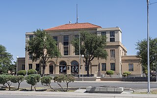
Pecos is the largest city in and the county seat of Reeves County, Texas, United States. It is in the valley on the west bank of the Pecos River at the eastern edge of the Chihuahuan Desert, in the Trans-Pecos region of West Texas and just south of New Mexico's border. Its population was 12,916 at the 2020 census. On January 24, 2012, Pecos City appeared on the Forbes 400 as the second-fastest growing small town in the United States. The city is a regional commercial center for ranching, oil and gas production, and agriculture. The city is most recognized for its association with the local cultivation of cantaloupes. Pecos claims to be the site of the world's first rodeo on July 4, 1883.

The Pecos River originates in north-central New Mexico and flows into Texas, emptying into the Rio Grande. Its headwaters are on the eastern slope of the Sangre de Cristo mountain range in Mora County north of Pecos, New Mexico, at an elevation of over 12,000 feet (3,700 m). The river flows for 926 miles (1,490 km) before reaching the Rio Grande near Del Rio. Its drainage basin encompasses about 44,300 square miles (115,000 km2).

The Big Bend is part of the Trans-Pecos region in southwestern Texas, United States along the border with Mexico, north of the prominent bend in the Rio Grande for which the region is named. Here the Rio Grande passes between the Chisos Mountains in Texas and the Sierra Madre Oriental in Mexico as it changes from running east-southeast to north-northeast. The region covers three counties: Presidio County to the west, Brewster County to the east, and Jeff Davis County to the north.

West Texas is a loosely defined region in the U.S. state of Texas, generally encompassing the arid and semiarid lands west of a line drawn between the cities of Wichita Falls, Abilene, and Del Rio.
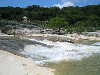
The Pedernales River is a tributary of the Colorado River, approximately 106 miles (171 km) long, in Central Texas in the United States. It drains an area of the Edwards Plateau, flowing west to east across the Texas Hill Country west of Austin. The name "Pedernales", first used in the middle 18th century, comes from a Spanish word for the flint rocks characteristic of the riverbed.
Pecos may refer to:

The Trans-Pecos, as originally defined in 1887 by the Texas geologist Robert T. Hill, is the distinct portion of Texas that lies west of the Pecos River. The term is considered synonymous with Far West Texas, a subdivision of West Texas. The Trans-Pecos is part of the Chihuahuan Desert, the largest desert in North America. It is the most mountainous and arid portion of the state, and most of its vast area is sparsely populated. Among the nine counties in the region are the five largest counties by area in Texas and eight of the eleven largest in the state. The area is known for the natural environment of the Big Bend and the gorge of the Rio Grande, part of which has been designated a National Wild and Scenic Rivers System. With the notable exceptions of Big Bend Ranch State Park, Big Bend National Park and the Guadalupe Mountains National Park, the vast majority of the Trans-Pecos region consists of privately owned ranchland. However, most of the region's population reside in the El Paso metropolitan area. Besides El Paso and its metropolitan area, the major cities are Pecos (12,916), Fort Stockton (8,466), and Alpine (6,035). All other settlements have under 5,000 people.

Eastern New Mexico is a physiographic subregion within the U.S. state of New Mexico. The region is sometimes called the "High Plains," or "Eastern Plains ," and was historically referred to as part of the "Great American Desert". The region is largely coterminous with the portion of the Llano Estacado in New Mexico. Portions of Eastern New Mexico's elevation extend to over 4,000 ft (1,200 m). The region is characterized by flat, largely featureless terrain with the exception of the Pecos River valley and the abrupt breaks along the Mescalero Ridge and northern caprock escarpments of the Llano Estacado. The region typically lacks the high relief of central and northern New Mexico, such as that in the Sangre de Cristo and Sandia mountain ranges. The climate is semi-arid with hot summers and is characterized by significant wind and dust storms in the springtime.

The Delaware River (Texas) or Delaware Creek is an intermittent stream that rises in Guadalupe Mountains National Park about 8 km (5.0 mi) west of Pine Springs and 3 km (1.9 mi) north of Guadalupe Peak in northwestern Culberson County, Texas. It flows into the Pecos River in New Mexico, 5 km (3.1 mi) north of the border with Texas.
Howard Draw is a valley that heads in the extreme south of Reagan County, Texas at an elevation of 2720 feet at 30°05′09″N101°22′27″W, and runs through Crockett County to its foot on the Pecos River in Val Verde County, elevation 1575 feet.
Monument Draw is either of two ephemeral streams that rise in New Mexico and flow into Texas. Both take their name from Monument Springs, three miles (5 km) west-northwest of Monument, New Mexico. One rises four miles (6 km) west of Monument Springs and flows generally south into the Pecos River. The other rises 11 miles (18 km) east of Monument Springs and south of Hobbs, New Mexico, and flows generally east-southeast to join with Seminole Draw to form Mustang Draw, which then flows generally south to then form Beals Creek, which ultimately flows into the Colorado River of Texas.

Running Water Draw is an ephemeral watercourse about 150 mi (240 km) long, heading about 24 mi (39 km) west-northwest of Clovis, New Mexico, and trending generally east-southeast, into Texas, to join Callahan Draw at the head of the White River about 9 mi (14 km) west of Floydada and 34 mi (55 km) northeast of Lubbock.
Salt Draw is a river in Texas. On April 4, 2004 flash flooding of Salt Draw caused the failure of a protective levee around Toyah, Texas, extensive flooding of most homes and property in Toyah, and the destruction of the Interstate 20 bridge over Salt Draw between Toyah and Pecos, Texas in Reeves County. Indirectly, 5 lives were also lost in a weather related traffic accident on U.S. Route 285 south of Pecos, which was being used as a detour because of the bridge failure.
Tunas Creek formerly known as Arroyo Escondido, is a stream tributary to the Pecos River, in Pecos County, Texas. Its source is at 30°52′53″N102°34′59″W on the southwestern side of Big Mesa.
Pecos Canyon, is a tributary of the Devils River in Val Verde County, Texas. It has its source at 30°16′17″N101°09′13″W, 8.6 miles north northwest of Juno, Texas.
Lancaster Crossing, also known as Indian Ford, Pecos Crossing, Solomon's Ford, Crossing of the Pecos, Crossing Rio Pecos, Ferry of the Pecos, and Ford Canyon Crossing, is an historic ford and ferry on the Pecos River, between Crockett County and Pecos County just southeast of Sheffield, Texas. Named after nearby Fort Lancaster, it is one of the few natural fords on the Pecos River, otherwise known for its steep banks that made crossing difficult.
References
- "An Analysis of Texas Waterways" . Retrieved 2006-05-04.
- USGS Geographic Names Information Service
- USGS Hydrologic Unit Map - State of Texas (1974)
| | This article related to a river in Texas is a stub. You can help Wikipedia by expanding it. |