
Cressday
Location of Cressday, Alberta
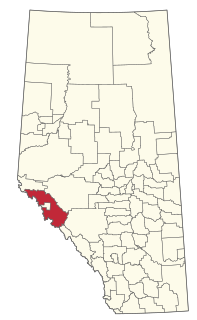
Cressday is a locality in Alberta, Canada. [1]
The locality's name is an amalgamation of the surnames of W. Cresswell and Tony Day, cattlemen. [2]
Cressday is a locality in Alberta, Canada. [1]
The locality's name is an amalgamation of the surnames of W. Cresswell and Tony Day, cattlemen. [2]

Sturgeon County is a municipal district the Edmonton Metropolitan Region of Alberta, Canada. It is north of Edmonton and east of the North Saskatchewan River. Sturgeon County is located in Division No. 11 and was named for the Sturgeon River.

Foothills County is a municipal district in southern Alberta, Canada adjacent to the south side of Calgary in Census Division No. 6. Despite sharing a common border with the City of Calgary, it does not form part of the Calgary census metropolitan area (CMA) as defined by Statistics Canada. It is however a member municipality of the Calgary Metropolitan Region Board.

Clearwater County is a municipal district in west central Alberta, Canada in Division No. 9. Its northwest boundary is the Brazeau River. The municipal office is located in the Town of Rocky Mountain House. The county has a land area of 18,691.65 km2 and comprises close to 99% of Census Division No. 9's land area of 18,921.38 km2. Although the territory excluded is rather small in geographical area, it comprises the major population centre of Rocky Mountain House, which has one-third of Division No. 9's population, in addition to the communities of Caroline, Burnstick Lake and three Indian reserves. The county's 2016 census population was 11,947.

Starland County is a municipal district located in southern Alberta, Canada.

Yellowhead County is a municipal district in west central Alberta, Canada. It is the only municipal district within Alberta census division No. 14.

Lethbridge County is a municipal district in southern Alberta, Canada. It is in Census Division No. 2 and part of the Lethbridge census agglomeration. It was known as the County of Lethbridge prior to December 4, 2013. Its name was changed in time for 2014 to coincide with its 50th anniversary.

Beaver County is a municipal district in central-east Alberta, Canada. It is centred on Holden in the western part of Census Division No. 10. Its municipal office is located in Ryley.

Birch Hills County is a municipal district in north-western Alberta, Canada. It is located in Census Division 19, northeast of Grande Prairie.

Cardston County is a municipal district in southern Alberta, Canada. It is located in Census Division 3 around the Town of Cardston.

Lac Ste. Anne County is a municipal district in central Alberta, Canada.

The Municipal District of Lesser Slave River No. 124 is a municipal district (MD) in north-central Alberta, Canada. Its municipal office is located in the Town of Slave Lake. Located in Census Division 17, the MD takes its name from Lesser Slave River, which drains Lesser Slave Lake into the Athabasca River.

The County of Wetaskiwin No. 10 is a municipal district in central Alberta, Canada that is south of Edmonton. Located in Census Division No. 11, its municipal office is in located in the City of Wetaskiwin.
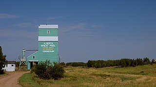
Kirriemuir is hamlet in east-central Alberta, Canada within Special Area No. 4. It is located on Highway 12, approximately 12 kilometres (7.5 mi) west of Altario. It has an elevation of 730 metres (2,400 ft).
Bindloss is a hamlet in southern Alberta, Canada within Special Area No. 2. It is located approximately 10 kilometres (6.2 mi) west of Highway 41 and 97 kilometres (60 mi) north of Medicine Hat.
Cessford is a hamlet in southern Alberta, Canada within Special Area No. 2. It is located approximately 22 kilometres (14 mi) east of Highway 36 and 54 kilometres (34 mi) northeast of Brooks.
Chinook is a hamlet in southern Alberta, Canada within Special Area No. 3. It is located on Highway 9 approximately 119 kilometres (74 mi) northeast of Brooks.
Dorothy is a hamlet in southern Alberta, Canada within Special Area No. 2. It is located approximately 21 kilometres (13 mi) east of Highway 56 and 85 kilometres (53 mi) northwest of Brooks.
Iddesleigh is a hamlet in southern Alberta, Canada within Special Area No. 2. It is located approximately 37 kilometres (23 mi) northeast of Highway 1 and 46 kilometres (29 mi) northeast of Brooks.
Improvement District No. 12 , or Improvement District No. 12, is an improvement district in Alberta, Canada. Coextensive with Jasper National Park in Alberta's Rockies, the improvement district is the municipality that provides local government for the portion of the park outside the Municipality of Jasper.
| | This Southern Alberta location article is a stub. You can help Wikipedia by expanding it. |