In aviation, a critical area refers to a designated area of an airport that all aircraft, vehicles, persons or physical obstructions must remain clear of when one or more Instrument Landing Systems (ILS) are in use, to protect against signal interference or attenuation that may lead to navigation errors, or accident. Critical areas also protect the ILS system's internal monitoring[clarification needed].
ILS technology delivers two main types of information to pilots. These types include the glideslope (vertical location relative to the designed glide path) and the localizer (lateral position relative to the designed approach course). Each type of information is broadcast using a separate antenna array and each type has a specific critical area:
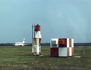
Sign placed at edge of ILS critical area (often next to pavement markings)
Localizer critical area – aircraft/vehicles/persons or physical obstructions are not authorized in or over the critical area when an arriving aircraft is between the ILS final approach fix and the airport.
Glideslope critical area – aircraft/vehicles/persons or physical obstructions are not authorized in or over the critical area when an arriving aircraft is between the ILS final approach fix and the airport unless the aircraft has reported the airport in sight and is circling or sidestepping to land on a runway other than the ILS runway.
For practical purposes, these two areas are combined into the ILS critical area and identified by signs and pavement markings.
During times of reduced ceilings and visibility (800ft/2miles) or during ILS autoland (coupled) approaches pilots are expected to:
Before takeoff – stop aircraft before entering the critical area while waiting for takeoff.
After landing – move the aircraft out of the critical area before stopping to receive taxi instructions from the ground controller.
Much larger than the critical area is the sensitive area. Aircraft and vehicles are not allowed in this area when low visibility procedures are in force, since aircraft autoland during this time and therefore the accuracy of the guidance signals provided by the ILS is absolutely critical.
Multipathing is a potential error in the ILS system, which may affect the glideslope and/or the localizer. This occurs when the radio signals reaching the aircraft are distorted because a large metal object moves into the radiation zone of the transmitter, such as when an aircraft is flying ahead or a taxiing aircraft or truck enters the ILS critical area.
Related Research Articles
In aviation, instrument flight rules (IFR) is one of two sets of regulations governing all aspects of civil aviation aircraft operations; the other is visual flight rules (VFR).
In aviation, the instrument landing system (ILS) is a precision radio navigation system that provides short-range guidance to aircraft to allow them to approach a runway at night or in bad weather. In its original form, it allows an aircraft to approach until it is 200 feet (61 m) over the ground, within a 1⁄2 mile (800 m) of the runway. At that point the runway should be visible to the pilot; if it is not, they perform a missed approach. Bringing the aircraft this close to the runway dramatically increases the range of weather conditions in which a safe landing can be made. Other versions of the system, or "categories", have further reduced the minimum altitudes, runway visual ranges (RVRs), and transmitter and monitoring configurations designed depending on the normal expected weather patterns and airport safety requirements.
An autopilot is a system used to control the path of a vehicle without requiring constant manual control by a human operator. Autopilots do not replace human operators. Instead, the autopilot assists the operator's control of the vehicle, allowing the operator to focus on broader aspects of operations.
A taxiway is a path for aircraft at an airport connecting runways with aprons, hangars, terminals and other facilities. They mostly have a hard surface such as asphalt or concrete, although smaller general aviation airports sometimes use gravel or grass.
The Wide Area Augmentation System (WAAS) is an air navigation aid developed by the Federal Aviation Administration to augment the Global Positioning System (GPS), with the goal of improving its accuracy, integrity, and availability. Essentially, WAAS is intended to enable aircraft to rely on GPS for all phases of flight, including precision approaches to any airport within its coverage area. It may be further enhanced with the Local Area Augmentation System (LAAS) also known by the preferred ICAO term Ground-Based Augmentation System (GBAS) in critical areas.
A precision approach path indicator (PAPI) is a system of lights on the side of an airport runway threshold that provides visual descent guidance information during final approach. It is generally located on the left-hand side of the runway approximately 300 metres (980 ft) beyond the landing threshold of the runway.
In aviation, an instrument approach or instrument approach procedure (IAP) is a series of predetermined maneuvers for the orderly transfer of an aircraft operating under instrument flight rules from the beginning of the initial approach to a landing, or to a point from which a landing may be made visually. These approaches are approved in the European Union by EASA and the respective country authorities and in the United States by the FAA or the United States Department of Defense for the military. The ICAO defines an instrument approach as "a series of predetermined maneuvers by reference to flight instruments with specific protection from obstacles from the initial approach fix, or where applicable, from the beginning of a defined arrival route to a point from which a landing can be completed and thereafter, if landing is not completed, to a position at which holding or en route obstacle clearance criteria apply."
In aviation, autoland describes a system that fully automates the landing procedure of an aircraft's flight, with the flight crew supervising the process. Such systems enable airliners to land in weather conditions that would otherwise be dangerous or impossible to operate in.
The microwave landing system (MLS) is an all-weather, precision radio guidance system intended to be installed at large airports to assist aircraft in landing, including 'blind landings'. MLS enables an approaching aircraft to determine when it is aligned with the destination runway and on the correct glidepath for a safe landing. MLS was intended to replace or supplement the instrument landing systems (ILS). MLS has a number of operational advantages over ILS, including a wider selection of channels to avoid interference with nearby installations, excellent performance in all weather, a small "footprint" at the airports, and wide vertical and horizontal "capture" angles that allowed approaches from wider areas around the airport.
In aviation, the runway visual range (RVR) is the distance over which a pilot of an aircraft on the centreline of the runway can see the runway surface markings delineating the runway or the lights delineating the runway or identifying its centre line. RVR is normally expressed in meters or feet. RVR is used to determine the landing and takeoff conditions for aircraft pilots, as well as the type of operational visual aids used at the airport.
Crossair Flight 3597 was a scheduled flight from Berlin Tegel Airport, Germany, to Zürich Airport, Switzerland. On 24 November 2001, the Crossair Avro RJ100 or BAE Systems 146 operating the route, registered as HB-IXM, crashed into a wooded range of hills near Bassersdorf and caught fire. Out of the 33 occupants, nine survived.
A marker beacon is a particular type of VHF radio beacon used in aviation, usually in conjunction with an instrument landing system (ILS), to give pilots a means to determine position along an established route to a destination such as a runway.
The local-area augmentation system (LAAS) is an all-weather aircraft landing system based on real-time differential correction of the GPS signal. Local reference receivers located around the airport send data to a central location at the airport. This data is used to formulate a correction message, which is then transmitted to users via a VHF Data Link. A receiver on an aircraft uses this information to correct GPS signals, which then provides a standard instrument landing system (ILS)-style display to use while flying a precision approach. The FAA has stopped using the term LAAS and has transitioned to the International Civil Aviation Organization (ICAO) terminology of ground-based augmentation system (GBAS). While the FAA has indefinitely delayed plans for federal GBAS acquisition, the system can be purchased by airports and installed as a Non-Federal navigation aid.
A transponder landing system (TLS) is an all-weather, precision landing system that uses existing airborne transponder and instrument landing system (ILS) equipment to create a precision approach at a location where an ILS would normally not be available.
Augmentation of a global navigation satellite system (GNSS) is a method of improving the navigation system's attributes, such as precision, reliability, and availability, through the integration of external information into the calculation process. There are many such systems in place, and they are generally named or described based on how the GNSS sensor receives the external information. Some systems transmit additional information about sources of error, others provide direct measurements of how much the signal was off in the past, while a third group provides additional vehicle information to be integrated in the calculation process.
In aviation, a ground-controlled approach (GCA) is a type of service provided by air-traffic controllers whereby they guide aircraft to a safe landing, including in adverse weather conditions, based on primary radar images. Most commonly, a GCA uses information from either a precision approach radar or an airport surveillance radar. The term GCA may refer to any type of ground radar guided approach such as a PAR, PAR without glideslope or ASR. When both vertical and horizontal guidance from the PAR is given, the approach is termed a precision approach. If no PAR glidepath is given, even if PAR equipment is used for lateral guidance, it is considered a non-precision approach.
Western Airlines Flight 2605, nicknamed the "Night Owl", was an international scheduled passenger flight from Los Angeles, California, to Mexico City, Mexico. On October 31, 1979, at 5:42 a.m. CST (UTC−06:00), the McDonnell Douglas DC-10 used on the flight crashed at Mexico City International Airport in fog after landing on a runway that was closed for maintenance. Of the 88 occupants on board, 72 were killed, in addition to a maintenance worker who died when the plane struck his vehicle.
Aviastar-TU Flight 1906 was a Tupolev Tu-204 that crashed while attempting to land at Domodedovo International Airport, Moscow, Russia, in heavy fog on 22 March 2010. The aircraft was on a ferry flight from Hurghada International Airport, Egypt to Moscow, and had no passengers on board; all eight crew survived the accident, four with serious injuries requiring hospitalization and four with minor injuries. The accident was the first hull loss of a Tu-204 and the first hull loss for Aviastar-TU.
Union Island Airport is the airport serving Union Island, Grenadines Parish, Saint Vincent and the Grenadines. It is located about 0.25 miles (0.40 km) from the town of Clifton, one of the country's main tourist centers and a major destination for charter leisure flights during the winter holiday season and Easter, for "Easterval" celebration. The airport serves as a focus city for flag carrier SVG Air and features flights to several short-haul regional destinations. It is the southmost airport of St. Vincent and the Grenadines.
The Blind Landing Experimental Unit, abbreviated BLEU, was a unit of the British government tasked with creating an early autolanding system for military and civilian aircraft from the late 1940s until the mid-1960s.
This page is based on this Wikipedia article Text is available under the CC BY-SA 4.0 license; additional terms may apply. Images, videos and audio are available under their respective licenses.