Related Research Articles
Ardleigh Green is an area in east London, England, within the London Borough of Havering. It is 15.5 miles (25 km) east-northeast of Charing Cross. This part of London is predominantly residential.
Milbury Heath is a hamlet in South Gloucestershire, England, located east of Thornbury. The hamlet has a garden centre and a few other farm shops. The heath is a local high point and offers views west across the Severn Vale, and north into the Vale of Berkeley. A seat at the viewpoint commemorates the centenary of Falfield Parish Council in 1994. The hamlet has a former (Methodist?) chapel now converted to a private house, and a duck-pond.

Bromham is a village and civil parish in Wiltshire, England. The village is 3+1⁄2 miles (6 km) northwest of Devizes and the same distance east of Melksham.

Manningtree is a town and civil parish in the Tendring district of Essex, England, which lies on the River Stour. It is part of the Suffolk Coast and Heaths Area of Outstanding Natural Beauty.

Romford is a constituency in Greater London represented in the House of Commons of the UK Parliament since 2001 by Andrew Rosindell, a Conservative.
Bristol Community Church is a charismatic church located in Kingswood, Bristol, England.
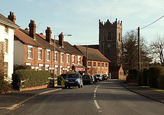
Ardleigh is a village and civil parish in Essex, England. It is situated approximately 4 miles (6 km) northeast from the centre of Colchester and 26 miles (42 km) northeast from the county town of Chelmsford.

Harwich and North Essex is a constituency represented in the House of Commons of the UK Parliament by Bernard Jenkin of the Conservative Party since its creation in 2010.

Smallthorne is an area in the city of Stoke-on-Trent in Staffordshire, England. It is in the north-east of the city, near Burslem. Smallthorne borders Bradeley and Chell in the north, Norton-in-the-Moors in the east, Sneyd Green in the south, and Burslem in the west.
Little Bromley is a village and civil parish in the Tendring district of Essex, England. The name "Bromley" is Old English for "broomy wood/clearing". The village lies 9 kilometres (6 mi) east northeast of Colchester and 3 kilometres (2 mi) south of Manningtree. It is surrounded by the parishes of Lawford, Ardleigh, Great Bromley, Little Bentley, and Mistley. Its area is about 7.5 square kilometres. The population was reported to be 426 in the 1841 census, 361 in the 1911 census, 289 in the 2001 census, and 253 in the 2011 census. The main economic activity is arable farming. The village shop, mentioned in Kelly's Directory of Essex (1914), ceased operating in the 1990s.

Lea is a village in Wiltshire, England, lying approximately 1.5 miles (2.4 km) east of Malmesbury. It is part of the civil parish of Lea and Cleverton which includes the village of Garsdon and the hamlet of Cleverton. Garsdon was a separate parish until 1934.
Great Somerford is a village and civil parish within Dauntsey Vale, Wiltshire, England, near the south bank of the river Avon. It lies approximately 3+1⁄4 miles (5.2 km) southeast of Malmesbury and 12 miles (19 km) west of Swindon. The hamlet of Startley and the area known as Seagry Heath are within the bounds of the parish.

Chorlton is a village and former civil parish, now in the parish of Hough and Chorlton, in the unitary authority area of Cheshire East and the ceremonial county of Cheshire, England. The village lies 4 miles (6.4 km) to the south east of Crewe. Nearby villages include Hough, Shavington, Weston and Wybunbury in Cheshire and Betley in Staffordshire. In 2011 the parish had a population of 897.
Sound is a hamlet and civil parish in the unitary authority of Cheshire East and the ceremonial county of Cheshire, England. The hamlet is located 3+1⁄4 miles (5.2 km) to the south west of Nantwich. The civil parish covers 1,089 acres (441 ha) and also includes the small settlements of Newtown and Sound Heath, with a total population at the 2011 census of 239. Nearby villages include Aston, Ravensmoor and Wrenbury.
The Surrey Chapel (1783–1881) was an independent Methodist and Congregational church established in Blackfriars Road, Southwark, London on 8 June 1783 by the Rev. Rowland Hill. His work was continued in 1833 by the Congregational pastor Rev. James Sherman, and in 1854 by Rev. Newman Hall. The chapel's design attracted great interest, being circular in plan with a domed roof. When built it was set in open fields, but within a few years it became a new industrial area with a vast population characterised by great poverty amidst pockets of wealth. Recently the site itself has been redeveloped as an office block, and Southwark Underground Station has been built opposite.

Church Broughton is a village and civil parish in Derbyshire, 13.7 miles (22.0 km) to the west of Derby. It has a church and a Methodist chapel (1828). Badway Green is a piece of common land within the parish. It is an isolated village surrounded by farmland.
Ellerdine is a small hamlet located six miles north of the market town of Wellington, Shropshire.
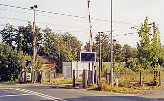
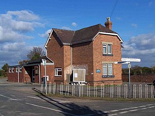
Ardleigh railway station served the village of Ardleigh in Essex, England. The station was situated on the Great Eastern Main Line.

Ardleigh Gravel Pit is a 1.2-hectare (3.0-acre) geological Site of Special Scientific Interest south of Ardleigh in Essex. It is a Geological Conservation Review site.

Blofield Heath is a hamlet in the civil parish of Blofield, in the Broadland district, in the county of Norfolk, England. It is about 7 miles from Norwich. In 2020 it had an estimated population of 1488. Blofield Heath has a post office and it formerly had a primitive Methodist Chapel. Blofield Heath is separated from Blofield village by the A47.
References
- ↑ Tendring District Council and Colchester City Council, "Crockleford Heath and Environs: Character Appraisal Plan" (2023). Retrieved 15 January 2025.
- ↑ Kelly's Directory, Essex, 1917
- ↑ Ardleigh's Past, Crockleford School
- ↑ The Primitive Methodist Magazine, 1859, p.560
51°53′49″N0°57′54″E / 51.897°N 0.965°E
| | This Essex location article is a stub. You can help Wikipedia by expanding it. |