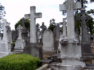
Glasnevin Cemetery is a large cemetery in Glasnevin, Dublin, Ireland which opened in 1832. It holds the graves and memorials of several notable figures, and has a museum.

Theobald Wolfe Tone, posthumously known as Wolfe Tone, was a revolutionary exponent of Irish independence and is an iconic figure in Irish republicanism. Convinced that so long as his fellow Protestants feared to make common cause with the Catholic majority, the British Crown would continue to govern Ireland in the interest of England and of its client aristocracy, in 1791 Tone helped form the Society of United Irishmen. Although received in the company of a Catholic delegation by the King and his ministers in London, Tone, with other United Irish leaders, despaired of constitutional reform. Fuelled by the popular grievances of rents, tithes and taxes, and driven by martial-law repression, the society developed as an insurrectionary movement. When, in the early summer of 1798, it broke into open rebellion, Tone was in exile soliciting assistance from the French Republic. In October 1798, on his second attempt to land in Ireland with French troops and supplies, he was taken prisoner. Sentenced to be hanged, he died from a reportedly self-inflicted wound.

John Behan is an Irish sculptor from Dublin.
The Society of United Irishmen was a sworn association, formed in the wake of the French Revolution, to secure representative government in Ireland. Despairing of constitutional reform, and in defiance both of British Crown forces and of Irish sectarian division, in 1798 the United Irishmen instigated a republican rebellion. Their suppression was a prelude to the abolition of the Irish Parliament in Dublin and to Ireland's incorporation in a United Kingdom with Great Britain.

The Irish Rebellion of 1798 was a popular insurrection against the British Crown in what was then the separate, but subordinate, Kingdom of Ireland. The main organising force was the Society of United Irishmen. First formed in Belfast by Presbyterians opposed to the landed Anglican establishment, the Society, despairing of reform, sought to secure a republic through a revolutionary union with the country's Catholic majority. The grievances of a rack-rented tenantry drove recruitment.
Kilmainham is a south inner suburb of Dublin, Ireland, south of the River Liffey and west of the city centre. It is in the city's Dublin 8 postal district.
Inchicore is a suburb of Dublin, Ireland. Located approximately 5 kilometres (3.1 mi) west of the city centre, Inchicore was originally a small village separate from Dublin. The village developed around Richmond Barracks and Inchicore railway works, before being incorporated into the expanding city bounds. Inchicore is a largely residential area and is home to the association football club St Patrick's Athletic FC.
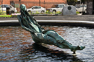
Anna Livia is a bronze monument located in Croppies' Acre Memorial Park in Dublin, Ireland. It was formerly located on O'Connell Street.
Croppy was a nickname given to United Irishmen rebels during the Irish Rebellion of 1798 against British rule in Ireland.

Island Bridge, formerly Sarah or Sarah's Bridge, is a road bridge spanning the River Liffey, in Dublin, Ireland which joins the South Circular Road to Conyngham Road at the Phoenix Park.

Bodenstown Graveyard is a cemetery located in County Kildare, Republic of Ireland. Containing a ruined medieval church, it is best known as the burial place of the Irish patriot Wolfe Tone (1763–1798).

The R115 road is a regional road in counties Dublin and Wicklow in Ireland. It follows the Military Road for its entire length. The R115 is 40.5 km (25.2 mi) long; the full length of the Military Road is 57.9 km (36.0 mi).

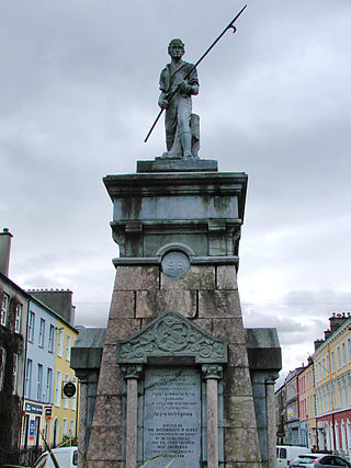
Bartholomew Teeling was an Irish military officer and nationalist who was the leader of the rebel forces during the Irish Rebellion of 1798 and who carried out an act of bravery during the Battle of Collooney. He was captured at the Battle of Ballinamuck and subsequently executed for treason.

Arbour Hill Prison is a prison located in the Arbour Hill area near Heuston Station in the centre of Dublin, Ireland. The prison is the national centre for male sex offenders.
Carrickbrennan Churchyard located on Carrickbrennan Road, Monkstown, County Dublin, Ireland is a graveyard that can still be seen today, but is no longer in use. It is notable as the burial place of many people who perished in local maritime disasters. The graveyard stands beside the grounds of Monkstown Park, former estate of Lord Ranelagh and latterly the historian Charles Haliday, now used as rugby pitches by CBC Monkstown Park.

Grangegorman Military Cemetery is a British military cemetery in Dublin, Ireland, located on Blackhorse Avenue, parallel to the Navan Road and beside the Phoenix Park.

Arbour Hill is an area of Dublin within the inner city on the Northside of the River Liffey, in the Dublin 7 postal district. Arbour Hill, the road of the same name, runs west from Blackhall Place in Stoneybatter, and separates Collins Barracks, now hosting part of the National Museum of Ireland, to the south from Arbour Hill Prison to the north, whose graveyard includes the burial plot of the signatories of the Easter Proclamation and other leaders executed after the 1916 Rising. St Bricin's Military Hospital, formerly the King George V Hospital, is also located in Arbour Hill.

Museum is a stop on the Luas light-rail tram system in Dublin, Ireland. It opened in 2004 as a stop on the Red Line. The stop is located between Croppies' Acre and the National Museum of Ireland – Decorative Arts and History. It also provides access to the Arbour Hill Prison. It has two edge platforms. Northbound trams leave the stop and travel east through the streets of Dublin city centre to Connolly or The Point. Southbound trams leave the stop and turn left, crossing the River Liffey on Seán Heuston Bridge, before calling at Heuston on their way to Tallaght or Saggart.


