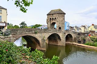
Monnow Bridge, in Monmouth, Wales, is the only remaining fortified river bridge in Great Britain with its gate tower standing on the bridge. Such bridge towers were common across Europe from medieval times, but many were destroyed due to urban expansion, diminishing defensive requirements and the increasing demands of traffic and trade. The historical and architectural importance of the bridge and its rarity are reflected in its status as a scheduled monument and a Grade I listed building. The bridge crosses the River Monnow 500 metres (1,600 ft) above its confluence with the River Wye.

Raglan (; is a village and community in Monmouthshire, south east Wales, United Kingdom. It is located some 9 miles south-west of Monmouth, midway between Monmouth and Abergavenny on the A40 road very near to the junction with the A449 road. The fame of the village derives from Raglan Castle, built for William ap Thomas and now maintained by Cadw. The community includes the villages of Llandenny and Pen-y-clawdd. Raglan itself has a population of 1,183.
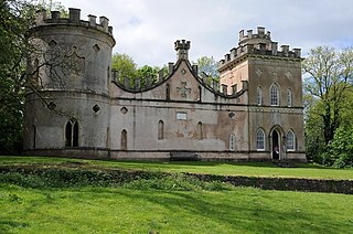
Clytha Castle is a folly near Clytha between Llanarth and Raglan in Monmouthshire, south east Wales. Dating from 1790, the castle was built by William Jones, owner of the Clytha Park estate as a memorial to his wife, Elizabeth, who died in 1787. The castle is an example of the Gothic Revival and comprises three towers, of which two are habitable, and linking, castellated curtain walls. Long attributed to John Nash, recent research has confirmed that the architect was John Davenport of Shrewsbury. The folly has views towards the Sugar Loaf and Skirrid mountains on the easternmost edge of the Brecon Beacons National Park. Described by the architectural historian John Newman as one of the two "outstanding examples of late eighteenth century fanciful Gothic in the county", Clytha Castle is a Grade I listed building.

Llantilio Crossenny is a small village and much larger former community, now in the community of Whitecastle, in Monmouthshire, south east Wales, in the United Kingdom. It is situated between the two towns of Abergavenny and Monmouth on the B4233 road. The community included Penrhos, and Llanvihangel-Ystern-Llewern.

Llanarth Court is a late-18th-century country house with substantial 19th-century alterations in Llanarth, Monmouthshire, Wales. The court was built for the Jones family of Treowen and was subsequently the home of Ivor Herbert, 1st Baron Treowen, whose family still owns much of the Llanarth estate, although not the court itself. The court is a Grade II* listed building and is now a private hospital. The gardens are included on the Cadw/ICOMOS Register of Parks and Gardens of Special Historic Interest in Wales.
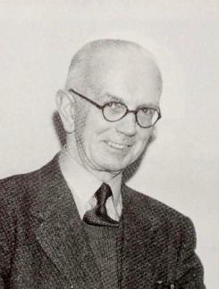
Frederick James Hando MBE was a Welsh writer, artist and schoolteacher from Newport. He chronicled the history, character and folklore of Monmouthshire, which he also called Gwent, in a series of nearly 800 newspaper articles and several books published between the 1920s and 1960s.

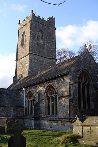
St Cadoc's Church, Raglan, Monmouthshire, south east Wales, is the parish church of the village of Raglan. The church is situated at a cross-roads in the centre of the village. Built originally by the Clare and Bluet families in the thirteenth and fourteenth centuries, it was rebuilt, and expanded by the Herbert's of Raglan Castle in the fifteenth century. In the nineteenth century, the church was subject to a major restoration by Thomas Henry Wyatt.

Monmouthshire is a county and principal area of Wales. It borders Torfaen and Newport to the west; Herefordshire and Gloucestershire to the east; and Powys to the north. The largest town is Abergavenny, with the other major towns being Chepstow, Monmouth, and Usk. The county is 850 km2 in extent, with a population of 95,200 as of 2020. The present county was formed under the Local Government (Wales) Act 1994, which came into effect in 1996, and comprises some sixty percent of the historic county. Between 1974 and 1996, the county was known by the ancient title of Gwent, recalling the medieval Welsh kingdom. In his essay on local government in the fifth and final volume of the Gwent County History, Robert McCloy suggests that the governance of "no county in the United Kingdom in the twentieth century was so transformed as that of Monmouthshire".

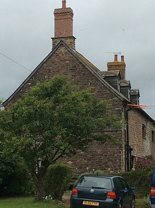
St Cenedlon's is a parish church in the village of Rockfield, Monmouthshire, Wales. The dedication to St Cenedlon is unusual and the history of the saint is obscure. Some sources suggest that she was a daughter of Brychan king of Brycheiniog while others identify her as the wife of King Arthfael ab Ithel, king of Glywysing. The existing church dates from the Middle Ages but only the tower remains from that period. After the English Reformation, the surrounding area of north Monmouthshire became a refuge for Catholics and Matthew Pritchard (1669-1750), Roman Catholic bishop and Vicar Apostolic of the Western District is buried at the church. By the mid-19th century the church was in ruins and a complete reconstruction was undertaken by the ecclesiastical architects John Pollard Seddon and John Prichard in around 1860. St Cenedlon's is an active parish church in the Diocese of Monmouth. It is designated by Cadw as a Grade II listed building.
St Tewdric's Church is a Church in Wales parish church in Mathern, Monmouthshire, Wales. It is purportedly built over the resting place of Saint Tewdrig for whom it is named. A church has been located on the site since the 6th century. It was reconstructed by the Normans in the Early English style, and later was renovated by the Victorians. It is a Grade I listed building.
Tŷ Mawr in Dingestow, Monmouthshire is a complex of farm buildings dating from 1640. The farmhouse and attached barn are listed Grade II*. The gatehouse to the farm has a separate Grade II* listing.

The Church of the Holy Cross, Kilgwrrwg, Monmouthshire, Wales, is an early medieval parish church that once supported a now abandoned village. A Grade II* listed building, the church remains an active parish church and is part of the Severn Wye Ministry Area.
The Artha, Tregare, Monmouthshire is a farmhouse dating from the mid-17th century. It is a Grade II* listed building.

The Old Cottage, in the hamlet of Treadam, some 2km north-west of Llantilio Crossenny, Monmouthshire, is a country house dating from c.1600. The house is Grade II* listed.

Old Trecastle Farmhouse, Pen-y-clawdd, Monmouthshire is a farmhouse, originally, a gentry house, dating from the 16th and 17th centuries. It stands on the site of the outworks of a Norman motte-and-bailey castle. The house is Grade II* listed.

Treworgan Manor, Llansoy, Monmouthshire is a country house dating from the early 18th century. Its origins are older, from the 16th century. Long in the possession of the Prichard family, it changed hands a number of times in later centuries and remains a private residence. The house is Grade II* listed, its listing describing it as a "fine Renaissance house". An adjacent barn has its own Grade II Listing.

Ton Farmhouse, Llangybi, Monmouthshire is a farmhouse dating from the early 17th century. John Newman, in his Monmouthshire Pevsner, describes it as a "perfect Monmouthshire farmhouse". Ton is a Grade II* listed building, its listing noting that it is a "remarkably good survival" of a prosperous 17th century Welsh farmhouse.

Wern-ddu farmhouse, Llantilio Pertholey, Monmouthshire is a farmhouse of 17th century origins. It has been significantly altered in the 18th, 19th and 20th centuries and the Monmouthshire antiquarian, Sir Joseph Bradney recorded that it had "suffered so much by continual alterations that it shows but little of its antiquity". It is a Grade II* listed building.

Berllan-deg, Llanhennock, Monmouthshire is a country house dating from the mid-17th century. A rare survival of a remarkably unaltered hall house, Berllan-deg is a Grade II* listed building.

Perth-hir House, Rockfield, Monmouthshire, Wales, was a major residence of the Herbert family. It stood at a bend of the River Monnow, to the north-west of the village. At its height in the 16th century, the mansion, entered by two drawbridges over a moat, comprised a great hall and a number of secondary structures. Subsequently in the ownership of the Powells, and then the Lorimers, the house became a centre of Catholic recusancy following the English Reformation. By the 19th century, the house had declined to the status of a farmhouse and it was largely demolished in around 1830. Its ruins, and the site which contains considerable remnants of a Tudor garden, are a scheduled monument.

