Cullahill Castle

Last updated

Cullahill Castle, April 2009. Cullohill Castle.jpg
Cullahill Castle, April 2009.

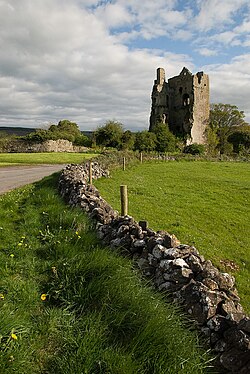
Cullahill Castle was the principal stronghold of the MacGillapatricks of Upper Ossory built around 1425 and destroyed around 1650. Cullahill Castle takes its name from an ancient forest that covered Cullahill Mountain and extended down to Cullahill village.

Contents

Location

In the village of Cullahill in County Laois, Ireland. Approximately 100 metres out on the road up the nearby hill that gives the area its name.

History

Built around 1425, probably by Finghin MacGillapatrick

Reportedly came under attack on several occasions by the "sovereign and citizens of Kilkenny" under reward from King Henry VI. Such attacks were reported in 1441 and 1517. [1]

It was attacked and partially destroyed by Cromwell's forces around 1650. It was probably attacked by cannon from a nearby hill.

It was recorded as "ruinous and uninhabitated" in 1657.

Structure

It is a tower-house rising to five storeys. Most of the northern portion, including the doorway, is missing. It is vaulted above the ground floor and has mural passages and chambers. A straight mural stairway rises to the upper levels. There are remains of mullioned windows at the higher floors of the castle.

The castle has a Sheela na Gig mounted on the outer wall behind the chimney.

Across the road lies the ruins of its chapel which was the private chapel of the Catholic lords of Upper Ossory.

Related Research Articles

<span class="mw-page-title-main">County Kilkenny</span> County in Ireland

County Kilkenny is a county in Ireland. It is in the province of Leinster and is part of the Southern Region. It is named after the city of Kilkenny. Kilkenny County Council is the local authority for the county. At the 2022 census the population of the county was 103,685. The county was based on the historic Gaelic kingdom of Ossory (Osraighe), which was coterminous with the Diocese of Ossory.

<span class="mw-page-title-main">County Laois</span> County in Ireland

County Laois is a county in Ireland. It is part of the Eastern and Midland Region and in the province of Leinster. It was known as Queen's County from 1556 to 1922. The modern county takes its name from Loígis, a medieval kingdom. Historically, it has also been known as County Leix.

<span class="mw-page-title-main">Dunamase</span> Historic site in County Laois, Ireland

Dunamase or the Rock of Dunamase is a rocky outcrop in County Laois, Ireland. Rising 46 metres (151 ft) above a plain, it has the ruins of Dunamase Castle, a defensive stronghold dating from the early Hiberno-Norman period with a view across to the Slieve Bloom Mountains. It is near the N80 road between the towns of Portlaoise and Stradbally.

<span class="mw-page-title-main">Rathdowney</span> Village in Leinster, Ireland

Rathdowney or Rathdowny is a town in southwest County Laois, Ireland. It lies some 32 km southwest of Portlaoise in the Irish Midlands, at the point where the R433 regional road from Abbeyleix to Templemore is crossed by the R435 from Borris-in-Ossory to Johnstown. The R433 provides access for Rathdowney to the Dublin-Cork M8 motorway, while the R435 links the town to the Dublin-Limerick M7. As of the 2016 census, the population of Rathdowney was 1,271.

<span class="mw-page-title-main">Orford Castle</span> Grade I listed historic house museum in Suffolk Coastal, United Kingdom

Orford Castle is a castle in Orford in the English county of Suffolk, 12 miles (19 km) northeast of Ipswich, with views over Orford Ness. It was built between 1165 and 1173 by Henry II of England to consolidate royal power in the region. The well-preserved keep, described by historian R. Allen Brown as "one of the most remarkable keeps in England", is of a unique design and probably based on Byzantine architecture. The keep stands within the earth-bank remains of the castle's outer fortifications.

<span class="mw-page-title-main">Ballaghmore, County Laois</span> Village with castle in County Laois, Ireland

Ballaghmore is a small village located on the western side of County Laois, Ireland, southwest of Portlaoise. It is approximately 7 kilometres (4 mi) east of Roscrea. The village is in the civil parish of Kyle in the historic barony of Clandonagh.

<span class="mw-page-title-main">Duffield Castle, Derbyshire</span>

Duffield Castle was a Norman Castle in Duffield, Derbyshire. The site is a Scheduled Ancient Monument.

<span class="mw-page-title-main">Osraige</span> Medieval southeastern Irish kingdom

Osraige or Osraighe, Osraí, anglicized as Ossory, was a medieval Irish kingdom comprising what is now County Kilkenny and western County Laois, corresponding to the Diocese of Ossory. The home of the Osraige people, it existed from around the first century until the Norman invasion of Ireland in the 12th century. It was ruled by the Dál Birn dynasty, whose medieval descendants assumed the surname Mac Giolla Phádraig.

<span class="mw-page-title-main">Ardvreck Castle</span>

Ardvreck Castle is a castle, now ruinous, standing on a rocky promontory in Loch Assynt, Sutherland, Scotland, UK. The structure dates from about 1490 and is associated with the then landowners, the Macleods of Assynt.

<span class="mw-page-title-main">Palcho Monastery</span> Tibetan Buddhist monastery in Gyantse, Tibet, China

The Palcho Monastery or Pelkor Chode Monastery or Shekar Gyantse is the main monastery in the Nyangchu river valley in Gyantse, Gyantse County, Shigatse Prefecture, Tibet Autonomous Region. The monastery precinct is a complex of structures which, apart from the Tsuklakhang Monastery, also includes its Kumbum, believed to be the largest such structure in Tibet, that is most notable for its 108 chapels in its several floors and the old Dzong or fort.

<span class="mw-page-title-main">Durrow, County Laois</span> Village in County Laois, Ireland

Durrow is a village located in south-east County Laois, Ireland. Bypassed by the M8 motorway on 28 May 2010, the village is located on the R639 road at its junction with the N77. The River Erkina flows through Durrow and joins the River Nore about 1.5 km east of the village.

<span class="mw-page-title-main">Cullohill</span> Village in Leinster, Ireland

Cullahill or Cullohill is a small village situated on the R639 road in County Laois, Ireland. Cullahill takes its name from an ancient forest that covered Cullahill Mountain and extended down to Cullahill Castle.

<span class="mw-page-title-main">R639 road (Ireland)</span> Road in Ireland

The R639 road is one of Ireland's regional roads. Once designated the N8 national primary road, it was reclassified in stages as the R639 following the progressive opening of sections of the M8 motorway, which rendered the single carriageway N8 redundant as a national primary road. By-passed sections of the old N8 were generally reclassified as R639 as soon as a new section of M8 opened, thereby increasing the length of the R639. With the completion of the M8 on 28 May 2010, the R639 now stretches from Durrow, County Laois to Cork, running through counties Laois, Kilkenny, Tipperary, Limerick and Cork.

<span class="mw-page-title-main">Tourbillon Castle</span> Castle in Sion, Switzerland

Tourbillon Castle is a castle in Sion in the canton of Valais in Switzerland. It is situated on a hill and faces the Basilique de Valère, located on the opposite hill.

<span class="mw-page-title-main">Upper Ossory</span> Barony in County Laois, Ireland

Upper Ossory was an administrative barony in the south and west of Queen's County in Ireland. In late Gaelic Ireland it was the túath of the Mac Giolla Phádraig (Fitzpatrick) family and a surviving remnant of the once larger kingdom of Ossory. The northernmost part of the Diocese of Ossory and medieval County Kilkenny, it was transferred to the newly created Queen's County, now known as County Laois, in 1600. In the 1840s its three component cantreds, Clarmallagh, Clandonagh, and Upperwoods, were promoted to barony status, thereby superseding Upper Ossory.

<span class="mw-page-title-main">Pfäffikon Castle</span>

Pfäffikon Castle is a castle in the municipality of Freienbach of the Canton of Schwyz in Switzerland. It is a Swiss heritage site of national significance.

The Abbey of Aghaboe is one of the most important of the abbeys and priories in County Laois. It was founded in the kingdom of Osraige by St. Canice in the 6th century. In his Vita Sancti Columbae, Adomnán refers to the abbey, saying that its name means a of the cow: "quod Latine Campulus Bovis dicitur, Scotice vero Achadh-bou"

<span class="mw-page-title-main">Irishtown, Kilkenny</span> Neighbourhood within the historic city of Kilkenny

<span class="mw-page-title-main">St. Mary's Collegiate Church, Gowran</span> Church in County Kilkenny, Ireland

St. Mary’s Collegiate Church Gowran, also known as the Church of the Blessed Virgin of the Assumption, is a church in the centre of the town of Gowran, County Kilkenny, Ireland. The site is a National Monument in the care of the Gowran Development Association (GDA) and the Office of Public Works (OPW). The church and its family connections have been of huge importance to Gowran and further afield over the centuries. The church is a collegiate church, which means that the priests or chaplains attached to it lived in community together. The present church was not a monastery or an abbey; however experts believe the church was built on the site of an earlier monastery. The presence of an Ogham stone on the site, which is on display in the chancel, suggests there was a place of worship here dating back 2000 years to Celtic times or beyond.

<span class="mw-page-title-main">Mac Giolla Phádraig dynasty</span> Descendants of the former kings of Osraige

Mac Giolla Phádraig is a native Irish dynastic surname which translates into English as "Son of the Devotee of (St.) Patrick". In the medieval period, the Mac Giolla Phádraigs were hereditary kings of Osraige; today, the anglicised version of the name is commonly "Fitzpatrick".

References

  1. Carrigan, William (1905). The history and antiquities of the diocese of Ossory (Volume 2). Sealy, Bryers & Walker. pp. 231–233.

52°48′58″N7°28′22″W / 52.8162°N 7.4729°W / 52.8162; -7.4729