
Hume Highway, inclusive of the sections now known as Hume Freeway and Hume Motorway, is one of Australia's major inter-city national highways, running for 840 kilometres (520 mi) between Melbourne in the southwest and Sydney in the northeast. Upgrading of the route from Sydney's outskirts to Melbourne's outskirts to dual carriageway was completed on 7 August 2013.

Redfern is an inner southern suburb of Sydney located 3 kilometres (1.9 mi) south of the Sydney central business district and is part of the local government area of the City of Sydney. Strawberry Hills is a locality on the border with Surry Hills. The area experienced the process of gentrification and is subject to extensive redevelopment plans by the state government, to increase the population and reduce the concentration of poverty in the suburb and neighbouring Waterloo.

Upper Lachlan Shire is a local government area in the Southern Tablelands region of New South Wales, Australia. The Shire was formed in February 2004 from Crookwell Shire and parts of Mulwaree, Gunning and Yass Shires.

Casino is a town in the Northern Rivers area of New South Wales, Australia, with a population of 10,914 people at the 2016 census. It lies on the banks of the Richmond River and is situated at the junction of the Bruxner Highway and the Summerland Way.

Stanmore is a suburb in the Inner West of Sydney, in New South Wales, Australia 6 kilometres south west of the Sydney central business district. It is part of the local government area of the Inner West Council. It is known for its long strip of shops running along Parramatta Road.

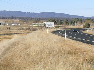
Breadalbane is a small village located in the Southern Tablelands of New South Wales, Australia in Upper Lachlan Shire. It is located on the Lachlan River headwaters and not far from Goulburn. At the 2021 census, Breadalbane had a population of 107.

Dalton is a small inland country town in the Southern Tablelands of New South Wales, Australia, in Upper Lachlan Shire. The population was 230 in the 2021 census.

Henty is a town in southwestern New South Wales close to the boundaries of the South West Slopes and the Riverina districts, almost midway between the regional cities of Albury and Wagga Wagga. At the 2006 census, Henty had a population of 863 people.

Menangle is a village in the Macarthur region of New South Wales, Australia.

Morven is a small village about 7 kilometres east of Culcairn in the eastern Riverina district of New South Wales, Australia. At the 2021 census, Morven has a population of 125 people.

Wangi Power Station is a heritage-listed former coal-fired power station at Wangi Wangi, City of Lake Macquarie, New South Wales on Lake Macquarie. The power station operated between 1956 and 1986 and supplied electricity to New South Wales. It was once the largest in the state. The 12,000 square-metre building was listed on the New South Wales State Heritage Register on 2 April 1999.
Cockle Creek Power Station was located in Teralba, New South Wales, Australia on the banks of Cockle Creek. The power stationed operated from 11 March 1927 until March 1976.

Cullerin is a small township in the Southern Tablelands of New South Wales, Australia. It is on the Old Hume Highway and Main South railway line in Upper Lachlan Shire. The Cullerin railway station opened in 1880 and closed in 1973. At the 2016 census, it had a population of 38.
Dundee is a rural locality about 40 kilometres north of Glen Innes on the Northern Tablelands, New South Wales, Australia. It is situated on the New England Highway at the Severn River in Severn parish, Gough County, New South Wales. The elevation is 985 metres.
Grafton railway station is a railway station on the North Coast line in South Grafton, Clarence Valley Council, New South Wales, Australia. It serves the city of Grafton, opening on 12 October 1915 as South Grafton when the line opened from Glenreagh. It was renamed Grafton City on 1 October 1976 when the original Grafton station north of the Clarence River closed. Since 2005, it has again been known as Grafton Station.

The 30 megawatt Cullerin Range Wind Farm is located in the localities of Cullerin and Breadalbane in the Upper Lachlan Shire, New South Wales, Australia. The wind farm was completed in 2009 and cost around $90 million. The owner, Origin Energy, sold the business to Energy Developments, a subsidiary of Duet.
Kembla Grange is a suburb west of Berkeley, in the City of Wollongong. At the 2016 census, it had a population of 252.

Chakola is a locality in the Snowy Monaro Region, New South Wales, Australia. It lies on both sides of the Murrumbidgee River and both sides of the Numeralla River. It also lies on both sides of the Monaro Highway about 100 km south of Canberra and about 25 km north of Cooma. At the 2016 census, it had a population of 47.

Bunyan is a locality in the Snowy Monaro Region, New South Wales, Australia. It lies on the eastern side of the Murrumbidgee River and on both sides of the Monaro Highway about 110 km south of Canberra and about 10 km north of Cooma. At the 2016 census, it had a population of 152.
