
Cummings Township is a township in Lycoming County, Pennsylvania, United States. The population was 355 at the 2000 census. It is part of the Williamsport, Pennsylvania Metropolitan Statistical Area. Cummings Township is home to two of the 120 Pennsylvania state parks, Little Pine State Park and Upper Pine Bottom State Park.
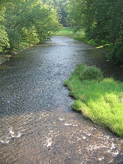
Little Pine Creek is a tributary of Pine Creek in Lycoming County, Pennsylvania, in the United States. It is approximately 15.8 miles (25.4 km) long and flows through Pine Township and Cummings Township.
Bill Cummings nicknamed "Wild Bill", won the 1934 Indianapolis 500. Cummings died driving a passenger automobile on State Road 29 in Indianapolis, when he hit a guard rail and plunged 50 feet (15 m) into Lick Creek. Cummings was pulled from the water by passers-by while still alive, but died in the hospital two days later.

Franklin Creek State Natural Area is an Illinois state park on 664 acres (269 ha) in Lee County, Illinois, United States. Franklin Creek State Natural Area was dedicated in 1982, making it the 24th nature preserve in Illinois.
Eagle Creek State Park is an Illinois state park on 11,100 acres (4,492 ha)Lake Shelbyville, and is approx 34,000 acres in Shelby County, Illinois, United States.
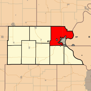
Shannon Township is a township in Atchison County, Kansas, United States. As of the 2010 census, its population was 1,282.

Coyote Creek is a principal tributary of the San Gabriel River in northwest Orange County, southeast Los Angeles County, and southwest Riverside County, California. It drains a land area of roughly 41.3 square miles (107 km2) covering five major cities, including Brea, Buena Park, Fullerton, La Habra, and La Palma. Some major tributaries of the creek in the highly urbanized watershed include Brea Creek, Fullerton Creek, and Carbon Creek. The mostly flat creek basin is separated by a series of low mountains, and is bounded by several small mountain ranges, including the Chino Hills, Puente Hills and West Coyote Hills.

Cummings is an unincorporated community in Mendocino County, California. It is located near U.S. Route 101 on Rattlesnake Creek 5 miles (8 km) east-southeast of Leggett, at an elevation of 1329 feet.
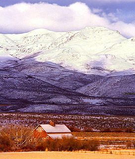
The Owyhee Mountains are a mountain range in Owyhee County, Idaho and Malheur County, Oregon.
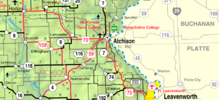
Cummings is an unincorporated community in Atchison County, Kansas, United States. Cummings is 9.5 miles (15.3 km) southwest of Atchison. Cummings has a post office with ZIP code 66016.
The Canajoharie Creek flows into the Mohawk River in the village of Canajoharie, New York. The name "Canajoharie" is said to be a Mohawk language term meaning "the pot that washes itself," referring to the "Canajoharie Boiling Pot," a circular gorge in the Canajoharie Creek, just south of the village of Canajoharie, New York.
The Nowadaga Creek basin drains portions of the towns of Danube, Stark, and Little Falls, as well as a small portion of the town of Warren, in southern Herkimer County before converging with the Mohawk River in Indian Castle, New York. The drainage basin is approximately 49 percent forested. The creek has an average slope of 1.7 percent over its entire stream length of 10.0 miles. On a 1790 land patent map it is spelled "Inchanando Creek".
Moyer Creek starts at Wheelock Pond near Jerusalem Hill, New York. Past Gulph, New York Moyer Creek follows a deep ravine, the Frankfort Gorge, south towards Frankfort, New York before converging with the Mohawk River in Frankfort, New York. The headwaters of Moyer Creek rise within a half mile of the source of the Unadilla River which is the most northerly headwater source of the Susquehanna and the closest to the Mohawk River.
The Caroga Creek starts at the East Caroga Lake and flows south passing through Rockwood Lake before converging with the Mohawk River in Palatine Church, New York.
The Cobleskill Creek starts at the mouth of the Schenevus Creek in Richmondville, New York. It flows through Cobleskill, New York before converging with the Schoharie Creek in Central Bridge, New York.

The Schenevus Creek is a river located in southern Otsego County, New York. The creek flows through Worcester and Schenevus before converging with the Susquehanna River in Colliersville, New York.
Panther Mountain is a mountain located in Central New York of New York near Fly Creek, New York and Schuyler Lake, New York. The east side of Panther Mountain drains into Fly Creek and the west side drains into Oaks Creek and Canadarago Lake.
Gifford Hill is a small mountain chain in the Central New York Region of New York. It is located northeast of Oneonta, New York. It is made of three main peaks the highest being 1928 feet. Gifford Hill is named for the Gifford Family who moved to the area in 1803 and settled along the Oneonta Creek on what is now called Gifford Hill.
