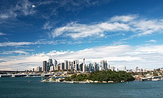
Goat Island is a heritage-listed island located in Port Jackson, in Sydney, New South Wales, Australia. Located northwest of the Sydney central business district, Goat Island is about 300m wide in a north/south direction and 180m long in an east/west direction; and covers an area of 5.4 hectares. Goat Island lies off the shores of the Sydney suburbs of Balmain and Millers Point, at the junction of Darling Harbour with the main channel of Sydney Harbour.

The North Head Quarantine Station is a heritage-listed former quarantine station and associated buildings that is now a tourist attraction at North Head Scenic Drive, on the north side of Sydney Harbour at North Head, near Manly, in the Northern Beaches Council local government area of New South Wales, Australia. It is also known as North Head Quarantine Station & Reserve and Quarantine Station & Reserve. The property is owned by the Office of Environment and Heritage, an agency of the Government of New South Wales. The buildings and site were added to the New South Wales State Heritage Register on 2 April 1999. The entire 277-hectare (680-acre) North Head site, including the Quarantine Station and associated buildings and facilities, was added to the Australian National Heritage List on 12 May 2006, and now forms part of the Sydney Harbour National Park.

Prospect Hill, or Marrong Reserve, is a heritage-listed hill in Pemulwuy and Prospect in the greater western region of Sydney, New South Wales, Australia. Situated about 30 kilometres west of central Sydney, the hill is Sydney's largest body of igneous rock and is higher than the ridges of the Cumberland Plain around it, with its present-day highest point being 117 metres high, although before its summit was quarried away it rose to a height of 131 metres above sea level.
The Mount Wood Station, also known as simply Mt Wood, is a heritage-listed former cattle station that now forms part of the Sturt National Park in Tibooburra in the Unincorporated Far West region of New South Wales, Australia. The cattle station was built between 1890 and 1969. As a national park, the property is owned by the NSW Officer of Environment and Heritage, an agency of the Government of New South Wales. It was added to the New South Wales State Heritage Register on 2 April 1999.

Kunderang East Pastoral Station is a heritage-listed former pastoral station at Jeogla, Armidale Regional Council, New South Wales, Australia. It was built from 1892 to 1893 by Joe Small. It is also known as Cunderang / Kunderang station or Apsley Gorges. The property is owned by the Office of Environment and Heritage. It was added to the New South Wales State Heritage Register on 2 April 1999.

Lidcombe Hospital Precinct is a heritage-listed former hospital and home for the aged, now converted to private housing, located at Joseph Street, Lidcombe, Cumberland Council, New South Wales, Australia. It was designed by James Barnet, Walter Liberty Vernon, Cobden Parkes and Ken Woolley and built from 1885 by the Government of New South Wales. It is also known as Rookwood Asylum for the Aged and Infirm; Rookwood State Hospital and Asylum for Men; Lidcombe State Hospital & Home; Rookwood Boys Reformatory & Model Farm. The property is now owned by Australand Industrial No. 18 Pty Limited and the Sydney Olympic Park Authority. It was added to the New South Wales State Heritage Register on 24 February 2006.

Oaklands is a heritage-listed homestead at Princes Highway, Pambula, Bega Valley Shire, New South Wales, Australia. It was built from 1842 by Messrs Robertson, Hall and Rogers. It was also known as Pamboola Station. It was added to the New South Wales State Heritage Register on 20 February 2004.

The Veteran Hall Remains are the heritage-listed archaeological remains of the former Veteran Hall house at Great Western Highway, Prospect, City of Blacktown, New South Wales, Australia. Veteran Hall was built in 1821 by William Lawson. The property is owned by Sydney Water. It was added to the New South Wales State Heritage Register on 18 November 1999.

The Bungarribee Homestead Site is a heritage-listed archaeological site at the location of the former Bungarribee Homestead. The site is located at Doonside Road, Doonside, New South Wales, a suburb of Sydney, Australia. It was added to the New South Wales State Heritage Register on 8 December 2000.

Savernake Station is a heritage-listed working farm located at 2341 Mulwala Road, Savernake, Federation Council, New South Wales, Australia. It was designed and built from 1862. It is also known as Savernake Homestead. It was added to the New South Wales State Heritage Register on 15 March 2013. The heritage listing includes the station's moveable heritage, including significant collections and archives relating to the property.
The Bundian Way is a 265-kilometre (165 mi) travelling route, notable for its significance in facilitating cultural exchamge, maritime trade, education, and exploration by Indigenous Australians. The heritage-listed route forms part of the modern-day Kosciuszko National Park, state forest, and local roads. It stretches from Mount Kosciuszko in the Snowy Mountains, through the Monaro region to Eden on the far South Coast of New South Wales. It was added to the New South Wales State Heritage Register on 18 January 2013, where it is also known as the Aboriginal track path.

The Cattai Estate is a heritage-listed former farm and cultural landscape and now national park at Wisemans Ferry Road, Cattai, New South Wales, an outer suburb of Sydney, Australia. It was built from 1804 to 1821. It is also known as Caddai Estate, Cattai National Park and Caddie estate. The property is owned by Office of Environment and Heritage, an agency of the Government of New South Wales. It was added to the New South Wales State Heritage Register on 2 April 1999.
Arnprior is a heritage-listed homestead and farm at Mayfield Road, Larbert, in the Southern Tablelands region of New South Wales, Australia. It was built from 1827 by William Ryrie. It was added to the New South Wales State Heritage Register on 18 November 1999.

Kirkham Stables is a heritage-listed former horse stud and dairy and now vacant building and beef cattle farm at Kirkham Lane in the south-western Sydney suburb of Narellan in the Camden Council local government area of New South Wales, Australia. It was built from 1816 by John Oxley. It is also known as Kirkham Stables and Precinct. The property is privately owned. It was added to the New South Wales State Heritage Register on 11 August 2000.

Denbigh is a heritage-listed former vineyard, Clydesdale horse stude, Ayrshire cattle stud and dairy farm and now Hereford stud located at 421 The Northern Road in the southern-western Sydney suburb of Cobbitty in the Camden Council local government area of New South Wales, Australia. It was built during 1818 by Charles Hook in c. 1818 and by Thomas and Samual Hassall, and Daniel Roberts in c. 1828. The property is privately owned. It was added to the New South Wales State Heritage Register on 22 December 2006.
Orielton is a heritage-listed former hunting, pleasure garden, farming estate, weekender, cereal cropping, flour mill and pastoral property and now horse agistment and residence located at 181 - 183 Northern Road in the south-western Sydney suburb of Harrington Park in the Camden Council local government area of New South Wales, Australia. It was designed and built from 1815 to 1834. It is also known as Orielton Farm and Orielton Homestead. The property is privately owned. It was added to the New South Wales State Heritage Register on 22 December 2006.

Oran Park is a heritage-listed former golf course, private residence and golf clubhouse and now private residence located at 112-130 Oran Park Drive in the south-western Sydney suburb of Oran Park in the Camden Council local government area of New South Wales, Australia. It was built from 1837 to 1946. It is sometimes referred to as Catherine Park House due to a land subdivision of Catherine Fields, however "Catherine Park" is only a developer's name for the area and not a true suburb. The property is privately owned. It was added to the New South Wales State Heritage Register on 5 March 2015.
Cox's Cottage is a heritage-listed pasturing land and residence located at 2 St Thomas Road in the western Sydney suburb of Mulgoa in the City of Penrith local government area of New South Wales, Australia. It was built from 1810 to 1811 by James King. It is also known as Mulgoa Cottage; The Cottage, Coxs Cottage, and was formally known as Fern Hill and Estate of Mulgoa before the new house was built. The property remains privately owned and is the oldest house in Australia still in residence. It was added to the New South Wales State Heritage Register on 2 April 1999.
Googong Foreshores is a heritage-listed historic precinct at London Bridge Road, Burra, New South Wales, Australia. It consists of the historic surroundings of the Googong Dam that predated the dam itself. It is also known as the Googong Foreshores Cultural and Geodiversity Heritage Areas. It was added to the Australian Commonwealth Heritage List on 3 November 2017.

Mamre is a heritage-listed former farm homestead complex, grain cropping, pastoral property and wool production and now residence, community facility, market gardening and nursery production located at Mamre Road in the western Sydney suburb of Orchard Hills in the City of Penrith local government area of New South Wales, Australia. It was built from 1822 to 1832. The property is owned by the New South Wales Department of Planning and Infrastructure. It was added to the New South Wales State Heritage Register on 2 April 1999.

