
In archaeology, excavation is the exposure, processing and recording of archaeological remains. An excavation site or "dig" is the area being studied. These locations range from one to several areas at a time during a project and can be conducted over a few weeks to several years.
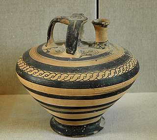
An artifact, or artefact, is a general term for an item made or given shape by humans, such as a tool or a work of art, especially an object of archaeological interest. In archaeology, the word has become a term of particular nuance and is defined as an object recovered by archaeological endeavor, which may be a cultural artifact having cultural interest.

In archaeological excavation, a feature is a collection of one or more contexts representing some human non-portable activity, such as a hearth or wall. Features serve as an indication that the area in which they are found has been interfered with in the past, usually by humans.

In archaeology a section is a view in part of the archaeological sequence showing it in the vertical plane, as a cross section, and thereby illustrating its profile and stratigraphy. This may make it easier to view and interpret as it developed over time.

Urban archaeology is a sub discipline of archaeology specializing in the material past of towns and cities where long-term human habitation has often left a rich record of the past. In modern times, when someone talks about living in a city, they are in an area with many surrounding people and buildings, generally quite tall ones. In archaeological terms, cities give great information because of the infrastructure they have and amounts of people that were around one another. Through the years there has been one big method used for Urban archaeology along with significant historic developments.

Danebury is an Iron Age hill fort in Hampshire, England, about 19 kilometres (12 mi) north-west of Winchester. The site, covering 5 hectares, was excavated by Barry Cunliffe in the 1970s. Danebury is considered a type-site for hill forts, and was important in developing the understanding of hill forts, as very few others have been so intensively excavated.

In archaeology a posthole or post-hole is a cut feature used to hold a surface timber or stone. They are usually much deeper than they are wide; however, truncation may not make this apparent. Although the remains of the timber may survive, most postholes are mainly recognisable as circular patches of darker earth when viewed in plan. Archaeologists can use their presence to plot the layout of former structures, as the holes may define its corners and sides. Construction using postholes is known as earthfast or post in ground construction.
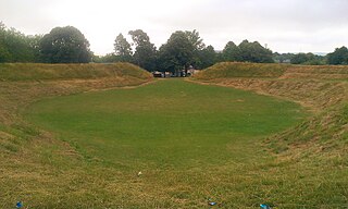
Maumbury Rings is a Neolithic henge in the south of Dorchester town in Dorset, England. It is a large circular earthwork, 85 metres in diameter, with a single bank and an entrance to the north east. It was modified during the Roman period when it was adapted for use as an amphitheatre, and the site was remodelled again during the English Civil War when it was used as an artillery fort guarding the southern approach to Dorchester. The monument is now a public open space, and used for open-air concerts, festivals and re-enactments.

Stratigraphy is a key concept to modern archaeological theory and practice. Modern excavation techniques are based on stratigraphic principles. The concept derives from the geological use of the idea that sedimentation takes place according to uniform principles. When archaeological finds are below the surface of the ground, the identification of the context of each find is vital in enabling the archaeologist to draw conclusions about the site and about the nature and date of its occupation. It is the archaeologist's role to attempt to discover what contexts exist and how they came to be created. Archaeological stratification or sequence is the dynamic superimposition of single units of stratigraphy, or contexts.

The Harris matrix is a tool used to depict the temporal succession of archaeological contexts and thus the sequence of depositions and surfaces on a 'dry land' archaeological site, otherwise called a 'stratigraphic sequence'. The matrix reflects the relative position and stratigraphic contacts of observable stratigraphic units, or contexts. The Matrix was developed in 1973 in Winchester, England, by Dr. Edward C. Harris.

In archaeological excavation, a plan is a drawn record of features and artifacts in the horizontal plane.

In archaeology, a phase refers to the logical reduction of contexts recorded during excavation to nearly contemporary archaeological horizons that represent a distinct "phase" of previous land use. These often but not always will be a representation of a former land surface or occupation level and all associated features that were created into or from this point in time. A simplified description of phase would be that "a phase is a view of a given archaeological site as it would have been at time X".

An archaeological relationship is the position in space and by implication, in time, of an object or context with respect to another. This is determined, not by linear measurement but by determining the sequence of their deposition – which arrived before the other. The key to this is stratigraphy.

Single context recording was initially developed by Ed Harris and Patrick Ottaway in 1976, from a suggestion by Laurence Keene. It was further developed by the Department of Urban Archaeology from where it was then exported, in the mid-1980s by Pete Clarke to the Scottish Urban Archaeological Trust and Nick Pearson to the York Archaeological Trust. It has become a popular system of recording and planning being used in many countries in Europe and in Lebanon, it is especially suited to the complexities of deep, typically urban, archaeology. Each excavated context is given a unique "context number" and is recorded by type on a context sheet and perhaps being drawn on a plan and/or a section. Depending on time constraints and importance contexts may also be photographed, but in this case a grouping of contexts and their associations are the purpose of the photography. Finds from each context are bagged and labelled with their context number and site code for later cross-reference work carried out post excavation. The height above sea level of pertinent points on a context, such as the top and bottom of a wall are taken and added to plans sections and context sheets. Heights are recorded with a dumpy level or total station by relation to the site temporary benchmark. Samples of deposits from contexts are sometimes also taken, for later environmental analysis or for scientific dating.
In archaeology a fill is the material that has accumulated or has been deposited into a cut feature such as ditch or pit of some kind of a later date than the feature itself. Fills are an important part of the archaeological record as their formation and composition can throw light on many aspects of archaeological study.
Archaeological illustration is a form of technical illustration that records material derived from an archaeological context graphically.

The Trundle is an Iron Age hillfort on St Roche's Hill about 4 miles (6 km) north of Chichester, West Sussex, England, built on the site of a causewayed enclosure, a form of early Neolithic earthwork found in northwestern Europe. Causewayed enclosures were built in England from shortly before 3700 BC until about 3300 BC; they are characterized by the full or partial enclosure of an area with ditches that are interrupted by gaps, or causeways. Their purpose is not known; they may have been settlements, meeting places, or ritual sites. Hillforts were built as early as 1000 BC, in the Late Bronze Age, and continued to be built through the Iron Age until shortly before the Roman occupation. A chapel dedicated to St Roche was built on the hill around the end of the 14th century; it was in ruins by 1570. A windmill and a beacon were subsequently built on the hill. The site was occasionally used as a meeting place in the post-medieval period.
Archaeology or archeology is the study of human activity through the recovery and analysis of material culture. The archaeological record consists of artifacts, architecture, biofacts or ecofacts, sites, and cultural landscapes. Archaeology can be considered both a social science and a branch of the humanities. In Europe it is often viewed as either a discipline in its own right or a sub-field of other disciplines, while in North America archaeology is a sub-field of anthropology.

In civil engineering, a cut or cutting is where soil or rock from a relative rise along a route is removed. The term is also used in river management to speed a waterway's flow by short-cutting a meander.
This page is a glossary of archaeology, the study of the human past from material remains.


