Archaeoastronomy is the interdisciplinary or multidisciplinary study of how people in the past "have understood the phenomena in the sky, how they used these phenomena and what role the sky played in their cultures". Clive Ruggles argues it is misleading to consider archaeoastronomy to be the study of ancient astronomy, as modern astronomy is a scientific discipline, while archaeoastronomy considers symbolically rich cultural interpretations of phenomena in the sky by other cultures. It is often twinned with ethnoastronomy, the anthropological study of skywatching in contemporary societies. Archaeoastronomy is also closely associated with historical astronomy, the use of historical records of heavenly events to answer astronomical problems and the history of astronomy, which uses written records to evaluate past astronomical practice.
Ley lines are straight alignments drawn between various historic structures, prehistoric sites and prominent landmarks. The idea was developed in early 20th-century Europe, with ley line believers arguing that these alignments were recognised by ancient societies that deliberately erected structures along them. Since the 1960s, members of the Earth Mysteries movement and other esoteric traditions have commonly believed that such ley lines demarcate "earth energies" and serve as guides for alien spacecraft. Archaeologists and scientists regard ley lines as an example of pseudoarchaeology and pseudoscience.

The study of alignments of random points in a plane seeks to discover subsets of points that occupy an approximately straight line within a larger set of points that are randomly placed in a planar region. Studies have shown that such near-alignments occur by chance with greater frequency than one might intuitively expect.

Alexander Thom was a Scottish engineer most famous for his theory of the Megalithic yard, categorisation of stone circles and his studies of Stonehenge and other archaeological sites.

The Dorset Cursus is a Neolithic cursus monument that spans across 10 km of the chalk downland of Cranborne Chase in east Dorset, United Kingdom. Its extreme length makes it a notable example of this class of linear earthwork; it is better interpreted as a pair of same-length cursus constructed end to end, with the more southerly cursus pre-dating the northerly one.

Historically, most medicine wheels follow a similar pattern of a central circle or cluster of stones, surrounded by an outer ring of stones, along with "spokes" radiating from the center out to the surrounding ring. Often, but not always, the spokes may be aligned to the cardinal directions. In other cases, some stones may be aligned with astronomical phenomena. These stone structures may be called "medicine wheels" by the Indigenous nation which built them, or by more specific names in that nation's language.

A stone row or stone alignment is a linear arrangement of megalithic standing stones set at intervals along a common axis or series of axes, usually dating from the later Neolithic or Bronze Age. Rows may be individual or grouped, and three or more aligned stones can constitute a row.
Earth mysteries are a wide range of spiritual, religious ideas focusing on cultural and religious beliefs about the Earth, generally with a regard for specific geographic locations of historic importance. Similar to modern druidry, prehistoric monuments are of particular spiritual importance to believers in Earth mysteries who consider certain locations to be sacred and/or containing active spiritual energies. The term "alternative archaeology" has also been used to describe the study of Earth mystery beliefs.

Petroforms, also known as boulder outlines or boulder mosaics, are human-made shapes and patterns made by lining up large rocks on the open ground, often on quite level areas. Petroforms in North America were originally made by various Native American and First Nation tribes, who used various terms to describe them. Petroforms can also include a rock cairn or inukshuk, an upright monolith slab, a medicine wheel, a fire pit, a desert kite, sculpted boulders, or simply rocks lined up or stacked for various reasons. Old World petroforms include the Carnac stones and many other megalithic monuments.

Nabta Playa was once a large endorheic basin in the Nubian Desert, located approximately 800 kilometers south of modern-day Cairo or about 100 kilometers west of Abu Simbel in southern Egypt, 22.51° north, 30.73° east. Today the region is characterized by numerous archaeological sites. The Nabta Playa archaeological site, one of the earliest of the Egyptian Neolithic Period, is dated to circa 7500 BC.
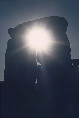
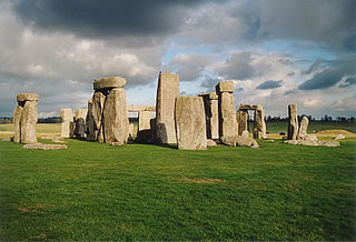
The prehistoric monument of Stonehenge has long been studied for its possible connections with ancient astronomy. The site is aligned in the direction of the sunrise of the summer solstice and the sunset of the winter solstice.
The Medicine Wheel/Medicine Mountain National Historic Landmark is a medicine wheel located in the Bighorn National Forest, in the U.S. state of Wyoming. The Medicine Wheel at Medicine Mountain is a large stone structure made of local white limestone laid upon a bedrock of limestone. It is both a place of sacred ceremony and scientific inquiry. In Native Science these uses are not distinguished as separate as they are in Western science.

Carahunge, also known as Zorats Karer, Dik-Dik Karer, Tsits Karer and Karenish (Քարենիշ), is a prehistoric archaeological site near the town of Sisian in the Syunik Province of Armenia. It is also often referred to among international tourists as the "Armenian Stonehenge".

The U.S. National Register of Historic Places (NRHP) classifies its listings by various types of properties. Listed properties generally fall into one of five categories, though there are special considerations for other types of properties which do not fit into these five broad categories or fit into more specialized subcategories. The five general categories for NRHP properties are: building, district, object, site, and structure.
Paul Devereux is a British author, researcher, lecturer, broadcaster, artist and photographer based in the UK. Devereux is a co-founder and the managing editor of the academic publication Time & Mind – the Journal of Archaeology, Consciousness and Culture, a research associate with the Royal College of Art (2007–2013), and a Research Fellow with the International Consciousness Research Laboratories (ICRL) group at Princeton University.
An astronomical complex or commemorative astronomical complex is a series of man-made structures with an astronomical purpose. It has been used when referring to a group of Megalithic structures that it is claimed show high precision astronomical alignments. For the study of Archaeoastronomy, such complexes of similar structures are required for adequate measurement and calculation to ensure that similar celestial sightlines were intended by the designers. These arrangements have also been known as observational, ceremonial or ritual complexes with importance for the study of prehistoric cultures.
Maya astronomy is the study of the Moon, planets, Milky Way, Sun, and astronomical phenomena by the Precolumbian Maya Civilization of Mesoamerica. The Classic Maya in particular developed some of the most accurate pre-telescope astronomy in the world, aided by their fully developed writing system and their positional numeral system, both of which are fully indigenous to Mesoamerica. The Classic Maya understood many astronomical phenomena: for example, their estimate of the length of the synodic month was more accurate than Ptolemy's, and their calculation of the length of the tropical solar year was more accurate than that of the Spanish when the latter first arrived. Many temples from the Maya architecture have features oriented to celestial events.

The Ancestral Puebloans, also known as the Anasazi and by the earlier term the Basketmaker-Pueblo culture, were an ancient Native American culture that spanned the present-day Four Corners region of the United States, comprising southeastern Utah, northeastern Arizona, northwestern New Mexico, and southwestern Colorado. They are believed to have developed, at least in part, from the Oshara tradition, which developed from the Picosa culture. The people and their archaeological culture are often referred to as Anasazi, a term introduced by Alfred V. Kidder from the Navajo word anaasází meaning 'enemy ancestors' although Kidder thought it meant 'old people'. Contemporary Puebloans object to the use of this term, with some viewing it as derogatory.

An axial stone circle is a megalithic ring of stones of a particular design found in County Cork and County Kerry in southwest Ireland. Archaeologists have found it convenient to consider the axial five-stone circle and axial multiple-stone circle separately. The circle has an approximate axis of symmetry aligned in a generally northeast–southwest direction. The stone at the southwest side of the circle, rather than being an upright orthostat like all the rest, is a slab lying horizontally with its long thin edge along the circumference of the ring. Because it marks the axis of the circle it is called the axial stone.

