The Mississippi River is the primary river of the largest drainage basin in the United States. From its traditional source of Lake Itasca in northern Minnesota, it flows generally south for 2,340 miles (3,766 km) to the Mississippi River Delta in the Gulf of Mexico. With its many tributaries, the Mississippi's watershed drains all or parts of 32 U.S. states and two Canadian provinces between the Rocky and Appalachian mountains. The river either borders or passes through the states of Minnesota, Wisconsin, Iowa, Illinois, Missouri, Kentucky, Tennessee, Arkansas, Mississippi, and Louisiana. The main stem is entirely within the United States; the total drainage basin is 1,151,000 sq mi (2,980,000 km2), of which only about one percent is in Canada. The Mississippi ranks as the world's tenth-largest river by discharge flow, and the largest in North America.

The striated heron also known as mangrove heron, little green heron or green-backed heron, is a small heron, about 44 cm tall. Striated herons are mostly sedentary and noted for some interesting behavioural traits. Their breeding habitat is small wetlands in the Old World tropics from west Africa to Japan and Australia, and in South America and the Caribbean. Vagrants have been recorded on Oceanic islands, such as Chuuk and Yap in the Federated States of Micronesia, the Marianas and Palau; the bird recorded on Yap on February 25, 1991, was from a continental Asian rather than from a Melanesian population, while the origin of the bird seen on Palau on May 3, 2005 was not clear.

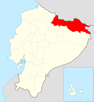
Sucumbíos is a province in northeast Ecuador. The capital and largest city is Nueva Loja. It is the fifth largest province in the country, with an area of 18,084 km2. In 2010, it had a population of 176,472 inhabitants.

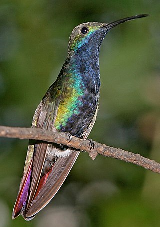
The black-throated mango is a species in subfamily Polytminae of the hummingbird family Trochilidae. It is found in Panama, in every mainland South American country except Chile, and in Trinidad and Tobago.

The white-winged swallow is a resident breeding swallow in tropical South America from Colombia, Venezuela, Trinidad, and Argentina. It is not found west of the Andes. This swallow is largely non-migratory.

The red-capped cardinal is a small species of bird in the tanager family Thraupidae. It is found in South America.
Ramón Piaguaje, is the son of Cecilio Piaguaje, the Chief of the Secoya Indians. He lives with his wife and four children deep in the rainforest in Secoya territory, close to the Aguarico River. From an early age, he drew the rainforest with his fingers in the sand and later worked with black ink on paper. The young man who has captured the attention of the art world was first encouraged in his efforts by Orville and Mary Johnson, Wycliffe Bible Translators working in his village. The discovery of colored pencils at the evangelical missionary school he later attended enabled him to further develop his talent.
The Siona people are an indigenous ethnic group living in the Ecuadorian Amazon or Oriente, and in Putumayo Department in Colombia. They share territory along the Shushufindi, Aguarico, and Cuyabeno river with the Secoya people, with whom they are sometimes considered a single population.
The Secoya are an indigenous peoples living in the Ecuadorian and Peruvian Amazon. They speak the Secoya language Pai Coca, which is part of the Western Tucanoan language group. In Ecuador the Secoya number about 400 people who for the most part are located in three settlements, Eno, San Pablo de Katitsiaya and Siecoya Remolino, all found on the banks of the Aguarico river. Their Ecuadorian territory covers 40.000 hectares along the Shushufindi, Aguarico, and Cuyabeno river in the state of Sucumbios. Until recently they shared territory with the Siona people, with whom they are sometimes considered a single population, although both peoples have independent governance. In Peru the Secoya population numbers about 700.
The Teteté were a small group of Western Tucanoan speakers, who once lived in the Ecuadorian Amazon or Oriente. Today, their territory would lie within Ecuador’s Cuyabeno Wildlife Reserve, a popular site for ecotourism. From 1877 through the 1920s, however, Ecuadorian and Colombian rubber collectors (caucheros) and their native press gangs worked this part of the upper Aguarico and Putumayo watersheds, shooting or kidnapping Tetete people whenever they showed themselves. Sometime before 1940, most of the remaining Tetete were killed in a raid by neighboring Siona people. “On a sandbar, the two groups faced each other in long lines and began to fight. Very soon, the Siona won; a few Tetete escaped, others died, and several were wounded…Later, a Siona man found them fishing on Lake Cuyabeno, and they wounded him slightly in the shoulder…After that, we never saw them again.”. Large numbers of the Teteté were ultimately driven to extinction by missionaries and petroleum companies after oil exploration began nearby in 1964. The Ecuadorian Government officials have stated that the extinction of the Tetete people was partly caused by the encroachment of Texaco onto their land. The loss of hunting grounds to deforestation caused by oil expansion and subsequent oil contamination contributed to their extinction.
Güeppi-Sekime National Park is a protected area located in the Peruvian region of Loreto, on the border with Ecuador. The park encompasses 203,628.51 hectares (2,036 km2) of forests in a landscape that features hills and seasonally flooded lowlands.
Hyloxalus sauli is a species of frogs in the family Dendrobatidae. It is found on the eastern Andean slopes in Putumayo, Colombia, and in Sucumbíos, Napo, Orellana, and Pastaza Provinces, Ecuador. It is named after William Saul from the University of Kansas Natural History Museum.
Maku or Maco is a pejorative term referring to several hunter-gatherer peoples of the upper Amazon, derived from an Arawakan term ma-aku "do not speak / without speech". Nimuendajú (1950), for example, notes six peoples of Colombia, Venezuela, and Brazil that are known as 'Maku'. In linguistic literature, the term refers primarily to:

The Cuyabeno Wildlife Reserve is the second largest reserve of the 56 national parks and protected areas in Ecuador. It is located in the Putumayo Canton in the Sucumbíos Province and in the Aguarico Canton in the Orellana Province. It was decreed on 26 July 1979 as part of the creation of the national protected areas system based on the recommendations of the FAO report on the "National Strategy on the Conservation of Outstanding Wild Areas of Ecuador".

Tarapoa is a location in the province of Sucumbíos in Ecuador and the seat of the canton of Cuyabeno.

Aguarico Canton is a canton of Ecuador, located in the Orellana Province. Its capital is the town of Nuevo Rocafuerte. Its population at the 2010 census was 4,658 INEC 2010.

Cuyabeno Canton is a canton of Ecuador, located in the Sucumbíos Province. Its capital is the town of Tarapoa. Its population at the 2001 census was 6,643.

Ecuador is a nation in northwest South America known as the Republic of Ecuador. Hundreds of thousands of kinds of plants and animals can be found there as a result of the diversity of its four zones. There are roughly 1640 bird species there. Along with the 4,500 kinds of butterflies, there are also 345 reptiles, 358 amphibians, and 258 mammals. Ecuador is regarded as one of the 17 nations with the highest concentration of biodiversity on Earth. The majority of its animals and plants are found in 26 state-protected areas. It also provides gastronomy, a range of cultures and customs, and historical attractions like Quito.
Trachycephalus macrotis, also known as the Amazonian milk frog and known in Spanish as rana lechera de Pastaza, is a frog in the family Hylidae. It is endemic to Peru and Ecuador. Scientists have seen it between 225 and 925 m above sea level.


