Llandeilo is a town and community in Carmarthenshire, Wales, situated at the crossing of the River Towy by the A483 on a 19th-century stone bridge. Its population was 1,795 at the 2011 Census. It is adjacent to the westernmost point of the Brecon Beacons National Park. The town is served by Llandeilo railway station on the Heart of Wales Line.

The Diocese of Llandaff is an Anglican diocese that traces its roots to pre-Reformation times as heir of a Catholic bishopric. It is headed by the Bishop of Llandaff, whose seat is located at the Cathedral Church of Saint Peter and Saint Paul in Llandaff, a suburb of Cardiff. It currently covers most of the former Welsh county of Glamorgan, but once stretched from the River Towy to the middle of the Wye Valley.

The Diocese of St Davids is a diocese of the Church in Wales, a church of the Anglican Communion. The diocese covers the historic extent of Ceredigion, Carmarthenshire and Pembrokeshire, together with a small part of western Glamorgan. The episcopal see is the Cathedral Church of St David in the City of St Davids, Pembrokeshire. The present cathedral, which was begun in 1181, stands on the site of a monastery founded in the 6th century by Saint David.

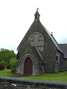
Bethlehem is a tiny farming village in the county of Carmarthenshire, Wales, lying in the Tywi Valley northeast of Llandeilo and southwest of Llangadog but on the opposite side of the river from the busy London to Haverfordwest road, the A40.
Llangolman is a village and parish in the southeastern Preseli Hills in Pembrokeshire, Wales. It is part of the community of Mynachlog-ddu. There are prehistoric remains nearby and the parish has a history of slate and clay quarrying.

Llansadwrn is a small village and community in Carmarthenshire, Wales.
Cilymaenllwyd is a community on the extreme northwest of Carmarthenshire in Wales. The community population at the 2011 census was 742. It lies about 25 miles (40 km) west of Carmarthen, 12 miles (19 km) southeast of Fishguard and 15 miles (24 km) northeast of Haverfordwest. The A478 road runs through the community.

Llangadog is a village and community in Carmarthenshire, Wales, which also includes the villages of Bethlehem and Capel Gwynfe. A notable local landscape feature is Y Garn Goch with two Iron Age hill forts.

Llangynog is a village and community located in Carmarthenshire, Wales, the main settlement of which was once called ‘Ebenezer’village. It is bordered by the communities of: Newchurch and Merthyr; Carmarthen; Llangain; Llansteffan; Laugharne Township; and St Clears, all being in Carmarthenshire. The population at the 2011 census was 492.

The River Gavenny or sometimes the Gavenny River is a short river in Monmouthshire in south Wales. It rises 1 mile (1.6 km) southwest of the village of Llanvihangel Crucorney from springs near Penyclawdd Court, supplemented by springs in Blaen-Gavenny Wood and tributary streams there and within the Woodland Trust-owned Great Triley Wood. It flows south for about 4 miles (6.4 km) to its confluence with the River Usk towards the eastern end of Castle Meadows at Abergavenny. The town derives its English-language name from the Gavenny's confluence with the River Usk. Of the buildings on the banks of the river, the Gothic Decorated style church of St Teilo at Llantilio Pertholey is especially notable. Parts of the church date from the thirteenth century with multiple additions since. Blaengavenny Farm, the name of which signifies the 'head of the Gavenny', is a sixteenth-century farmhouse near the river's source.

Y Garn Goch is a hill in the Brecon Beacons National Park in the east of Carmarthenshire, Wales. The name means the 'red cairn'. It lies near the village of Bethlehem, three miles southwest of Llangadog and four miles east of Llandeilo on the southern side of the broad Towy Valley. It is also commonly known as either Garn Goch or Carn Goch. Current owners and land managers are the Brecon Beacons National Park Authority.
Trap is a hamlet in the county of Carmarthenshire in southwest Wales, located on the western border of the Brecon Beacons National Park, around four miles southeast of the town of Llandeilo. It is unclear whether the name – which often appears as Trapp on maps, although the spelling with a single p is generally preferred locally – refers to a fish-trap, a water-trap (mill-leat), or, given that the village is in Cwm Lladron, an ambush point.
Llandeilo Llwydarth or Llandilo is an ancient area and parish in the Preseli Hills between Llangolman and Maenclochog in the community of Maenclochog, Pembrokeshire, Wales.
Cwmerfyn is a hamlet in the community of Trefeurig, Ceredigion, Wales, nine miles (14 km) by road east of Aberystwyth. Historically Cwmerfyn was a lead ore mining village.

Scleddau is a village and a community in the county of Pembrokeshire, Wales, and is 2 miles (3.2 km) south of Fishguard on the main A40 road. The Western Cleddau river which lends its name to the village flows under the main road. There are several springs in the village.

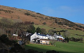
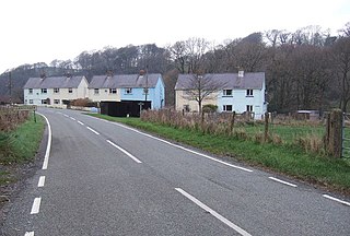
Gwynfe or Capel Gwynfe is a small village inside the portion of Brecon Beacons National Park that is in Carmarthenshire, a county of southwestern Wales. This village is situated between Trichrug and the western slopes of the Black Mountain, to the west of the A4069 road about halfway between Llangadog and Brynamman. The village comprises a scattered collection of mostly nineteenth and twentieth-century housing that developed around several chapels. The area around the village is mainly farmland and the village was 2004 'Village of the Year for Carmarthenshire'. The village has a grade-two listed phone box now used as an information centre and a modern community hall built in 2001. The community association have erected 2 large woodcarvings of three red kites.

Thomas Thomas was a Welsh church minister and chapel architect, also known as Thomas Glandŵr. He is described as "the first national architect of Wales" and the "unchallenged master of chapel architecture in Wales in the 1860s".
Llanychaer is a small rural village and parish in the community of Cwm Gwaun, north Pembrokeshire, Wales. It is 2 miles (3.2 km) southeast of the port of Fishguard.