
Pasco County is a county located on the west central coast of the U.S. state of Florida. According to the 2010 census, the population was 464,697. Its county seat is Dade City, and its largest city is New Port Richey. The county is named after Samuel Pasco.

Dade County is a county located in the southwest part of the U.S. state of Missouri. As of the 2010 census, the population was 7,883. Its county seat is Greenfield. The county was organized in 1841 and named after Major Francis L. Dade of Virginia, who was killed in the Second Seminole War in 1835.

Dade County is a county in the U.S. state of Georgia. It occupies the northwest corner of Georgia, and the county's own northwest corner is the westernmost point in the state. As of the 2010 census, the population is 16,633. The county seat and only incorporated municipality is Trenton. Dade County is part of the Chattanooga, TN–GA Metropolitan Statistical Area. In 1860, residents of Dade County voted to secede from the state of Georgia and from the United States, but no government outside the county ever recognized this gesture as legal. In 1945, the county symbolically "rejoined" Georgia and the United States.
Dade City is a city in and the county seat of Pasco County, Florida, United States. It is located in the Tampa Bay Area. The population was 6,437 at the 2010 census.
Trenton is a city in Dade County, Georgia, United States. The population was 2,301 at the 2010 census. It is the only incorporated municipality in the county, and as such it serves as the county seat. Trenton is part of the Chattanooga, Tennessee–GA Metropolitan Statistical Area.

The Gold Coast is a region of the U.S. state of Florida. It is located on the Atlantic coast of South Florida, including the cities of Miami, Ft. Lauderdale and West Palm Beach though its definition has changed over time. One of the best known of Florida's vernacular regions, the name is a reference to the wealth and ritzy tropical lifestyle that characterizes the area.
State Road 997, also known as Krome Avenue and West 177th Avenue is a 36.7-mile-long (59.1 km) north–south state highway in western Miami-Dade County, Florida. It runs from State Road 998 in Homestead north across U.S. Route 41 to U.S. Route 27 near Countyline Dragway, just south of the Broward County line. Its main use is as a bypass around the western side of Miami, linking the routes that run southwest, west and northwest from that city. The road passes through newer suburbs in the southern third of its length, while the northern two thirds of the highway traverse the eastern edge of the Everglades.
State Road 933, locally known as West 12th Avenue, and Ronald W. Reagan Avenue, is a 4.25-mile (6.84 km) long north–south street entirely within the city limits of Miami, Florida. Its southern terminus is an intersection with Coral Way as Coral Way changes from Southwest 22nd Street to Southwest Third Avenue; its northern terminus is an interchange with the Airport Expressway. North of Dolphin Expressway, reassurance signage is virtually nonexistent, and the only indication of SR 933 existing north of Northwest 14th Street is a pair of trailblazer signs on Northwest 36th Street.
County Road 854, locally known as Ives Dairy Road, Dan Marino Boulevard, and Honey Hill Drive, is the unsigned designation for an east–west commuter road spanning 8.7 miles (14.0 km) across northern Miami-Dade County, which encompasses sections of North 199th Street, North 202nd Street, North 203rd Street, and North 205th Terrace. Its western terminus is an intersection with Red Road/Northwest 57th Avenue near Miami Lakes and Carol City, the eastern terminus is an intersection with Biscayne Boulevard in Aventura, a half block east of an overpass over West Dixie Highway that once served as part of the Dixie Highway and US 1.
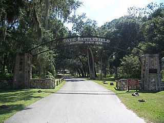
Dade Battlefield Historic State Park is a state park located on County Road 603 between Interstate 75 and U.S. Route 301 in Sumter County, Florida. The 80-acre (32 ha) park includes 40 acres (160,000 m2) of pine flatwoods and a live oak hammock. Also called the Dade Massacre site, it preserves the Second Seminole War battlefield where tribal Seminole warriors fought soldiers under the command of Major Francis L. Dade on December 28, 1835. Each year, on the weekend after Christmas, the Dade Battlefield Society sponsors a reenactment of the battle that started the Second Seminole War.

Egmont Key State Park is a Florida State Park located on Egmont Key, at the mouth of Tampa Bay, in the state of Florida, United States. It lies southwest of Fort De Soto Park and can only be reached by boat or ferry. The Egmont Key Lighthouse and the ruins of Fort Dade, a Spanish–American War era fort, are located in the park. Egmont Key is in Hillsborough County in a narrow strip of the county that extends along the Tampa Port Shipping Channel.

Crandon Park is a 808-acre (3.27 km2) urban park in metropolitan Miami, occupying the northern part of Key Biscayne. It is connected to mainland Miami via the Rickenbacker Causeway.
Galloway Road, also known as West 87th Avenue, is a north–south route through the western areas of suburban Miami-Dade County, Florida, from the Black Point area south of Cutler Bay almost to the Broward County line north of Miami Lakes. It exists in seven different unconnected segments that total 27.5 miles (44.3 km) in length, acting as connecting roads, neighborhood streets, and arterial routes. Approximately 9.5 miles (15.3 km) of Galloway Road, between Pinecrest and Doral, is designated as State Road 973.

The Government of Miami-Dade County is defined and authorized under the Constitution of Florida, Florida law, and the Home Rule Charter of Miami-Dade County.

Miami-Dade County is located in the southeastern part of the U.S. state of Florida. According to a 2019 census report, the county had a population of 2,716,940, making it the most populous county in Florida and the seventh-most populous county in the United States. It is also Florida's third largest county in terms of land area, with 1,946 square miles (5,040 km2). The county seat is Miami, the principal city in South Florida.

Miami-Dade County Public Schools (M-DCPS) is a public school district serving Miami-Dade County, in the U.S. state of Florida. Founded in 1885, it is the largest school district in Florida and the Southeastern United States, and, as of 2020, the fifth largest in the United States, with a student enrollment of 356,086 as of August 30, 2017.
North Township is a township in Dade County, in the U.S. state of Missouri.
South Township is a township in Dade County, in the U.S. state of Missouri.

The 2020 Miami-Dade County mayoral election will determine who will serve as the Mayor of Miami-Dade County, Florida beginning on November 17, 2020. Incumbent Mayor Carlos A. Giménez, first elected in 2011, is term-limited and cannot seek reelection to a third consecutive term.