
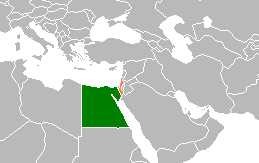
The Gaza Strip, also known simply as Gaza, is a small territory located on the eastern coast of the Mediterranean Sea; it is the smaller of the two Palestinian territories, the other being the West Bank, that make up the State of Palestine. Inhabited by mostly Palestinian refugees and their descendants, Gaza is one of the most densely populated territories in the world. Gaza is bordered by Egypt on the southwest and Israel on the east and north. The territory has been under Israeli occupation since 1967.

The Gaza–Israel barrier is a border barrier located on the Israeli side of the Gaza–Israel border. Before the Israel–Hamas war, the Erez Crossing, in the north of the Gaza Strip, used to be the only crossing point for people and goods coming from Israel into the Gaza Strip. A second crossing point, the Kerem Shalom border crossing, is used exclusively for goods coming from Egypt as Israel did not allow goods to go directly from Egypt into Gaza through the Egypt–Gaza border, except for the Salah Al Din Gate, which opened in 2018.
Rafah is a city in the southern Gaza Strip, Palestine. It is the capital of the Rafah Governorate of the State of Palestine, located 30 kilometers (19 mi) south-west of Gaza City. In 2017, Rafah had a population of 171,889. As a result of massive bombardment and ground assaults in Gaza City and Khan Yunis by Israel during the Israel–Hamas war, about 1.4 million Palestinians are believed to be sheltering in Rafah as of February 2024.

In 2005, 21 Israeli settlements in the Gaza Strip and four Israeli settlements in the West Bank were unilaterally dismantled. Israeli settlers and army evacuated from inside the Gaza Strip, redeploying its military along the border. The disengagement was conducted unilaterally by Israel; in particular, Israel rejected any coordination or orderly hand-over to the Palestinian Authority. Despite the disengagement, the Gaza Strip is still considered to be occupied under international law.

The Gaza Strip smuggling tunnels are smuggling tunnels that had been dug under the Philadelphi Route along the Egypt–Gaza border. They were dug to subvert the blockade of the Gaza Strip to smuggle in fuel, food, weapons and other goods into the Gaza Strip. After the Egypt–Israel peace treaty of 1979, the town of Rafah, in the southern Gaza Strip, was split by this buffer zone. One part is located in the southern part of Gaza, and the smaller part of the town is in Egypt. After Israel withdrew from Gaza in 2005, the Philadelphi Corridor was placed under the control of the Palestine Authority until 2007, when Hamas seized power in 2007, and Egypt and Israel closed borders with the Gaza Strip.

The Philadelphi Corridor, also called Philadelphi Route, is the Israeli code name for a narrow strip of land, some 100 metres wide and 14 km long, situated along the entirety of the border between the Gaza Strip and Egypt.

Gush Katif was a bloc of 17 Israeli settlements in the southern Gaza Strip. In August 2005, the Israel Defense Forces removed the 8,600 Israeli residents from their homes after a decision from the Cabinet of Israel. The communities were demolished as part of Israel's unilateral disengagement from Gaza.

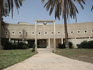
Neve Dekalim was an Israeli settlement in the Gaza Strip. Comprising a part of Gush Katif, it was founded in 1983, shortly after Israel withdrew from the Sinai Peninsula to fulfill the Egypt–Israel peace treaty. It served as a regional centre for the Gush Katif settlement bloc and was the seat of the defunct Hof Aza Regional Council. The settlement was located in between the Mediterranean Sea and the Khan Yunis refugee camp. In August 2005, Neve Dekalim was dismantled by the Israeli government in pursuit of the Disengagement Plan Implementation Law, which had been approved by the Knesset six months earlier.

This article describes transport in the State of Palestine, which consists of two non-contiguous territories, the West Bank and the Gaza Strip, different parts of which are administered by Palestinian National Authority, Hamas Administration in Gaza and Israel.
The European Union Border Assistance Mission at the Rafah Crossing Point is the EU's second Civilian Crisis Management Mission in the Palestinian territories, the other being the European Union Police Mission.
Kerem Shalom is a kibbutz in southern Israel. Located on the triple Gaza Strip-Israel-Egypt border, it falls under the jurisdiction of Eshkol Regional Council. In 2022 it had a population of 220.
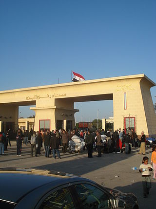
The Rafah Border Crossing or Rafah Crossing Point is the sole crossing point between Egypt and Palestine's Gaza Strip. It is located on the Egypt–Palestine border. Under a 2007 agreement between Egypt and Israel, Egypt controls the crossing but imports through the Rafah crossing require Israeli approval.

The Erez Crossing, also known as the Beit Hanoun Crossing, is a border crossing between the Gaza Strip and Israel. It is located at the northern end of the Gaza Strip, between the Israeli kibbutz of Erez and the Palestinian town of Beit Hanoun.

Sufa is a kibbutz in southern Israel. Located in the Hevel Shalom area of the north-western Negev desert, it falls under the jurisdiction of Eshkol Regional Council. In 2022 it had a population of 233.
Egypt–Israel relations are foreign relations between Egypt and Israel. The state of war between both countries which dated back to the 1948 Arab–Israeli War culminated in the Yom Kippur War in 1973, and was followed by the 1979 Egypt–Israel peace treaty a year after the Camp David Accords, mediated by U.S. president Jimmy Carter. Full diplomatic relations were established on January 26, 1980, and the formal exchange of ambassadors took place one month later, on February 26, 1980, with Eliyahu Ben-Elissar serving as the first Israeli Ambassador to Egypt, and Saad Mortada as the first Egyptian Ambassador to Israel. Egypt has an embassy in Tel Aviv and a consulate in Eilat. Israel has an embassy in Cairo and a consulate in Alexandria. Their shared border has two official crossings, one at Taba and one at Nitzana. The crossing at Nitzana is for commercial and tourist traffic only. The two countries' borders also meet at the shoreline of the Gulf of Aqaba in the Red Sea.

Kerem Shalom border crossing is a border crossing at the junction of two border sections: one between the Gaza Strip and Israel, and one between the Gaza Strip and Egypt. It is used by trucks carrying goods from Israel or Egypt to the Gaza Strip.
The August 2012 Sinai attack occurred on 5 August 2012, when armed men ambushed an Egyptian military base in the Sinai Peninsula, killing 16 soldiers and stealing two armored cars, which they used to infiltrate into Israel. The attackers broke through the Kerem Shalom border crossing to Israel, where one of the vehicles exploded. They then engaged in a firefight with soldiers of the Israel Defense Forces (IDF), during which six of the attackers were killed. No Israelis were injured.
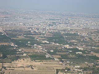
The Egypt–Palestine border, also called Egypt–Gaza border, is the 12-kilometre (7.5-mile) long border between Egypt and the Gaza Strip. There is a buffer zone along the border which is about 14 kilometres long.
The Agreement on Movement and Access (AMA) was an agreement between Israel and the Palestinian Authority (PA) signed on 15 November 2005 aimed at improving Palestinian freedom of movement and economic activity within the Palestinian territories, and open the Rafah Crossing on the Gaza–Egypt border. AMA was described as: ″an agreement on facilitating the movement of people and goods within the Palestinian Territories and on opening an international crossing on the Gaza-Egypt border that will put the Palestinians in control of the entry and exit of people.″ Part of the agreement was the Agreed Principles for Rafah Crossing.

