Dalur

Last updated
Dalur
Village
Dalur, Faroe Islands.JPG
Dalur
Faroe Islands location map.svg
Red pog.svg
Dalur
Location of the village in the Faroe Islands
Coordinates: 61°46′56″N6°40′32″W / 61.78222°N 6.67556°W / 61.78222; -6.67556
StateFlag of Denmark (state).svg  Kingdom of Denmark
Constituent countryFlag of the Faroe Islands.svg  Faroe Islands
Island Sandoy
Municipality Húsavík
Population
 (1 January 2006)
  Total48
Time zone UTC+0 (GMT)
  Summer (DST) UTC+1 (EST)
Climate Cfc

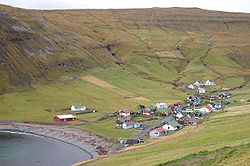
Dalur (Danish : Dal) is a village in the Faroe Islands. Dalur is located on the east-side of Sandoy. The village lies in the bottom of a relatively large valley. Dalur means valley in Faroese.

Contents

A little road leads from Dalur to the south-tip of the island. From there it is possible to walk to the bird cliffs Skorin. The church in Dalur was built in 1957 and this is the only church that has ever been here. [1]

See also

Related Research Articles

The politics of the Faroe Islands, an autonomous country of the Kingdom of Denmark, function within the framework of a parliamentary, representative democratic dependency, whereby the Prime Minister of the Faroe Islands is the head of government, and of a multi-party system. The Faroe Islands are politically associated with the Kingdom of Denmark but have been self-governing since 1948. Executive power is exercised by the government. Legislative power is vested in both the government and the Løgting. The judiciary is independent of the executive and the legislature and the responsibility of Denmark. As of October 25, 2007, the Faroe Islands became one electoral district.

<span class="mw-page-title-main">Transport in the Faroe Islands</span> Internal transport system of the Faroe Islands

The Faroe Islands is served by an internal transport system based on roads, ferries, and helicopters. As of the 1970s, the majority of the population centres of the Faroe Islands have been joined to a single road network, connected by bridges and tunnels.

<span class="mw-page-title-main">Kirkjubøur</span> Village in Faroe Islands, Kingdom of Denmark

Kirkjubøur is the southernmost village on Streymoy, Faroe Islands. The village is located on the south-west coast of Streymoy and has a view towards the islands of Hestur and Koltur towards the west, and to Sandoy towards the south. It lies south of the new ferry port of Gamlarætt, which opened in 1993.

<span class="mw-page-title-main">Suðuroy</span> Island in Faroe Islands, Kingdom of Denmark

Suðuroy is the southernmost of the Faroe Islands. The island covers 163.7 square kilometres (63.2 sq mi). In 2018 the population was 4,601. Suðuroy region (sýsla) comprises this island and Lítla Dímun, the next isle northward in the Faroes, which is uninhabited.

<span class="mw-page-title-main">Sandoy</span> Island in Faroe Islands, Kingdom of Denmark

Sandoy is the first of the five southern islands that make up the Faroe chain, the fifth biggest of all the Faroe Islands, an autonomous region of the Kingdom of Denmark. It also refers to the region that includes this island along with Skúvoy and Stóra Dímun. As of January 2020, the largest population centre on the island is the village of Sandur with a population of 532. Other settlements include Skarvanes, Skopun, Skálavík, Húsavík and Dalur.

<span class="mw-page-title-main">Streymoy</span> Island in Faroe Islands, Kingdom of Denmark

Streymoy is the largest and most populated island of the Faroe Islands. The capital, Tórshavn, is located on its southeast coast. The name means "island of currents". It also refers to the largest region of the country that also includes the islands of Hestur, Koltur and Nólsoy.

<span class="mw-page-title-main">Sandur, Faroe Islands</span> Municipality and village in Faroe Islands, Kingdom of Denmark

Sandur is a village on the south coast of the island of Sandoy in the Faroe Islands. The Sandur hoard of silver coins, dating to the end of the 11th century, attests to the long history of the village. In January 2020 the population stood at 532.

<span class="mw-page-title-main">Skúvoy, Skúvoy</span> Municipality and village in Faroe Islands, Kingdom of Denmark

The village Skúvoy lies on the east side of the island with the same name.

<span class="mw-page-title-main">Skopun</span> Town on the Faroe Islands, Denmark

Skopun is a town in the Faroe Islands situated on the northern coast of Sandoy.

<span class="mw-page-title-main">Velbastaður</span> Village in Faroe Islands, Kingdom of Denmark

Velbastaður is a village on the island of Streymoy in the Faroe Islands. It is a part of Tórshavn Municipality and is considered among the oldest settlements in the islands. There are two schools and one kindergarten in the village, with children coming from the neighboring village of Kirkjubø as well the capital at Tórshavn.

<span class="mw-page-title-main">Strandfaraskip Landsins</span> Government agency for public transport in the Faroe Islands

Strandfaraskip Landsins is the government agency for public transport in the Faroe Islands. It is owned by the Faroese national government under the Ministry of Finance (Fíggjamálaráðið) and runs eight ferry routes and a number of bus routes.

<span class="mw-page-title-main">Skálavík</span> Municipality and village in Faroe Islands, Kingdom of Denmark

Skálavík is a village and municipality on the eastern coast of the Faroese island Sandoy.

<span class="mw-page-title-main">Mjørkadalur</span> Place in Faroe Islands, Kingdom of Denmark

Mjørkadalur is a valley on the Faroese island of Streymoy in the Tórshavnar municipality. It has no postal code. It is located on the mountain of Sornfelli above the fjord of Kalbaksfjørður. The buildings in Mjørkadalur used to be part of the Island Command Faroes, but now a part of the building is used as a detention centre for prisoners who serve short sentences. Criminals from the Faroe Islands who serve longer sentences are sent to prisons in Denmark, as the detention centre only has room for 12 inmates.

<span class="mw-page-title-main">Faroe Islands</span> Danish territory in the North Atlantic Ocean

The Faroe or Faeroe Islands, or simply the Faroes, is a North Atlantic island group and an autonomous territory of the Kingdom of Denmark.

2012 Faroe Islands Premier League was the seventieth season of top-tier football on the Faroe Islands. For sponsorship reasons, it was known as Effodeildin. The season began on 24 March 2012 with a match between B36 Tórshavn and FC Suðuroy, and ended on 6 October 2012. EB/Streymur won their second league title. B36 Tórshavn were the defending champions.

<span class="mw-page-title-main">Húsavík Municipality</span> Place in Faroe Islands, Kingdom of Denmark

Húsavík Municipality is a municipality of the Faroe Islands. The town of Húsavík is the administrative centre.

The Suðuroyartunnilin is a proposed submerged fixed-link in the Faroe Islands, linking the island of Suðuroy to Sandoy. As of 2023, all vehicles and cargo, and virtually all passenger traffic must use the ferry service.

<span class="mw-page-title-main">Fjords in the Faroe Islands</span> List of fjords in the Faroe Islands

The Faroe Islands consist of 18 islands, several of which are deeply incised by fjords.

<span class="mw-page-title-main">Gamlarætt</span> Ferry port in the Faroe Islands

Gamlarætt is a ferry port in the Faroe Islands. It is situated on the southwestern side of the island of Streymoy, the largest island in the Faroes, between the villages of Velbastaður and Kirkjubøur. It accommodates ferry services to the islands of Sandoy and Hestur. The port is also used for local salmon farms.

References

  1. "Dalur". The Tourist Information Center in Sandoy. Retrieved June 8, 2010.