
Alberta's economy is the sum of all economic activity in Alberta, Canada's fourth largest province by population. Although Alberta has a presence in many industries such as agriculture, forestry, education, tourism, finance, and manufacturing, the politics and culture of the province have been closely tied to the production of fossil energy since the 1940s. Alberta—with an estimated 1.4 billion cubic metres of unconventional oil resource in the bituminous oil sands—leads Canada as an oil producer. Revenue from oil and natural gas extraction has fueled a series of economic booms in the province's recent history, and economic spin-offs have included petrochemical and pipelines. In 1985 36.1% of Alberta's $66.8 billion GDP was from energy industries. In 2012, "the mining and oil and gas extraction industry made up 23.3% of Alberta's GDP." By 2013 Alberta's GDP was $331.9 billion with 24.6% in energy. The energy industry provided 7.7% of all jobs in Alberta in 2013.

Crowsnest Pass is a low mountain pass across the Continental Divide of the Canadian Rockies on the Alberta–British Columbia border.

Events from the year 1857 in Canada.

Nordegg is a hamlet in west-central Alberta, Canada within Clearwater County. It is located in the North Saskatchewan River valley in the foothills of the Canadian Rockies, just east of the intersection of the David Thompson Highway and the Highway 734 spur of the Bighorn Highway. A former coal-mining town, it was named after Martin Nordegg and the name probably means "North Corner" in a German dialect.
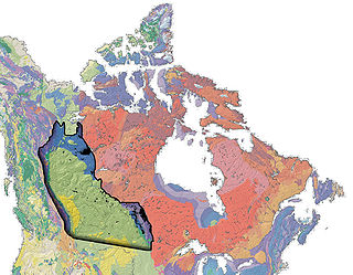
The Western Canadian Sedimentary Basin (WCSB) is a vast sedimentary basin underlying 1,400,000 square kilometres (540,000 sq mi) of Western Canada including southwestern Manitoba, southern Saskatchewan, Alberta, northeastern British Columbia and the southwest corner of the Northwest Territories. It consists of a massive wedge of sedimentary rock extending from the Rocky Mountains in the west to the Canadian Shield in the east. This wedge is about 6 kilometres (3.7 mi) thick under the Rocky Mountains, but thins to zero at its eastern margins. The WCSB contains one of the world's largest reserves of petroleum and natural gas and supplies much of the North American market, producing more than 16,000,000,000 cubic feet (450,000,000 m3) per day of gas in 2000. It also has huge reserves of coal. Of the provinces and territories within the WCSB, Alberta has most of the oil and gas reserves and almost all of the oil sands.
Cadomin is a hamlet in the west-central Alberta, Canada within Yellowhead County. It is located along the McLeod River in the foothills of the Rocky Mountains, approximately 50 kilometres (31 mi) south of Hinton near the Bighorn Highway. It is served by a spur of the Canadian National Railway.
Canada has access to all main sources of energy including oil and gas, coal, hydropower, biomass, solar, geothermal, wind, marine and nuclear. It is the world's second largest producer of uranium, third largest producer of hydro-electricity, fourth largest natural gas producer, and the fifth largest producer of crude oil. Only Russia, the People's Republic of China, the United States and Saudi Arabia produce more total energy than Canada.

Coal reserves in Canada rank thirteenth largest in the world at approximately 10 billion tons, 0.6% of the world total. This represents more energy than all of the oil and gas in the country combined. The coal industry generates CDN$5 billion annually. Most of Canada's coal mining occurs in the West of the country. British Columbia operates 10 coal mines, Alberta 9, Saskatchewan 3 and New Brunswick one. Nova Scotia operates several small-scale mines, Westray having closed following the 1992 disaster there.
The Viking Formation is a stratigraphical unit of Cretaceous age in the Western Canadian Sedimentary Basin.
The Paul First Nation, more commonly known as the Paul Band, is a First Nations band government based in Wabamun, Alberta of mixed Cree and Nakoda (Stoney) origin. They are party to Treaty Six and had the Buck Lake Indian Reserve 133C and Wabamun Lake Indian Reserve 133A, 133B and 133C allocated to them by the federal government in 1892. However the Buck Lake Reserve was decimated by the Spanish Flu of 1918 and is now largely abandoned.
The Ardley is a large coal field located in the western part of Canada in Alberta. Ardley represents one of the largest coal reserve in Canada having estimated reserves of 596 billion tonnes of coal.
The Drumheller is a large coal field located in the western part of Canada in Alberta. Drumheller represents one of the largest coal reserve in Canada having estimated reserves of 564 billion tonnes of coal.
The Mannville is a large coal field located in the western part of Canada in Alberta. Mannville represents one of the largest coal reserve in Canada having estimated reserves of 570 billion tonnes of coal.
The MacKay is a large coal field located in the western part of Canada in Alberta. MacKay represents one of the largest coal reserve in Canada having estimated reserves of 403 billion tonnes of coal.
The Taber is a large coal field located in the western part of Canada in Alberta. Taber represents one of the largest coal reserve in Canada having estimated reserves of 335 billion tonnes of coal.
The Lethbridge is a large coal field located in the western part of Canada in Alberta. Lethbridge represents one of the largest coal reserve in Canada having estimated reserves of 277 billion tonnes of coal.
The Carbon-Thompson is a large coal field located in the western part of Canada in Alberta. Carbon-Thompson represents one of the largest coal reserve in Canada having estimated reserves of 183 billion tonnes of coal.
The Gething is a large coal field located in the western part of Canada in Alberta. Gething represents one of the largest coal reserve in Canada having estimated reserves of 13 billion tonnes of coal.


