Damghar Yousafzai is a village in the Swat District of Khyber Pakhtunkhwa, Pakistan. It is located adjacent to the Swat River.
Damghar Yousafzai is a village in the Swat District of Khyber Pakhtunkhwa, Pakistan. It is located adjacent to the Swat River.

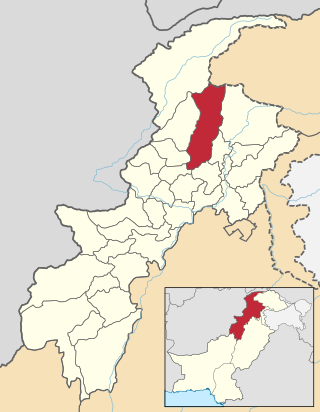
Buner District is a district in Malakand Division of Khyber Pakhtunkhwa province in Pakistan. Before becoming a district in 1991, it was a tehsil within Swat District.
Alpuri is the capital of Shangla District in the Khyber-Pakhtunkhwa province of Pakistan. It is located at 34°54′00″N72°39′00″E and has an average elevation of 1587 meters. The place has a government degree college and District headquarters hospital.

Kabal is a town in Swat District, Khyber-Pakhtunkhwa province of Pakistan located 10 kilometres (6 mi) from Mingora city. The old name of kabal was Chendakhwara. It is the tenth largest city in Khyber Pakhtunkhwa and 82nd largest in Pakistan by population.

Besham is a city in the Shangla District of Khyber Pakhtunkhwa, Pakistan. Located on the right bank of the Indus River, Besham serves as a major junction on the Karakoram Highway, that connects Khyber Pakhtunkhwa and Punjab with Gilgit-Baltistan, and crosses over into China's Xinjiang. Besham is also the eastern terminus of the under-construction E90 expressway, which will connect the city westward with Khwazakhela in Swat District. Besham is located around 60 kilometres (40 mi) east of Swat, 250 kilometres (160 mi) north of Rawalpindi-Islamabad, and 270 kilometres (170 mi) northeast of the provincial capital, Peshawar, Pakistan.
The 23 August 2008 Swat Valley bombing occurred on 23 August 2008 when a suicide bomber rammed an explosive-laden car into a police station in Charbagh Tehsil of Swat valley of North West Frontier Province killing 20 people. The Tehrik-e-Taleban organisation claimed responsibility.
Charguli or Chargul is a town and union council in Mardan District of Khyber-Pakhtunkhwa. It has one Basic Health Unit, Government Primary, Middle & Higher Secondary School for Girls & Boys. There are 4 private schools. One Govt. Technical & Vocational Center is recently shipped here offering various kind of technical courses.

Ghalegay is a village of Swat Valley, located at a distance of 14 km south of Mingora, on the left bank of Swat River. It is one of the main villages lying between the two cities, Mingora and Barikot.

Charbagh is a town in Tehsil Charbagh, in the Khyber Pakhtunkhwa province of Pakistan. It is part of Swat District and is located at 34°50'0"N 72°26'30"E with an average altitude of 1,032 meters. It is located on the N-95 National Highway some 15 km from mingora in Khyber Pakhtunkhwa.
Guljabba is a village in Swat [Swat District of Khyber Pakhtunkhwa]. It is located at 34°48'0N 72°17'30E with an altitude of 880 metres. Neighbouring settlements include [Hazara, in Swat] and [Kabbal].
Ningolai is a village in swat(Khyber Pakhtoon Khwa) Pakistan. Old name was Ningula which was named by a person name Ningula. Later it was named Ningolai by the Rular of Swat State. The people of village Ningolai belong to subsection Naikpikhel of Yusufzai the biggest and largest tribe of Pashtun tribes. The village contains a small series of mountains and a forest, residential area starting from meadows of mountainsand merge with river swat on right bank, vast land for crops, number of canals, and a part of the Swat river. Mountains of the village include Usmani Ghar, Kursi Ghat, Kafar Ghat and Najia.
Hazara Swat is a village and District Swat Tehsil Kabal located 7 km away from main Minogra city. Hazara Village has pretty much advantage over other villages in swat as there are government schools, few private schools and private hospitals.
Kuza Bandai is a well developed village in Swat Valley of Khyber Pakhtunkhwa, Pakistan. It is known for its natural environment and also known as an area crossed by Alexander the Great. Later, after the Lal Masjid battle, Kuza Bandai and Bara Bandai became sympathetic to the Taliban movement. The village consists of Yusufzai Pakhtun tribes. It is one of Pakistan's Provincially Administered Tribal Areas (PATA).

Sultan Mahmud Ghaznavi Mosque is one of the oldest mosques in northern Pakistan, discovered by the Italian Archaeological Mission in Pakistan in 1985. The mosque represents a splendid design of old Muslim architecture.
Aboha Is a village in the Union Council of Kota Swat, Tehsil Barikot in Swat District, Khayber Pukhtoonkhwa. It is located on the gateway to main city of Swat on the main G.T road.
Bar Abakhel is an administrative unit, known as the Union council, of Swat District in the Khyber Pakhtunkhwa province of Pakistan. District Swat has 9 Tehsils i.e. Khwazakhela, Kabal, Madyan, Barikot, Mingora, and Kalam. Each Tehsill comprises certain numbers of union councils. There are 65 union councils in district Swat, 56 rural and 09 urban.
Gulkada is an administrative unit, known as Union council in Tehsil Babuzai, or Wards of Swat District in the Khyber Pakhtunkhwa province of Pakistan.
KotanaiKhwazakhela is an administrative unit, known as Union council, of Swat District in the Khyber Pakhtunkhwa province of Pakistan. District Swat has 9 Tehsils i.e. Khwazakhela, Kabal, Madyan, Barikot, Mingora, and Kalam. Each Tehsill comprises certain numbers of union councils. There are 65 union councils in district Swat, 56 rural and 09 urban.
Dangram Sangota is an administrative unit, known as Union council in Tehsil Babuzai, or Wards of Swat District in the Khyber Pakhtunkhwa province of Pakistan.
Shalpin is an administrative unit, known as Union council, of Swat District in the Khyber Pakhtunkhwa province of Pakistan. Union council Shalpin has 3 village councils i.e. Shalpin, Faqira and Bawrai. Village council Faqira includes the following villages: Faqira, Banda, Sholgara and Karal etc. Shalpin is a village of Swat District situated 32 kilometres away from Mingaora. Elevation of the area is 4,300 ft. The most cultivated crops of the area are Wheat and Maize. Shalpin is also famous for its fruits like Peaches locally named is Shaltaloo, Apricots and Persimons. The Shalpin valley is diverse in vegetation. Pashtu is the most common language although few families in the mountain areas maybe speaking kohistani and gujri. Shalpin has a public high School for boys and girls and two private middle Schools. Shalpin also has a basic health Unit. People of Shalpin are highly educated and several alumni of high school are serving at different key positions in the country and abroad.
Swat Sports Complex is located in Swat, Khyber Pakhtunkhwa province in Pakistan. The Sports Complex was formally opened on 29, November 2010.
Coordinates: 34°48′07.8″N72°21′25.2″E / 34.802167°N 72.357000°E
| | This Swat District location article is a stub. You can help Wikipedia by expanding it. |