Dapani

Last updated
Dapani
Village
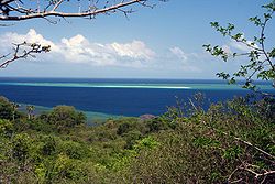
Ilot-Sable-Blanc-pointe-Saziley.jpg
Saziley Point, east of Dapani
Mayotte blank map.svg
Red pog.svg
Dapani
Coordinates: 12°58′17″S45°9′39″E / 12.97139°S 45.16083°E / -12.97139; 45.16083
CountryFlag of France.svg  France
Overseas Territory Mayotte
Commune Bandrele
Area
  Total3.646 km2 (1.408 sq mi)

Dapani is a village in the commune of Bandrele on Mayotte. It is located near the Pointes et plages de Saziley et Charifou protected area on the south-east of Mayotte. The protected area includes Dapani Beach and mangroves, and is a notable bird habitat known for its "botanical trail" through the mangroves.

Two locals on the beach in Dapani Mahoraises-plage-Dapani.jpg
Two locals on the beach in Dapani

Related Research Articles

Glorioso Islands Archipelago in the Scattered Islands in the Indian Ocean

The Glorieuses or Glorioso Islands are a group of French islands and rocks totaling 5 square kilometres. They are controlled by France as part of the Scattered Islands in the Indian Ocean in the French Southern and Antarctic Lands, a French overseas territory, but are also claimed by Comoros, Madagascar and formerly by Seychelles. They are geographically part of the Comoro Islands between the French overseas region of Mayotte and the nation of Madagascar.

Mayotte Overseas department of France in the Indian Ocean

Mayotte is an overseas department and region and single territorial collectivity of France officially named the Department of Mayotte. It is located in the northern part of the Mozambique Channel in the Indian Ocean off the coast of Southeastern Africa, between Northwestern Madagascar and Northeastern Mozambique. Mayotte consists of a main island, Grande-Terre, a smaller island, Petite-Terre, as well as several islets around these two. Mayotte is the most prosperous territory in the Mozambique Channel, making it a major destination for illegal immigration.

Geography of Mayotte Island of volcanic origin in Mozambique

Mayotte is an island of volcanic origin in the northernmost Mozambique Channel, about one-half of the way from northern Madagascar to northern Mozambique. Mayotte is part of the Comoro Islands, and like them is the result of a former hot spot, the oldest of the Comoros archipelago, formed about 7.7 mya. Mayotte has an area of 374 square kilometres, and a coastline of length 185.2 km. Its maritime claims are an exclusive economic zone of 200 nautical miles, and a territorial sea of 12 nm.

Comoro Islands Archipelago in the Indian Ocean, off the coast of Africa

The Comoro Islands or Comoros form an archipelago of volcanic islands situated off the southeastern coast of Africa, to the east of Mozambique and northwest of Madagascar. The islands are politically divided between the Union of the Comoros, a sovereign country, and Mayotte, an Overseas Department of France.

Sundarbans Reserved Forest in Bengal

Sundarbans is a mangrove area in the delta formed by the confluence of the Padma, Brahmaputra and Meghna Rivers in the Bay of Bengal. It spans the area from the Baleswar River in Bangladesh's division of Khulna to the Hooghly River in India's state of West Bengal. It comprises closed and open mangrove forests, land used for agricultural purpose, mudflats and barren land, and is intersected by multiple tidal streams and channels. Four protected areas in the Sundarbans are enlisted as UNESCO World Heritage Sites, viz. Sundarbans West (Bangladesh), Sundarbans South (Bangladesh), Sundarbans East (Bangladesh) and Sundarbans National Park (India).

Mangrove Creek Dam, a concrete faced rockfill embankment dam, is the primary reservoir for water supply to residents of the Central Coast in New South Wales, Australia.

Goshen is a Canadian rural community in Guysborough County, Nova Scotia.

Mayotte white-eye Species of bird

The Mayotte white-eye or chestnut-sided white-eye is a species of bird in the family Zosteropidae. It is now found only on Mayotte in the Comoro Islands. Its natural habitats are subtropical or tropical dry forests, subtropical or tropical moist lowland forests, and subtropical or tropical mangrove forests.

Handrema is the smallest village in the commune of Bandraboua on Mayotte. In 2007, its population was 1,485.

Comoros forests Ecoregion in Mexico and Central America

The Comoros forests is a terrestrial ecoregion which covers the Comoro Islands, which lie in the Mozambique Channel between Madagascar and East Africa. These include four main islands: Grande Comore, Anjouan and Mohéli, of the Union of the Comoros, and Mayotte, a department and region of France.

Central African mangroves Largest area of mangrove swamp in Africa, located on the coasts of West Africa, mainly in Nigeria

The Central African mangroves ecoregion consists of the largest area of mangrove swamp in Africa, located on the coasts of West Africa, mainly in Nigeria.

East African mangroves Mangrove swamps on the Indian Ocean coast of East Africa

The East African mangroves are a mangrove ecoregion consisting of swamps along the Indian Ocean coast of East Africa in Mozambique, Tanzania, Kenya and southern Somalia.

Southern Africa mangroves Ecoregion of mangrove swamps in rivers and estuaries on the eastern coast of South Africa

The Southern Africa mangroves are mangrove ecoregion on the Mozambique's southernmost coast and the eastern coast of South Africa.

Ecological values of mangroves

Mangrove ecosystems represent natural capital capable of producing a wide range of goods and services for coastal environments and communities and society as a whole. Some of these outputs, such as timber, are freely exchanged in formal markets. Value is determined in these markets through exchange and quantified in terms of price. Mangroves are important for aquatic life and home for many species of fish.

Ghisolfa is a district ("quartiere") of Milan, Italy, part of the Zone 8 administrative division of the city, located north-west of the city centre. It is named after the "Ghisolfa Bridge" overpass, part of the external Circonvallazione ring road enclosing the centre of Milan. In turn, the bridge was named after two cascine, "Cascina Ghisolfa" and "Cascina Ghisolfetta", that existed in the area before the urbanization of the mid 20th century. The bridge was completed in 1941, prolonged in the 1960s, and enlarged in the 1990s.

Pointes et plages de Saziley et Charifou

Pointes et plages de Saziley et Charifou is a protected area in Mayotte, a French island territory in the Comoro archipelago of the western Indian Ocean. It was established in 1997.

Mayotte chameleon Species of lizard

The Mayotte chameleon is a species of chameleon that is endemic to Mayotte in the Comoros Islands. It was first described by Wilhelm Peters in 1874.

Baie de Bouéni

The Baie de Bouéni is a large bay in the south-west of the French island territory of Mayotte, in the Comoro Islands lying at the northern end of the Mozambique Channel between the East African country of Mozambique and Madagascar. It is about 5 km wide at its mouth, and 10 km in length. It was made a protected area in 2007.

COVID-19 pandemic in Mayotte Ongoing COVID-19 viral pandemic in Mayotte, France

The ongoing COVID-19 pandemic was confirmed to have reached the French overseas department and region of Mayotte on 10 March 2020. On 31 March, the first person died of COVID-19. In late April, the virus was out of control, and actively circulating on the island. On 16 August, Mayotte has been green listed.

Mayotte Marine Natural Park Marine Park in the Comoro Islands

The Mayotte Marine Natural Park is a marine park surrounding Mayotte, a French overseas region. Mayotte is part of the Comoro Islands archipelago, which lies within the Mozambique Channel in the western Indian Ocean. Established in 2010, the park covers the entirety of Mayotte's territorial waters and exclusive economic zone. It is contiguous with the Glorioso Islands Marine Natural Park, which was established two years later.

References

    Coordinates: 12°58′17″S45°9′39″E / 12.97139°S 45.16083°E / -12.97139; 45.16083