
Hiriyur is a town and taluk headquarters located near Chitradurga in the Indian state of Karnataka.

Kanakapura is a city and the headquarters of Kanakapura Taluk in the Ramanagara district in the state of Karnataka, India. Situated 55 km from the city Bengaluru, this city is famous for the production of silk and granite. It is located among the lush green forests of the state of Karnataka and The town is a tourism hotspot and an often visited tourist favorite in the entire state of Karnataka, as it has something for everyone ranging from avid trekkers to history buffs and wildlife enthusiasts.

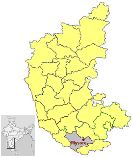
Bannur is a panchayat town in Mysore district (ಮೈಸೂರು) in the state of Karnataka, India. Bannur is the birthplace of Vyasatirtha, a previous avatara of Sri Raghavendra Swamy, Mantralaya.

Hunsur is town in Mysore district in the Indian state of Karnataka. It is the headquarter of the Hunsur Taluk administrative division.

Turuvekere is a panchayat town and Taluk in Tumkur district in the Indian state of Karnataka.
Algodu is a village in the southern state of Karnataka, India. It is located in the Tirumakudal Narsipur taluk of Mysore district.
Udburu is a village in the southern state of Karnataka, India. It is located in the Mysore taluk of Mysore district in Karnataka.
Adibettahalli is a village in the southern state of Karnataka, India. It is located in the Tirumakudal Narsipur taluk of Mysore district in Karnataka.
Yachenahalli is a panchayat town in Mysore district in the state of Karnataka, India.
Saligrama (ಸಾಲಿಗ್ರಾಮ) is the 5th biggest village by area in the sub district and is situated on the north bank of the river Cauvery [Kaveri], this place is esteemed as sacred by the Shri Vaishnavas on account of its having been the residence of Sri Ramanujacharya. It is a hobli with PIN code 571604, is in K R Nagara [Krishnarajanagara] taluk, in the Mysuru district [Mysore district] of Karnataka, India.
Talikoti also Talikota (Talikot) is a town in Vijaypur district in the northern part of the Indian state of Karnataka, about 85 kilometres to the southeast of Vijaypur city. It lies on the river called Doni. It is famous for the Battle of Talikoti in 1565.

Kenchalagudu is a small village near manandavadi road Mysore city in Karnataka province of India.

Jayapura is a small village near Mysore in Karnatakaprovince, India.

Mandanhalli is a small village near Mysore in Karnataka province of India.

Jeemaralli or Biligere is a small village in Nanjangud taluk of Mysore district in Karnataka state, India.

Konanur or Paduvalamarahalli is a village in Nanjangud taluk of Mysore district, Karnataka state, India.
Naganahalli is a small village in Mysuru district of Karnataka state, India.

Chikkalli Choranalli is a twin village near Mysore city, Karnataka state, India.

Kodagahalli is a small village in Mysore district of Karnataka state, India.

Bherya is a village in Mysore district of Karnataka State, India.


