
Beaverton is a city in Washington County, in the U.S. state of Oregon that is located 7 miles (11 km) west of Portland in the Tualatin Valley. The city is among the main cities that make up the Portland metropolitan area. Its population was 89,803 at the 2010 census, making it the second-largest city in the county and the sixth-largest city in Oregon. Beaverton is an economic center for Washington County along with neighboring Hillsboro. It is home to the world headquarters of Nike, Inc., although it sits outside of city limits on unincorporated county land.

The United States Census Bureau (USCB), officially the Bureau of the Census, is a principal agency of the U.S. Federal Statistical System, responsible for producing data about the American people and economy. The Census Bureau is part of the U.S. Department of Commerce and its director is appointed by the President of the United States.

A metropolitan area or metro is a region consisting of a densely populated urban core and its less-populated surrounding territories sharing industries, commercial areas, transport network, infrastructures and housing. A metro area usually comprises multiple jurisdictions and municipalities: neighborhoods, townships, boroughs, cities, towns, exurbs, suburbs, counties, districts, and even states and nations like the eurodistricts. As social, economic and political institutions have changed, metropolitan areas have become key economic and political regions.

Newton is a city in Middlesex County, Massachusetts, United States. It is approximately 7 miles (11 km) west of downtown Boston. Newton resembles a patchwork of thirteen villages, without a city center. According to the 2020 U.S. Census, the population of Newton was 88,923.

Washington, D.C., formally the District of Columbia (D.C.), also known as just Washington, is the capital city of the United States. It is located on the east bank of the Potomac River which forms its southwestern and southern border with the U.S. state of Virginia, and shares a land border with the U.S. state of Maryland on its remaining sides. The city was named for George Washington, the first president of the United States and a Founding Father, and the federal district is named after Columbia, a female personification of the nation. As the seat of the U.S. federal government and several international organizations, the city is an important world political capital. It is one of the most visited cities in the U.S., seeing over 20 million visitors in 2016.
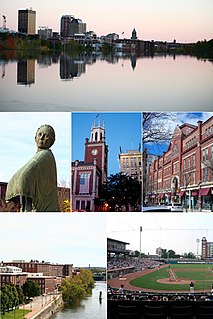
Manchester is a city in Hillsborough County in southern New Hampshire, United States. It is the most populous city in northern New England. As of the 2020 census, the city had a population of 115,644.

Hermiston is a city in Umatilla County, Oregon, United States. Its population of 19,696 makes it the largest city in Eastern Oregon. Hermiston is the largest, and fastest-growing, city in the Hermiston-Pendleton Micropolitan Statistical Area, the eighth largest Core Based Statistical Area in Oregon with a combined population of 92,261 at the 2020 census. Hermiston sits near the junction of I-82 and I-84, and is 7 miles south of the Columbia River, Lake Wallula, and the McNary Dam. The Hermiston area has become a hub for logistics and data center activity due to the proximity of the I-82 and I-84 interchange, Pacific Northwest fiber optic backbone, and low power costs. The city is also known for its watermelons, which are part of its branding.

Tysons, also known as Tysons Corner, is a census-designated place (CDP) and unincorporated community in Fairfax County, Virginia, United States. Located in Northern Virginia between the community of McLean and the town of Vienna along the Capital Beltway (I-495), it lies within the Washington Metropolitan Area. Tysons is home to two super-regional shopping malls—Tysons Corner Center and Tysons Galleria—and the corporate headquarters of numerous companies such as Alarm.com, Booz Allen Hamilton, Capital One, DXC Technology, Freddie Mac, Gannett, Hilton Worldwide, Intelsat and Tegna. Tysons is Fairfax County's central business district and a regional commercial center. It has been characterized as a quintessential example of an edge city. The population was 26,374 as of the 2020 census.

Barrie is a city in Ontario, Canada. It is located on the shores of Kempenfelt Bay, the western arm of Lake Simcoe. It is a politically independent single-tier municipality within Simcoe County. Barrie is part of the extended urban area in southern Ontario known as the Greater Golden Horseshoe. As of the 2016 census, the city's population was 141,434, while the census metropolitan area centred on the city had a population of 197,059 residents.

The Dallas–Fort Worth metroplex, officially designated Dallas–Fort Worth–Arlington by the U.S. Office of Management and Budget, is a conurbated metropolitan statistical area in the U.S. state of Texas encompassing 11 counties. It is the economic and cultural hub of North Texas. Residents of the area also refer to it as DFW, or the Metroplex. The Dallas–Fort Worth–Arlington metropolitan statistical area's population was 7,637,387 according to the U.S. Census Bureau's 2020 census, making it the most populous metropolitan area in both Texas and the Southern United States, the fourth-largest in the U.S., and the tenth-largest in the Americas. In 2016, the Dallas–Fort Worth metroplex had the highest annual population growth in the United States.

The Wasatch Front is a metropolitan region in the north-central part of the U.S. state of Utah. It consists of a chain of contiguous cities and towns stretched along the Wasatch Range from approximately Nephi in the south to Brigham City in the north. Roughly 80% of Utah's population resides in this region, which contains the major cities of Salt Lake City, West Valley City, Provo, West Jordan, Layton, and Ogden.

An urban area, or built-up area, is a human settlement with a high population density and infrastructure of built environment. Urban areas are created through urbanization and are categorized by urban morphology as cities, towns, conurbations or suburbs. In urbanism, the term contrasts to rural areas such as villages and hamlets; in urban sociology or urban anthropology it contrasts with natural environment. The creation of early predecessors of urban areas during the urban revolution led to the creation of human civilization with modern urban planning, which along with other human activities such as exploitation of natural resources led to a human impact on the environment. "Agglomeration effects" are in the list of the main consequences of increased rates of firm creation since. This is due to conditions created by a greater level of industrial activity in a given region. However, a favorable environment for human capital development would also be generated simultaneously.
The southeastern United States, also referred to as the American Southeast or simply the Southeast, is broadly the eastern portion of the southern United States and the southern portion of the eastern United States. It comprises at least a core of states on the lower East Coast of the United States and eastern Gulf Coast. Expansively, it includes everything south of the Mason–Dixon line, the Ohio River, the 36°30' parallel, and stretches far west as Arkansas and Louisiana. There is no official U.S. government definition of the region, though various agencies and departments use different definitions.

The Harrisburg–Carlisle metropolitan statistical area, officially the Harrisburg–Carlisle, PA Metropolitan Statistical Area, and also referred to as the Susquehanna Valley, is defined by the Office of Management and Budget as an area consisting of three counties in South Central Pennsylvania, anchored by the cities of Harrisburg and Carlisle. As of the 2010 census, the metropolitan statistical area (MSA) had a population of 549,475. In 2010, Harrisburg–Carlisle was the 96th largest metropolitan area in the United States. Since 2012, it has been defined as part of the Harrisburg–York–Lebanon, PA Combined Statistical Area, which also includes York, Lebanon and Adams counties.

The Youngstown–Warren–Boardman, OH–PA Metropolitan Statistical Area, typically known as the Mahoning Valley or the Steel Valley, is a metropolitan area in Northeast Ohio and Western Pennsylvania the United States, with the city of Youngstown, Ohio, at its center. According to the US Census Bureau, the metropolitan statistical area (MSA) includes Mahoning and Trumbull counties in Ohio and Mercer County in Pennsylvania. As of the 2020 census, the metro area had a population of 541,243. This area has a large commuter population that works in Cleveland and Pittsburgh and their metropolitan areas. It is located in the Rust Belt, a region which stretches from Minneapolis in the west to Scranton in the east.
The District of Columbia is a federal district with an ethnically diverse population. In 2018, the District had a population of 702,455 people, with a resident density of 11,515 people per square mile.
The Hagerstown–Martinsburg Metropolitan Area, officially designated by the United States Office of Management and Budget (OMB) as Hagerstown–Martinsburg, Maryland–West Virginia Metropolitan Statistical Area (MSA), constitutes the primary cities of Hagerstown, Maryland, Martinsburg, West Virginia, and surrounding areas in three counties: Washington County, Maryland, Berkeley County, West Virginia, and Morgan County, West Virginia. The metro area lies mainly within the rich, fertile Cumberland and Shenandoah valleys, and is approximately a 60–90 minute drive from Washington, D.C., Baltimore, Maryland, and Harrisburg, Pennsylvania; Hagerstown is approximately 75 miles (121 km) driving distance from all three cities. The population of the metropolitan area as of 2008 is 263,753.

A commuter town is a populated area that is primarily residential, rather than commercial or industrial. Routine travel from home to work and then from work to home is called commuting, which is where the term comes from. A commuter town may be called by many other terms: "bedroom community", "bedroom town", "bedroom suburb" (US), "dormitory town", "dormitory suburb" or "dormitory village" (Britain/Commonwealth/Ireland). In Japan, a commuter town may be referred to with the wasei-eigo coinage "bed town". The term "exurb" was also used from the 1950s, but since 2006, is generally used for areas beyond suburbs and specifically less densely built than the suburbs to which the exurbs' residents commute.
The United States federal government defines and delineates the nation's metropolitan areas for statistical purposes, using a set of standard statistical area definitions. As of 2020, the U.S. Office of Management and Budget (OMB) defined and delineated 392 metropolitan statistical areas (MSAs) and 547 micropolitan statistical areas (μSAs) in the United States and Puerto Rico. Many of these 939 MSAs and μSAs are, in turn, components of larger combined statistical areas (CSAs) consisting of adjacent MSAs and μSAs that are linked by commuting ties; as of 2020, 551 metropolitan and micropolitan areas are components of the 175 defined CSAs. A collective term for MSAs, μSAs, and CSAs is primary statistical areas (PSAs), though that term is not used by OMB.
