Related Research Articles
Deadman's Bay is a local service district and designated place in the Canadian province of Newfoundland and Labrador. It is on the Straight Shore of Bonavista Bay near the community of Lumsden. The community is located near fishing grounds, contributing to its diversified and successful fishery despite its exposed, sandy coastline and harsh fall storms.
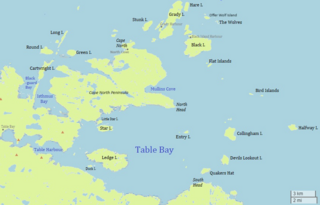
Table Bay is a natural bay and former community on the coast of Labrador in the province of Newfoundland and Labrador, Canada. It drains into the Labrador Sea to the east.
Sandy Bay is a natural bay off the island of Newfoundland in the province of Newfoundland and Labrador, Canada.
Rocky Bay is a natural bay off the island of Newfoundland in the province of Newfoundland and Labrador, Canada. It lies to the north of Caplin Bay and to the south of Partridge Bay, opening to the Labrador Sea.
Shoal Bay is a natural bay off the island of Newfoundland in the province of Newfoundland and Labrador, Canada.
Indian Bay is a natural bay off the island of Newfoundland in the province of Newfoundland and Labrador, Canada.
Lockers Bay is a natural bay off the island of Newfoundland in the province of Newfoundland and Labrador, Canada.
Damnable Bay is a natural bay off the island of Newfoundland in the province of Newfoundland and Labrador, Canada.
Goose Bay is a natural bay off the island of Newfoundland in the province of Newfoundland and Labrador, Canada.
Blackhead Bay is a natural bay off the island of Newfoundland in the province of Newfoundland and Labrador, Canada. It is a side bay of Bonavista Bay.
Robinhood Bay is a natural bay off the island of Newfoundland in the province of Newfoundland and Labrador, Canada. It cuts into the southern shore of Bonavista Peninsula and opens into Trinity Bay. The town of Port Rexton is situated at the north end of the bay.
Tickle Bay is a natural bay off the island of Newfoundland in the province of Newfoundland and Labrador, Canada.
Hopeall Bay is a natural bay off the island of Newfoundland in the province of Newfoundland and Labrador, Canada. It is an arm of Trinity Bay, which in turn opens to the Atlantic Ocean.
Carbonear Bay is a natural bay off the island of Newfoundland, located in the province of Newfoundland and Labrador, Canada. The bay is also home to Carbonear Island.

Spaniard's Bay is a natural bay off the island of Newfoundland in the province of Newfoundland and Labrador, Canada. It extends from Conception Bay into the northern section of the Avalon Peninsula.
Bay de Grave is a natural bay off the island of Newfoundland in the province of Newfoundland and Labrador, Canada.
Collier Bay is a natural bay off the island of Newfoundland in the province of Newfoundland and Labrador, Canada.
Partridge Bay is a natural bay on the coast of Labrador in the province of Newfoundland and Labrador, Canada. It lies to the north of Rocky Bay and to the south of Shoal Bay, with several small uninhabited islands across its entrance from the Labrador Sea.
Black Bear Bay is a natural bay on the coast of Labrador in the province of Newfoundland and Labrador, Canada.
Sandwich Bay is a natural bay on the coast of Labrador in the province of Newfoundland and Labrador, Canada. The principal permanent settlement is Cartwright, located at the south entrance to the inner part of the bay. Other settlements along the bay include Paradise River and North River. Both of these communities are located at the outlets of the rivers of the same name into the bay. There is a road following the entire eastern coastline of Sandwich Bay, Newfoundland and Labrador Route 516.
References
- ↑ United States Hydrographic Office; Davenport, Richard G. (1884). Newfoundland and Labrador: The coast and banks of Newfoundland and the coast of Labrador, from Grand Point to the Koksoak River, with the adjacent islands and banks (Public domain ed.). Govt. print. off. pp. 338–. Retrieved 20 November 2011.
49°19′59″N53°39′50″W / 49.333°N 53.664°W
| | This Newfoundland and Labrador location article is a stub. You can help Wikipedia by expanding it. |