
The San Juan Islands is an archipelago in the Pacific Northwest of the United States between the U.S. state of Washington and Vancouver Island, British Columbia, Canada. The San Juan Islands are part of Washington state, and form the core of San Juan County.

The San Juan Mountains is a high and rugged mountain range in the Rocky Mountains in southwestern Colorado and northwestern New Mexico. The area is highly mineralized and figured in the gold and silver mining industry of early Colorado. Major towns, all old mining camps, include Creede, Lake City, Silverton, Ouray, and Telluride. Large scale mining has ended in the region, although independent prospectors still work claims throughout the range. The last large scale mines were the Sunnyside Mine near Silverton, which operated until late in the 20th century and the Idarado Mine on Red Mountain Pass that closed down in the 1970s. Famous old San Juan mines include the Camp Bird and Smuggler Union mines, both located between Telluride and Ouray.
San Juan County is a county located in the Salish Sea in the far northwestern corner of the U.S. state of Washington. As of the 2020 census, its population was 17,788. The county seat and only incorporated town is Friday Harbor, located on San Juan Island. The county was formed on October 31, 1873, from Whatcom County and is named for the San Juan Islands, which are in turn named for Juan Vicente de Güemes, 2nd Count of Revillagigedo, the Viceroy of New Spain.

San Juan Island is the second-largest and most populous of the San Juan Islands in northwestern Washington, United States. It has a land area of 142.59 km2 and a population of 8,632 as of the 2020 census.

Orcas Island is the largest of the San Juan Islands of the Pacific Northwest, in northwestern Washington, United States.

Sucia Island is located 2.5 miles (4.0 km) north of Orcas Island in the San Juan Islands, San Juan County, Washington, United States. It is the largest of an archipelago of ten islands including Sucia Island, Little Sucia, Ewing, Justice, Herndon, the Cluster Islands islets, and several smaller, unnamed islands. The group of islands is about 2.5 miles (4.0 km) in length and just short of a half mile wide. Sucia island is roughly the shape of a hand. The total land area of all islands is 2.74 km2. The main island of Sucia Island by itself is 2.259 km2. There was a permanent population of four persons as of the 2000 census, all on Sucia Island. Sucia Island State Park is a Washington State Marine Park.
Goose Island is one of the San Juan Islands in San Juan County, Washington, United States.

Blakely Island in San Juan County, Washington is the sixth largest island in the San Juan Islands of Washington State, United States, encompassing a land area of 16.852 km2. It is separated from Cypress Island to the east by Rosario Strait. The population was 56 persons as of the 2000 census.
Deadman's Island or variations on the name may refer to:
California's 24th congressional district is a congressional district in the U.S. state of California. The district is currently represented by Salud Carbajal. It contains all of Santa Barbara County, most of San Luis Obispo County, and part of Ventura County. Cities in the district include Santa Barbara, Ventura, San Luis Obispo, Santa Maria, and Ojai.
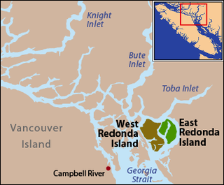
East Redonda Island is a coastal island in British Columbia, Canada, part of the Discovery Islands archipelago. It lies just to the north of Desolation Sound Marine Park, which is located off the north end of the Malaspina Peninsula at the mouth of Toba Inlet within Electoral Area C of the Strathcona Regional District.
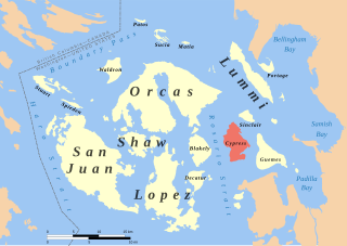
Cypress Island is the westernmost part of Skagit County, Washington and is about halfway between the mainland and offshore San Juan County. It is separated from Blakely Island to the west by Rosario Strait and from Guemes Island to the east by Bellingham Channel. The island has a land area of 5,500 acres (22 km2), and a population of 40 persons as of the 2000 United States Census.
Crane Island is one of the San Juan Islands in San Juan County, Washington, United States. It lies just off the southwestern shore of Orcas Island, between it and the northwest corner of Shaw Island. Crane Island has a land area of 0.956 km². The 2000 census reported a population of 20 permanent residents.
Henry Island is one of the San Juan Islands of San Juan County, Washington, United States. It lies just off the northwest shore of San Juan Island. The small Pearl Island also lies between Henry Island and San Juan Island at its northern end. Just northwest of the northern tip of Henry Island lies Battleship Island, a State bird sanctuary. Except for Stuart Island, Henry Island is the westernmost of the San Juan Islands. It has a land area of 4.126 km² and had a total of19 permanent residents as of the 2010 census.
Brown Island is a small, private island in Friday Harbor on San Juan Island, San Juan County, Washington, United States. It lies just offshore to the east-northeast of the town of Friday Harbor, Washington. The island has a land area of approximately 70 acres (28 ha) and on January 1, 2008, it had a resident full-time population of 10 people.

Clark Island is an island in the San Juan Islands of the Pacific Northwest, located near Barnes Island off the northeast coast of Orcas Island. It is part of the U.S. state of Washington. Clark Island Marine State Park, which encompasses the entire 55-acre (22 ha) island, has two picnicking sites, 15 primitive campsites, and nine mooring buoys.

The San Juan Islands National Wildlife Refuge is in the San Juan Islands of the Salish Sea, north of Puget Sound, in the State of Washington. Created in 1976, it comprises 83 small, uninhabited islands, scattered throughout the San Juans, with a combined area of approximately 454 acres (1.84 km2). The Refuge is managed by the U.S. Fish and Wildlife Service as one of six in the Washington Maritime National Wildlife Refuge Complex.
Blind Island Marine State Park is a public recreation area consisting of the entirety of Blind Island, a three-acre (1.2 ha) island at the entrance to Blind Bay on Shaw Island in San Juan County, Washington. It is part of the San Juan Islands National Monument. The island lies one-third of a mile west of the Shaw Island ferry terminal and has 1,280 feet (390 m) of saltwater shoreline. The park is cooperatively managed by the U.S. Bureau of Land Management and Washington State Parks.

Cutts Island State Park is a public recreation area park comprising the entirety of two-acre (0.81 ha) Cutts Island in Carr Inlet in Pierce County, Washington. The island is a clay butte with a stand of trees and a teardrop-shaped beach at low tide. It sits one half-mile offshore from Kopachuck State Park and is accessible only by water and occasionally by sandbar at extremely low tide. Eight mooring buoys are available for boaters. Park activities include beachcombing and scuba diving.

San Juan Islands National Monument is a U.S. National Monument located in the Salish Sea in the state of Washington. The monument protects archaeological sites of the Coast Salish peoples, lighthouses and relics of early European American settlers in the Pacific Northwest, and biodiversity of the island life in the region. The monument was created from existing federal land by President Barack Obama on March 25, 2013 under the Antiquities Act.
