
Wadena County is a county in the East Central part of the U.S. state of Minnesota. As of the 2010 United States Census, the population was 13,843. Its county seat is Wadena. It is the poorest county in Minnesota, and one of the poorest in the United States.

Crow Wing County is a county in the East Central part of the U.S. state of Minnesota. As of the 2010 United States Census, the population was 62,500. Its county seat is Brainerd. The county was formed in 1857, and was organized in 1870.
Aitkin Township is a township in Aitkin County, Minnesota, United States. The population was 856 as of the 2010 census.

Farm Island Township is a township in Aitkin County, Minnesota, United States. The population was 1,099 as of the 2010 census.

Hazelton Township is a township in Aitkin County, Minnesota, United States. The population was 844 as of the 2010 census.
Barclay Township is a township in Cass County, Minnesota, United States. As of the 2000 census, its population was 516. Barclay Township was named for an early settler.
Brainerd is a city in Crow Wing County, Minnesota, United States. Its population was 13,592 as of the 2010 census. It is the county seat of Crow Wing County, and is one of the largest cities in Northern Minnesota. Brainerd straddles the Mississippi River several miles upstream from its confluence with the Crow Wing River, having been founded as a site for a railroad crossing above said confluence. Brainerd is the principal city of the Brainerd Micropolitan Area, a micropolitan area covering Cass and Crow Wing counties and with a combined population of 91,067 as of the 2010 census. The Brainerd area serves as a major tourist destination for Minnesota.
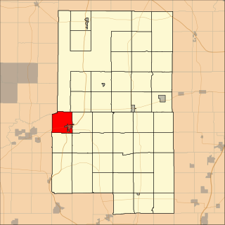
Dean Lake is an unorganized territory in Crow Wing County, Minnesota, United States. The population was 89 at the 2000 census. It is part of the Brainerd Micropolitan Statistical Area. This territory took its name from Dean Lake.

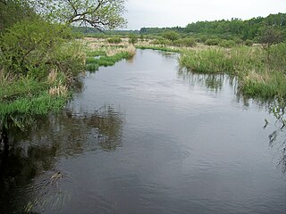
The Crow Wing River is a 113-mile-long (182 km) tributary of the Mississippi River in Minnesota, United States. The river rises at an elevation of about 1391 feet in a chain of 11 lakes in southern Hubbard County, Minnesota, and flows generally south, then east, entering the Mississippi at Crow Wing State Park northwest of Little Falls, Minnesota. Its name is a loose translation from the Ojibwe language Gaagaagiwigwani-ziibi. A wing-shaped island at its mouth accounts for the river's name. Because of its many campsites and its undeveloped shores, the Crow Wing River is considered one of the state's best "wilderness" routes for canoeists; although it is shallow, it is nearly always deep enough for canoeing.

The Arrowhead Region is located in the northeastern part of the U.S. state of Minnesota, so called because of its pointed shape. The predominantly rural region encompasses 10,635.26 square miles (27,545.2 km2) of land area and includes Carlton, Cook, Lake and Saint Louis counties. Its population at the 2000 census was 248,425 residents. Aitkin, Itasca, and Koochiching counties are also sometimes considered as part of the region. This would increase the land area to 18,221.97 square miles (47,194.7 km2) and the population to 322,073 residents.

The Crow River is a tributary of the Mississippi River in south-central Minnesota in the United States. It drains a watershed of 2,756 square miles (7,140 km2).
The Shell River is a 47.8-mile-long (76.9 km) tributary of the Crow Wing River in north-central Minnesota in the United States. Via the Crow Wing River, it is part of the watershed of the Mississippi River, draining a rural region.

The Brainerd Micropolitan Statistical Area, as defined by the United States Census Bureau, is an area consisting of Cass County and [[Crow Wing County, Minnesota|Crow Wing County in Northern Minnesota, anchored by the city of Brainerd. As of February 4, 2011 estimate placed the population at 91,067.
Merrifield is an unincorporated community and census-designated place (CDP) in Lake Edward Township, Crow Wing County, Minnesota, United States, near Brainerd. It is along Crow Wing County Road 3 near County Road 127. Its population was 140 as of the 2010 census.
Lake Hubert is an unincorporated community in Lake Edward Township, Crow Wing County, Minnesota, United States. Lake Hubert is 2 miles (3.2 km) southeast of Nisswa. It is along Crow Wing County Road 13 near County Road 137. Although it is unincorporated, Lake Hubert has the ZIP code 56459.
The Crow Wing Chain of Lakes is a chain of eleven shallow lakes along the Crow Wing River in Hubbard County, Minnesota, approximately 90 miles (140 km) upstream from the Crow Wing's confluence with the Mississippi River. Although connected, there are a few dams between a few of the lakes that are impossible to traverse via motorboats, although they are able to be crossed in canoe.
Lake Mary is a lake in Crow Wing County, in the U.S. state of Minnesota.
Pelican Lake is a lake in Crow Wing County, in the U.S. state of Minnesota.
Ross Lake is a lake in Crow Wing County, in the U.S. state of Minnesota, covering 491 acres.
Bay Lake is an unincorporated community in Bay Lake Township, Crow Wing County, Minnesota, United States, near Deerwood. It is along State Highway 6 near the junction with Crow Wing County Road 14.
