Related Research Articles

Canada has a vast geography that occupies much of the continent of North America, sharing a land border with the contiguous United States to the south and the U.S. state of Alaska to the northwest. Canada stretches from the Atlantic Ocean in the east to the Pacific Ocean in the west; to the north lies the Arctic Ocean. Greenland is to the northeast with a shared border on Hans Island. To the southeast Canada shares a maritime boundary with France's overseas collectivity of Saint Pierre and Miquelon, the last vestige of New France. By total area, Canada is the second-largest country in the world, after Russia. By land area alone, however, Canada ranks fourth, the difference being due to it having the world's largest proportion of fresh water lakes. Of Canada's thirteen provinces and territories, only two are landlocked while the other eleven all directly border one of three oceans.
The Victoria Cross Ranges are a set of mountain ranges in the Canadian Rockies, located to the northwest of Jasper. Of the 19 peaks contained within this range, five are named after Canadian recipients of the Victoria Cross. The area of the ranges is 678 square kilometres (262 sq mi).

Bentley is a town in central, Alberta, Canada within Lacombe County. It is located on Highway 12, approximately 28 km (17 mi) northwest of Red Deer.

The County of Stettler No. 6 is a municipal district in central Alberta, Canada.

Athabasca Pass is a high mountain pass in the Canadian Rockies on the border between Alberta and British Columbia. In fur trade days it connected Jasper House on the Athabasca River with Boat Encampment on the Columbia River.

Division No. 19 is a census division in Alberta, Canada. It is located in the west-central portion of northern Alberta and surrounds the City of Grande Prairie.
Clive is a village in central Alberta, Canada. It is located 15 minutes east of Lacombe and 30 minutes from Red Deer.
Clairmont is a hamlet in northern Alberta, Canada within the County of Grande Prairie No. 1. Previously an incorporated municipality, Clairmont dissolved from village status on January 1, 1946 to become part of the Municipal District of Bear Lake No. 740.
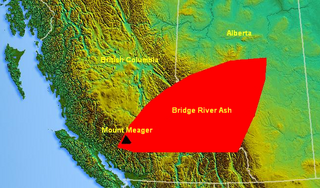
The Bridge River Ash is a large geologically recent volcanic ash deposit that spans from southwestern British Columbia to central Alberta, Canada. The ash consists of dust-sized shards ellipsoidal fragments of pumice. It overlaps the Mount St. Helens Yn Ash and the Mazama Ash which were erupted from Mount St. Helens and Mount Mazama about 3,400 and 6,800 years ago.
Alhambra is a hamlet in Alberta, Canada within Clearwater County. It is located close to the David Thompson Highway, east of Rocky Mountain House.
Belloy is a ghost town in Alberta, Canada within Birch Hills County.
Tonquin Pass, 1948 m (6393 ft), is a mountain pass in the Canadian Rockies, linking Tonquin Valley in Jasper National Park, Alberta, to Mount Robson Provincial Park and adjoining areas of British Columbia. It is at the headwaters of Tonquin Creek, which flows into British Columbia. Located on the interprovincial boundary, it is on the Continental Divide.

Bistcho Lake 213 is an Indian reserve of the Dene Tha' First Nation in Alberta, located within Mackenzie County.

The Jasper Park Information Centre National Historic Site, located in Jasper National Park, Alberta, Canada, is the primary visitor contact centre for visitors to the park. Sited in the Jasper townsite, it was built as the park administration building in 1913-1914, and became the visitor contact centre in 1972. It is located in Athabasca Park, which is not included in the National Historic Site designation.
Goodwin is a locality in Alberta, Canada.
Amber River is a stream in Alberta, Canada.
Cavell Creek is a stream in Alberta, Canada.
Mount Clitheroe is a summit in Alberta, Canada. It takes its name from Clitheroe, in England.
Geikie is a locality in Alberta, Canada.
Mount Henry is a summit in Alberta, Canada.
References
- ↑ "Decoigne". Geographical Names Data Base . Natural Resources Canada.
- ↑ Place-names of Alberta. Ottawa: Geographic Board of Canada. 1928. p. 41.
52°53′02″N118°22′16″W / 52.884°N 118.371°W
| | This Alberta's Rockies location article is a stub. You can help Wikipedia by expanding it. |