Related Research Articles
The Delaware River is a major river in the Mid-Atlantic region of the United States and is the longest free-flowing (undammed) river in the Eastern United States. From the meeting of its branches in Hancock, New York, the river flows for 282 miles (454 km) along the borders of New York, Pennsylvania, New Jersey, and Delaware, before emptying into Delaware Bay.

The Chesapeake & Delaware Canal is a 14-mile (22.5 km)-long, 450-foot (137.2 m)-wide and 35-foot (10.7 m)-deep ship canal that connects the Delaware River with the Chesapeake Bay in the states of Delaware and Maryland in the United States.

The Delaware Valley, sometimes referred to as Greater Philadelphia or the Philadelphia metropolitan area, is a major metropolitan region in the Northeast United States that centers around Philadelphia, the nation's sixth-most populous city, and spans parts of four U.S. states: southeastern Pennsylvania, southern New Jersey, northern Delaware, and the northern Eastern Shore of Maryland. With a core metropolitan statistical area population of 6.288 million residents and a combined statistical area population of 7.366 million as of the 2020 census, the Delaware Valley is the eighth-largest metropolitan region in both the nation and North America, and the 68th-largest metropolitan region in the world.

The Lehigh River is a 109-mile-long (175 km) tributary of the Delaware River in eastern Pennsylvania. The river flows in a generally southward pattern from the Pocono Mountains in Northeastern Pennsylvania through Allentown and much of the Lehigh Valley before joining the Delaware River in Easton.

Tulpehocken Creek is a 39.5-mile-long (63.6 km) tributary of the Schuylkill River in southeastern Pennsylvania in the United States, and during the American Canal Age, once provided nearly half the length of the Union Canal linking the port of Philadelphia, the largest American city and the other communities of Delaware Valley with the Susquehanna basin and the Pennsylvania Canal System connecting the Eastern seaboard to Lake Erie and the new settlements of the Northwest Territory via the Allegheny, Monongahela, and Ohio Rivers at Pittsburgh.

The Delaware and Hudson Canal was the first venture of the Delaware and Hudson Canal Company, which would later build the Delaware and Hudson Railway. Between 1828 and 1899, the canal's barges carried anthracite coal from the mines of northeastern Pennsylvania to the Hudson River and thence to market in New York City.

Blue Mountain, Blue Mountain Ridge, or the Blue Mountains of Pennsylvania is a ridge of the Appalachian Mountains in eastern Pennsylvania. Forming the southern and eastern edge of the Ridge-and-Valley Appalachians physiographic province in Pennsylvania, Blue Mountain extends 150 miles (240 km) from the Delaware Water Gap on the New Jersey border in the east to Big Gap in Franklin County in south-central Pennsylvania at its southwestern end.
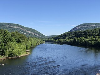
Delaware Water Gap National Recreation Area is a 70,000-acre (28,000 ha) national recreation area administered by the National Park Service in northwest New Jersey and northeast Pennsylvania. It is centered around a 40-mile (64 km) stretch of the Delaware River designated the Middle Delaware National Scenic River. At the area's southern end lays the Delaware Water Gap, a dramatic mountain pass where the river cuts between Blue Mountain and Kittatinny Mountain.
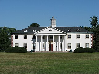
Delaware Valley University (DelVal) is a private university in Doylestown, Pennsylvania. Founded in 1896, it enrolls approximately 1,900 students on its suburban, 570-acre campus. DelVal offers more than 28 undergraduate majors, seven master's programs, a doctoral program, and adult education courses.

The Delaware River–Turnpike Toll Bridge is a four-lane, steel through arch bridge crossing the Delaware River between Burlington Township, Burlington County, New Jersey and Bristol Township, Bucks County, Pennsylvania. As a part of Interstate 95 (I-95), it is a major highway link between Philadelphia and New York City. The bridge also connects the Pennsylvania Turnpike's east-west mainline with the main trunk of the New Jersey Turnpike, via the Pearl Harbor Memorial Turnpike Extension. Tolls are collected only in the west/southbound direction via electronic toll collection.
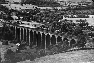
Starrucca Viaduct is a stone arch bridge that spans Starrucca Creek near Lanesboro, Pennsylvania, in the United States. Completed in 1848 at a cost of $320,000, it was at the time the world's largest stone railway viaduct and was thought to be the most expensive railway bridge as well. Still in use, the viaduct is listed on the National Register of Historic Places and is designated as a National Historic Civil Engineering Landmark.

The Delaware Division of the Pennsylvania Canal, more commonly called the Delaware Canal, runs for 60 miles (97 km) parallel to the right bank of the Delaware River from the entry locks near the mouth of the Lehigh River and terminal end of the Lehigh Canal at Easton south to Bristol. At Easton, which today is the home of The National Canal Museum, the Delaware Canal also connected with the Morris Canal built to carry anthracite coal to energy-starved New Jersey industries.
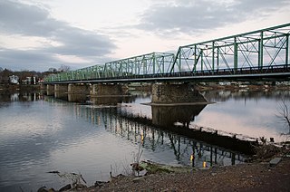
The New Hope–Lambertville Bridge, officially called the New Hope–Lambertville Toll Supported Bridge, is a six-span, 1,053-foot (321 m)-long bridge spanning the Delaware River that connects Lambertville, New Jersey and New Hope, Pennsylvania. The current steel truss bridge was constructed in 1904 at a cost of $63,818.81. It is owned and maintained as a toll-free bridge by the Delaware River Joint Toll Bridge Commission.

Pennsylvania Route 652 is a 10.559-mile-long (16.993 km) east–west state highway located in the northeast Pennsylvania county of Wayne. The western terminus of the route is at U.S. Route 6 in the Texas Township community of Indian Orchard. The highways heads to the northeast, and reaches the eastern terminus at the New York-Pennsylvania border in Damascus Township, where PA 652 crosses the Narrowsburg–Darbytown Bridge over the Delaware River and into New York, continuing as New York State Route 52 and County Route 24 in Sullivan County.
The National Council of Structural Engineers Associations (NCSEA) is a professional association in the United States, with member organizations in 44 states. NCSEA was established in 1993. As of 2003, NCSEA represented 12,000 individual engineers, who are members of local state associations.

Lamokin Street is a former regional rail station that was located on the SEPTA Regional Rail Wilmington/Newark Line at Lamokin Street in Chester, Pennsylvania. Until 1972, it was the junction for the Chester Creek Branch, controlled by nearby Lamokin Tower. The branch line was operated by the Pennsylvania Railroad and later Penn Central, until service ended in 1972 due to damage caused by Hurricane Agnes.

The Walt Whitman Bridge is a single-level suspension bridge spanning the Delaware River from Philadelphia in the west to Gloucester City in Camden County, New Jersey in the east. The bridge is named after American poet and essayist Walt Whitman, who resided in nearby Camden toward the end of his life.

The Minisink or Minisink Valley is a loosely defined geographic region of the Upper Delaware River valley in northwestern New Jersey, northeastern Pennsylvania and New York.

Wallpack Ridge is a mountain located in the Ridge and Valley Appalachians physiographic province in Sussex County in northwestern New Jersey. Oriented northeast to southwest, Wallpack Ridge spans 25 miles (40 km) from Montague Township south of Port Jervis, New York to the Walpack Bend in the Delaware River near Flatbrookville in Walpack Township. It is a narrow ridge ranging between 0.67 miles (1.08 km) to 1.7 miles (2.7 km) in width, and its highest elevation reaches 928 feet (283 m) above sea level. The ridge separates the Wallpack Valley from the valley of the Delaware River, and contains the watershed of the Flat Brook and its main tributaries Big Flat Brook and Little Flat Brook.
Delaware Valley is the valley of the Delaware River in the northeastern United States. By extension, the toponym is commonly applied to the Philadelphia metropolitan area, which straddles the Lower Delaware Valley.
References
- ↑ Delaware Valley Association of Structural Engineers. "About DVASE" . Retrieved 2012-10-26.