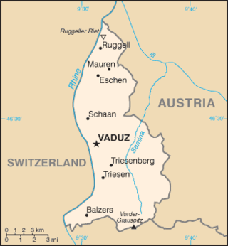
The principality of Liechtenstein encompasses most of the eastern half of the Rhine Valley, wedged between Austria and Switzerland. The majority of the country's population is found in the western half along the Rhine River. Along with Uzbekistan, Liechtenstein is one of only two doubly landlocked countries in the world.

The Four Corners Monument marks the quadripoint in the Southwestern United States where the states of Arizona, Colorado, New Mexico, and Utah meet. It is the only point in the United States shared by four states, leading to the area being named the Four Corners region. The monument also marks the boundary between two semi-autonomous Native American governments, the Navajo Nation, which maintains the monument as a tourist attraction, and the Ute Mountain Ute Tribe Reservation.

Austria is a predominantly mountainous country in Central Europe, approximately between Germany, Italy and Hungary. It has a total area of 83,871 square kilometres (32,383 sq mi).

The Mason–Dixon line is a demarcation line separating four U.S. states, Pennsylvania, Maryland, Delaware and West Virginia. It was surveyed between 1763 and 1767 by Charles Mason and Jeremiah Dixon as part of the resolution of a border dispute involving Maryland, Pennsylvania, and Delaware in the colonial United States.
A triple border, tripoint, trijunction, triple point, or tri-border area is a geographical point at which the boundaries of three countries or subnational entities meet. There are 175 international tripoints as of 2020. Nearly half are situated in rivers, lakes or seas. On dry land, the exact tripoints may be indicated by markers or pillars, and occasionally by larger monuments.
Fieberbrunn is a market town in the Austrian state of Tyrol in the Kitzbühel district. It is located at 47°28′N12°33′E, in the Kitzbühel Alps. Fieberbrunn is the most populous municipality in the Pillerseetal valley.
Southern Germany is a region of Germany that included the areas in which Upper German dialects are spoken, which includes the stem duchies of Bavaria and Swabia in present-day Bavaria, Baden-Württemberg, and the southern portion of Hesse and Rhineland-Palatinate that were part of the Duchy of Franconia.
A quadripoint is a point on Earth where four distinct political territories meet. The territories can be of different types, such as national and provincial. In North America, several such places are commonly known as Four Corners. Several examples exist throughout the world that use other names.

A boundary marker, border marker, boundary stone, or border stone is a robust physical marker that identifies the start of a land boundary or the change in a boundary, especially a change in direction of a boundary. There are several other types of named border markers, known as boundary trees, pillars, monuments, obelisks, and corners. Border markers can also be markers through which a border line runs in a straight line to determine that border. They can also be the markers from which a border marker has been fixed.

The Chiemgau Alps are a mountain range in the Northern Limestone Alps and belong to the Eastern Alps. They are crossed by the Austria–Germany border: their major part is situated in Bavaria, Germany, and only a small section crosses the Austrian border into the states of Salzburg and Tirol. They reach their highest elevation in the Sonntagshorn, a peak straddling the German-Austrian border.

The Wetterstein mountains, colloquially called Wetterstein, is a mountain group in the Northern Limestone Alps within the Eastern Alps, crossing the Austria–Germany border. It is a comparatively compact range located between Garmisch-Partenkirchen, Mittenwald, Seefeld in Tirol and Ehrwald along the border between Germany (Bavaria) and Austria (Tyrol). Zugspitze, the highest peak is at the same time the highest mountain in Germany.

The Blauberge or Blauberg are a mountain range in the Bavarian Prealps on the border between the states of Bavaria in Germany and Tyrol in Austria. Its highest summit is the Halserspitze, or Halserspitz at 1,862 m.

Schinder is a mountain on the border of Bavaria, Germany and Tyrol, Austria. There are two summits, one called Austrian Schinder or Trausnitzberg, and the other slightly lower one called Bavarian Schinder. The former sits right on the border of Bavaria and Tyrol, whereas the latter is situated wholly in Bavaria.

Sorgschrofen is a 1,635-metre-tall (5,364 ft) mountain in the Allgäu Alps of Bavaria, Germany. A lower summit of Sorgschrofen is the 1,613-metre-tall (5,292 ft) Zinken. There is a summit cross on both Sorgschrofen and Zinken.

The geographic center of the United States is a point approximately 20 mi (32 km) north of Belle Fourche, South Dakota at 44°58′2.07622″N103°46′17.60283″W. It has been regarded as such by the United States Coast and Geodetic Survey and the U.S. National Geodetic Survey (NGS) since the additions of Alaska and Hawaii to the United States in 1959.

The Bavarian Zugspitze Railway is one of four rack railways still working in Germany, along with the Wendelstein Railway, the Drachenfels Railway and the Stuttgart Rack Railway. The metre gauge line runs from Garmisch in the centre of Garmisch-Partenkirchen to the Zugspitzplatt, approximately 300 metres below Zugspitze, the highest mountain in Germany. The line culminates at 2,650 metres above sea level, which makes it the highest railway in Germany and the third highest in Europe. It is also the railway in Europe with the biggest height difference: 1,945 metres, the lower half being open-air and the upper half being underground.
The Tannheim Mountains are a sub-group of the Allgäu Alps in the Bavarian-Tyrolean border region. Their name is derived from the village of Tannheim in the Tannheim Valley in the Austrian state of Tyrol.
The Randen is a small mountain range located between the Jura and the Swabian Jura, north of the Rhine. Predominantly located in the Swiss canton of Schaffhausen, they culminate in the German state of Baden-Württemberg. The Randen, which belong to the Table Jura (Tafeljura), are situated north of Schaffhausen and south of Blumberg.

The Simonyspitzen are two mountain summits in the Venediger Group of the Austrian Central Alps. They lie within the High Tauern National Park on the border between the Austrian states of East Tyrol and Salzburg.

The border between the modern states of Austria and Germany has a length of 815.9 km (507.0 mi), or 815.0 km (506.4 mi) respectively. It is the longest international border of Austria and the second longest border of Germany with another country.

 Boundary marker on the Demeljoch, at the border between Austria and Germany. The "Ö" stands for "Österreich", i.e. Austria in German.
 Same boundary marker on the other side. The "D" stands for "Deutschland", i.e. Germany in German.
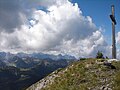 Summit cross on the Demeljoch, with, in the background, the view towards the west.
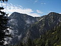 Demeljoch (left) and Dürnbergjoch (right) from the north.


