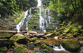
Franklin-Gordon Wild Rivers is a national park in Tasmania, 117 km west of Hobart. It is named after the two main river systems lying within the bounds of the park - the Franklin River and the Gordon River.

Cradle Mountain is a locality and mountain in the Central Highlands region of the Australian state of Tasmania. The mountain is situated in the Cradle Mountain-Lake St Clair National Park.

Lake St Clair or leeawulenna is a natural freshwater lake located in the Central Highlands area of Tasmania, Australia. The lake forms the southern end of the Cradle Mountain-Lake St Clair National Park. It has an area of approximately 45 square kilometres (17 sq mi), and a maximum depth of 215 metres (705 ft), making it Australia's deepest lake.
Kathleen Island is a steeply cliffed island that lies within Port Davey, an oceanic inlet, located in the south west region of Tasmania, Australia. The island has an area of approximately 11.35 hectares and is contained with the Southwest National Park, part of the Tasmanian Wilderness World Heritage Site and the Port Davey/Bathurst Harbour Marine Nature Reserve.

Tasmania Parks and Wildlife Service is the government body responsible for protected areas of Tasmania on public land, such as national parks, historic sites and regional reserves. Historically it has also had responsibility for managing wildlife, including game.

The Tasmanian Museum and Art Gallery (TMAG) is a museum located in Hobart, Tasmania. The museum was established in 1846, by the Royal Society of Tasmania, the oldest Royal Society outside England. The TMAG receives 400,000 visitors annually.

The Tasmanian Department of Natural Resources and Environment (NRE) is the government department of the Tasmanian Government responsible for supporting primary industry development, the protection of Tasmania's natural environment, effective land and water management and the protection of Tasmania's relative disease and pest free status. NRE's responsibilities also include maintaining the security of land tenure, administration of much of the state's Crown lands and delivery of government services through Service Tasmania.

The Judgement Rocks, part of the Kent Group, is a small unpopulated 0.39-hectare (0.96-acre) granite islet and some associated bare rocks, located in the Bass Strait, lying off the north-east coast of Tasmania, between the Furneaux Group and Wilsons Promontory in Victoria, Australia. The islet and associated rocks are contained within the Kent Group National Park.

Dover Island, the third largest island in the Kent Group, is a densely vegetated and unpopulated 295-hectare (730-acre) granite island with steep slopes, located in the Bass Strait, lying off the north-east coast of Tasmania, between the Furneaux Group and Wilsons Promontory in Victoria, Australia.
The Fitzroy Islands comprise a group of four rocky islets that lie within the upper reaches of Payne Bay in Port Davey, an oceanic inlet, located in the south west region of Tasmania, Australia. The islands have a combined area of approximately 0.18 hectares and are contained with the Southwest National Park, part of the Tasmanian Wilderness World Heritage Site and the Port Davey/Bathurst Harbour Marine Nature Reserve.
Munday Island is a small island that lies between Port Davey, an oceanic inlet, and Bathurst Channel, located in the south west region of Tasmania, Australia. The island is contained with the Southwest National Park, part of the Tasmanian Wilderness World Heritage Site and the Port Davey/Bathurst Harbour Marine Nature Reserve.

North West Tasmania is one of the regions of Tasmania in Australia. The region comprises the whole of the north west, including the North West Coast and the northern reaches of the West Coast. It is usually accepted as extending as far south as the Pieman River and including the Savage River National Park within the Tarkine region.
The Tasmanian Department of State Growth is the Tasmanian Government department with responsibility for driving state growth and to implement the government's long-term plan for creating jobs, growth, and opportunities for all Tasmanians, in Australia.

Isle of the Dead is an island, about 1 hectare in area, adjacent to Port Arthur, Tasmania, Australia. It is historically significant since it retains an Aboriginal coastal shell midden, one of the first recorded sea-level benchmarks, and one of the few preserved Australian convict-period burial grounds. The Isle of the Dead occupies part of the Port Arthur Historic Site, is part of Australian Convict Sites and is listed as a World Heritage Property because it represents convictism in the era of British colonisation.

The Shot Tower at Taroona is a heritage listed historic building between Hobart and Kingston, Tasmania. It was the tallest building in Australia for four years (1870-1875), and the tallest structure in Tasmania until it was superseded by the Mount Wellington broadcast tower in 1960. The Taroona Shot Tower is believed to be the tallest circular sandstone tower in the world.
The Tasmanian Environmental Protection Authority(EPA) is an agency of the Tasmanian government.
Tourism Tasmania is the authority of the Government of Tasmania for dealing with tourism.


