Derrinallum P12 College is a co-educational state P-12 school in Derrinallum, Victoria. The college has approximately 85 students from Prep to Year 12. Derrinallum P12 College is set in 5 hectares (12.4 acres) of land, near the Hamilton Highway.
The College facilities feature a library/resource centre and computer room, music room, student welfare room, technical workshop, indoor sports centre, specialist science rooms and technology studies areas for textiles, home economics and woodwork, as well as a centrally located administration block and canteen. The grounds encompass gardens, two ovals, athletics track, hockey field, two cricket pitches, cricket nets, basketball, netball and tennis courts, modern playground, two bus shelters and a bicycle path to the township of Derrinallum.
In 2006 Derrinallum P12 College received the 37th highest ENTER score average in Victoria.
Xavier College is a Roman Catholic, day and boarding school predominantly for boys, founded in 1872 by the Society of Jesus, with its main campus located in Kew, an eastern suburb of Melbourne, Victoria, Australia. Classes started in 1878.
Maryborough is a town in Victoria, Australia, on the Pyrenees Highway, 58 kilometres (36 mi) north of Ballarat and 168 kilometres (104 mi) northwest of Melbourne, in the Shire of Central Goldfields. At the 2016 census, it had a population of 7,921.
Whitefriars College is a Roman Catholic Independent school for boys located in the Melbourne suburb of Donvale. Established in 1961, the College reflects the tradition of the Carmelites, and is recognised for its uniform's brown blazer with the College Crest appearing on the breast pocket. The College has been a member of the Associated Catholic Colleges since 1999. The College was one of the first schools in Victoria to implement a notebook-computer program, which has now transitioned to a notebook-tablet program, in which every student is provided with a notebook-tablet. Its student population makes it the second largest independent school and educator of boys in the Municipality of Manningham.
Derrinallum is a town in Victoria, Australia, located on the Hamilton Highway, in the Corangamite Shire. The town is the centre for the surrounding farming community and lies at the foot of Mount Elephant. Mount Elephant is a 380 m-high conical breached scoria cone formed by an extinct volcano.
McKinnon Secondary College is a public secondary school located in the Melbourne suburb of McKinnon. The school was ranked 62nd in Victoria in terms of VCE median study score in 2012. Recently, The school has opened a second campus dubbed the east campus by students. McKinnon is known for its large music faculty.
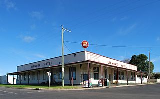
Lismore is a town in Victoria, Australia, located on the Hamilton Highway 170 kilometres (106 mi) west of Melbourne. It is part of the Corangamite Shire local government area. At the 2016 census, Lismore had a population of 420.
Lauriston Girls' School is an independent, non-denominational, day school for girls, located in Armadale, an inner south-eastern suburb of Melbourne, Victoria, Australia.
Toorak College is an independent, inter-denominational, day and boarding school for girls years 5 - 12 and co-educational from pre school to year four. The school is located on the Mornington Peninsula, above Port Phillip Bay in Mount Eliza, a town approximately forty kilometres south of Melbourne, Victoria, Australia.
Parade College is an independent Catholic secondary school for boys, located across two campuses in the northern suburbs of Melbourne, Victoria, Australia; one at Bundoora; the other, 8 kilometres (5.0 mi) away, at Preston. The school was founded by the Congregation of Christian Brothers in January 1871 and is a member of Edmund Rice Education Australia.
Brentwood Secondary College is a co-educational, public high school, located in Glen Waverley, Victoria, Australia.
Loreto Mandeville Hall Toorak is an independent Roman Catholic single-sex primary and secondary day school for girls, located in Toorak, a suburb of Melbourne, Victoria, Australia. It is one of many Loreto schools around the world, established by the Loreto Sisters founded some 400 years ago by Mary Ward.
Ballarat Clarendon College is an independent, co-educational, day and boarding school, located in Ballarat, Victoria, Australia.
The Shire of Tullaroop was a local government area about 170 kilometres (106 mi) northwest of Melbourne, the state capital of Victoria, Australia, surrounding the regional centre of Maryborough. The shire covered an area of 637.63 square kilometres (246.2 sq mi), and existed from 1861 until 1995. Maryborough itself was managed by a separate entity, ultimately known as the City of Maryborough. After a large-scale statewide amalgamation program by the Victorian Government in 1994, they were united under the Shire of Central Goldfields.
The City of Maryborough was a local government area about 170 kilometres (106 mi) northwest of Melbourne, the state capital of Victoria, Australia, and the governing body for the regional centre of Maryborough. The City covered an area of 23.32 square kilometres (9.0 sq mi), and existed from 1857 until 1995. The City of Maryborough was surrounded by the Shire of Tullaroop, which was united with Maryborough under the Shire of Central Goldfields as part of a large-scale statewide amalgamation program by the Victorian Government in 1994-95.
P12 or P–12 may refer to:
The Shire of Hampden was a local government area about 200 kilometres (124 mi) west-southwest of Melbourne, the state capital of Victoria, Australia. The shire covered an area of 2,620.91 square kilometres (1,011.9 sq mi), and existed from 1857 until 1994.
The Shire of Grenville was a local government area southwest of the regional city of Ballarat, Victoria, Australia. The shire covered an area of 845 square kilometres (326.3 sq mi), and existed from 1861 until 1994.
Ballarat Christian College is an independent, co-educational P-12 day school located in Ballarat, Victoria, Australia. Ballarat Christian College provides education for children in a Christian environment, in the evangelical Protestant tradition.
Beaufort Secondary College is a state secondary college located in the town of Beaufort in Victoria, Australia which is located on the Western Highway midway between Ararat and Ballarat, in the Pyrenees Shire local government area.
Eastern Oval is a cricket ground in the city of Ballarat, Victoria, Australia.
This page is based on this Wikipedia article Text is available under the CC BY-SA 4.0 license; additional terms may apply. Images, videos and audio are available under their respective licenses.