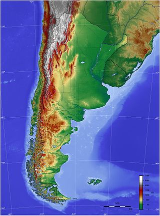
The geography of Argentina is heavily diverse, consisting of the Andes Mountains, pampas, and various rivers and lakes. Bordered by the Andes in the west and the South Atlantic Ocean to the east, its neighbouring countries are Chile to the west, Bolivia and Paraguay to the north, and Brazil and Uruguay to the northeast.
Mendoza, officially Province of Mendoza, is a province of Argentina, in the western central part of the country in the Cuyo region. It borders San Juan to the north, La Pampa and Neuquén to the south, San Luis to the east, and the republic of Chile to the west; the international limit is marked by the Andes mountain range. Its capital city is the homonymous city of Mendoza.

San Juan Province is a province of Argentina, located in the western part of the country. Neighbouring provinces are, moving clockwise from the north, La Rioja, San Luis and Mendoza. It borders with Chile to the west.

Mendoza, officially the City of Mendoza, is the capital of the province of Mendoza in Argentina. It is located in the northern-central part of the province, in a region of foothills and high plains, on the eastern side of the Andes. As of the 2010 census [INDEC], Mendoza had a population of 115,041 with a metropolitan population of 1,055,679, making Greater Mendoza the fourth largest census metropolitan area in the country.

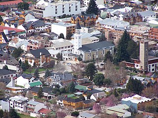
San Carlos de Bariloche, usually known as Bariloche, is a city in the province of Río Negro, Argentina, situated in the foothills of the Andes on the southern shores of Nahuel Huapi Lake. It is located within the Nahuel Huapi National Park. After development of extensive public works and Alpine-styled architecture, the city emerged in the 1930s and 1940s as a major tourism centre with skiing, trekking and mountaineering facilities. In addition, it has numerous restaurants, cafés, and chocolate shops. The city had a permanent population of 108,205 according to the 2010 census. According to the latest statistics from 2015, the population is around 122,700, and a projection for 2020 estimates 135,704.

Cuyo is the wine-producing, mountainous region of central-west Argentina. Historically it comprised the provinces of San Juan, San Luis and Mendoza. The modern New Cuyo includes both Cuyo proper and the province of La Rioja. New Cuyo is a political and economic macroregion, but culturally La Rioja is part of the North-West rather than of Cuyo.
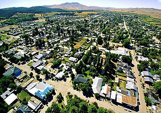
San Martín de los Andes is a city in the south-west of the province of Neuquén, Argentina, serving as the administration centre of the Lácar Department. Lying at the foot of the Andes, on the Lácar lake, it is considered one of the main tourism destinations in the province. The National Route 40 runs to the city, connecting it with important touristic points in the south of the province, such as Lanín and Nahuel Huapí national parks.

The Chilean War of Independence was a military and political event that allowed the emancipation of Chile from the Spanish Monarchy, ending the colonial period and initiating the formation of an independent republic.

The Crossing of the Andes was one of the most important feats in the Argentine and Chilean wars of independence. A combined army of Argentine soldiers and Chilean exiles crossed the Andes mountains, which separate Argentina from Chile, to invade Chile, leading to its liberation from Spanish rule.

Francisco Casimiro Marcó del Pont y Ángel was a Spanish soldier and the last Governor of Chile. He was one of the main figures of the Chilean independence process, being the final Spaniard to rule as Royal Governor of Chile from 1815 to 1817, when he was deposed and captured by the patriot forces after the Battle of Chacabuco.
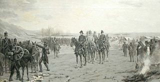
The Army of the Andes was a military force created by the United Provinces of the Río de la Plata (Argentina) and assembled by General José de San Martín as part of his campaign to liberate Chile from the Spanish Empire. In 1817, it crossed the Andes Mountains from the Argentine province of Cuyo and succeeded in its objective by driving the Spanish out of Chile.

El Camino Real de Tierra Adentro, also known as the Silver Route, was a Spanish 2,560-kilometre-long (1,590 mi) road between Mexico City and San Juan Pueblo, New Mexico, that was used from 1598 to 1882. It was the northernmost of the four major "royal roads" that linked Mexico City to its major tributaries during and after the Spanish colonial era.

The Diamante River is a river in the Argentine province of Mendoza. It is born from glaciers on the Maipo, a volcano in the Andes range in the Argentine–Chilean border, and flows east until emptying in the Desaguadero River. Its drainage basin covers an area of 2,750 square kilometres (1,060 sq mi) in the central region of Mendoza.
La Paz is a department in the province of Mendoza, Argentina, headquartered in the town of the same name, located 145 km (90 mi) from the provincial capital. It limits to the north with the Lavalle department, to the south with San Rafael, to the west with Santa Rosa and to the east with the province of San Luis.
Junín de los Andes is a first category municipality and administrative center of the Huiliches Department in the province of Neuquén, Argentina. It is located in the south of the province, by the Chimehuin River, on National Route 40, about 35 km (22 mi) north of San Martín de los Andes and 17 km (11 mi) from the Chapelco Airport, which services the area.

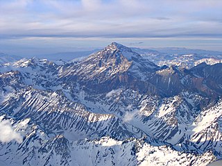
Volcán Tupungatito is the northernmost historically active stratovolcano of the southern Andes. Part of the Chilean Andes' volcanic segment, it is the northernmost member of the Southern Volcanic Zone (SVZ), which is one of several distinct volcanic belts in the Andes. Over 70 Pleistocene or Holocene age volcanoes make up this volcanic belt, which on average has one eruption per year.
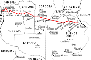
National Route 7 is a road in Argentina. It crosses the country from east to west, from the capital to the border with Chile, thus linking the Atlantic coast with the Andes, crossing the provinces of Buenos Aires, Santa Fe, Córdoba, San Luis and Mendoza. It has a total length of 1,224 km (761 mi), of which 367 km (228 mi) (30%) are freeways.

The Sierra de las Quijadas National Park is a national park located in the northwestern part of the Argentine province of San Luis. It was established on December 10, 1991, to protect the natural features, representative of the Semiarid Chaco and the High Monte ecoregions.
El Camino Viejo a Los Ángeles, also known as El Camino Viejo and the Old Los Angeles Trail, was the oldest north-south trail in the interior of Spanish colonial Las Californias (1769–1822) and Mexican Alta California (1822–1848), present day California. It became a well established inland route, and an alternative to the coastal El Camino Real trail used since the 1770s in the period.

