
Transportation planning is the process of defining future policies, goals, investments, and designs to prepare for future needs to move people and goods to destinations. As practiced today, it is a collaborative process that incorporates the input of many stakeholders including various government agencies, the public and private businesses. Transportation planners apply a multi-modal and/or comprehensive approach to analyzing the wide range of alternatives and impacts on the transportation system to influence beneficial outcomes.

The Thames Gateway is an area of land stretching 70 kilometres (43 mi) east from inner east London on both sides of the River Thames and the Thames Estuary. The area, which includes much brownfield land was designated during the early years of the Blair ministry a national priority for urban regeneration, taking advantage of the development opportunities realised by the completion of the High Speed 1. First named by the UK government, which is unusual in the United Kingdom, uptake of and appreciation of the term varies, with many people preferring the traditional term, the Thames Estuary.

The Stonehenge road tunnel is a planned tunnel in Wiltshire, England, drawn up by Highways England to upgrade the A303 road. It would move the A303 into a tunnel under the Stonehenge World Heritage Site, completing the removal of traffic begun with the closure of the A344 road. The wider project was designed to improve the landscape around the monument and to improve safety on the A303, and was part of proposals to change the site in other ways including moving the visitors centre. The project is expected to cost £1.7 billion.

Merseytram was a proposed light rail system for Merseyside, England. Originally proposed in 2001, forming part of the Merseyside Local Transport Plan, it was to consist of three lines, connecting the Metropolitan Borough of Knowsley with central Liverpool. The project was postponed due to funding problems before eventually being formally closed down by Merseytravel in October 2013.
Town and country planning in the United Kingdom is the part of English land law which concerns land use planning. Its goal is to ensure sustainable economic development and a better environment. Each country of the United Kingdom has its own planning system that is responsible for town and country planning devolved to the Northern Ireland Assembly, the Scottish Parliament and the Senedd.
Regional spatial strategies (RSS) provided regional level planning frameworks for the regions of England outside London. They were introduced in 2004. Their revocation was announced by the new Conservative/Liberal Democrat government on 6 July 2010.
In the United Kingdom, Planning Policy Guidance Notes (PPG) were statements of the Government's national policy and principles towards certain aspects of the town planning framework.

The Town and Country Planning Act 1990 is an act of the United Kingdom Parliament regulating the development of land in England and Wales. It is a central part of English land law in that it concerns town and country planning in the United Kingdom. Repealed in parts by the Planning and Compensation Act 1991, it is now also complemented by the Planning and Compulsory Purchase Act 2004.
Development Management, formerly known as planning control, or development control, is the element of the United Kingdom's system of town and country planning through which local government or the Secretary of State, regulates land use and new building, i.e. development. It relies on a "plan-led system" whereby development plans are produced, involving various stages of public consultation prior to being adopted. Subsequently, development that requires planning permission, which is granted or refused with reference to the development plan as the starting point, then other material considerations are taken into account. The term "development management" is often abbreviated to DM.
Structure planning is a type of spatial planning and is part of urban planning practice in the United Kingdom and Western Australia. A structure plan in any jurisdiction will usually consist of a written component, supported by maps, photographs, sketches, tables and diagrams and a 'plan' component consisting of one or more plans illustrating land use and infrastructure proposals for the area being planned.

The Gateway Plus project was a redevelopment scheme that regenerated Birmingham New Street railway station and the Pallasades Shopping Centre above it in Birmingham, England. It was completed in September 2015. The project aimed to enhance the station to cope with increased passenger numbers as well as expected future growth in traffic, but did not alter the train capacity of the station. In 2008, the station handled passenger numbers far in excess of the capacity of its existing design. The current station and Pallasades Shopping Centre were completed in 1967 and became the subject of criticism for the congestion of the station and shabbiness of the shopping centre and parts of the station. It is part of the Big City Plan.
Sheffield Retail Quarter is a retail development under construction in Sheffield city centre, England between the Devonshire Quarter and The Moor Gateway. The project was previously given the marketing name Sevenstone, prior to Hammerson, the developer, being dropped from the project in July 2013 with Sheffield City Council seeking new developers.
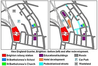
The New England Quarter is a mixed-use development in the city of Brighton and Hove, England. It was built between 2004 and 2008 on the largest brownfield site in the city, adjacent to Brighton railway station. Most parts of the scheme have been finished, but other sections are still being built and one major aspect of the original plan was refused planning permission.

The Northumberland Development Project is a mixed-use development project that centres around the new Tottenham Hotspur Stadium which replaced White Hart Lane as the home ground of Tottenham Hotspur. On opening in April 2019, the stadium had a capacity for 62,062 spectators, later increased to 62,303, and was designed to host football as well as NFL games. The development plans also include 585 new homes, a 180-room hotel, a local community health centre, the Tottenham Experience, a Spurs museum and club shop, an extreme sports facility, as well as the Lilywhite House, which contains a Sainsbury's supermarket, a sixth form college and the club's headquarters.
The expansion of Heathrow Airport is a series of proposals to add to the runways at London's busiest airport beyond its two long runways which are, since the 1990s, intensively used to serve four terminals and a large cargo operation. The plans are those presented by Heathrow Airport Holdings and an independent proposal by Heathrow Hub with the main object of increasing capacity.

Gloucester Services is a pair of Motorway Service Areas (MSA) serving the northbound and southbound carriageways of the M5 between Junction 11A and Junction 12, near Whaddon, Gloucester. It specialises in selling artisanal food, and does not offer outlets for popular chain food brands.
Building for Life, Building for Life 12, Adeliladu am Oes 12 Cymru and Building for a Healthy Life are design tools for improving the quality of new homes and neighbourhoods used across England and Wales. The current version in use in England is Building for a Healthy Life.
Brent Cross Cricklewood is a planned new town centre development in Hendon and Cricklewood, London, United Kingdom. The development is planned to cost around £4.5 billion to construct and will include 7,500 homes, 4,000,000 sq ft (370,000 m2) of offices, four parks, transport improvements and a 592,000 sq ft (55,000 m2) extension of Brent Cross Shopping Centre. The developers of the scheme are Hammerson and Standard Life.

An isochrone map in geography and urban planning is a map that depicts the area accessible from a point within a certain time threshold. An isochrone is defined as "a line drawn on a map connecting points at which something occurs or arrives at the same time". In hydrology and transportation planning isochrone maps are commonly used to depict areas of equal travel time. The term is also used in cardiology as a tool to visually detect abnormalities using body surface distribution.

The National Planning Policy Framework (NPPF) is a land-use planning policy in the United Kingdom. It was originally published by the UK's Department of Communities and Local Government in March 2012, consolidating over two dozen previously issued documents called Planning Policy Statements (PPS) and Planning Policy Guidance Notes (PPG) for use in England. It has since been revised in 2018 and 2019.