
Karaikudi is a municipality in Sivaganga district in the Indian state of Tamil Nadu. It is the 20th largest urban agglomeration of Tamil Nadu based on 2011 census data. It is part of the area commonly referred to as "Chettinad" and has been declared a heritage town by the Government of Tamil Nadu, on account of the palatial houses built with limestone called karai veedu.
Ramanathapuram, also known as Ramnad, is a town and a municipality in Ramanathapuram district in the Indian state of Tamil Nadu. It is the administrative headquarters of Ramanathapuram district and the second largest town in Ramanathapuram district. As of 2011 census, the town had a population of 61,440.Density of population: 320 people per square kilometer; Literacy Rate: 81.48% - Male: 87.89%, Female: 74.93%; Male Female Ratio: 1000:977.Ramanathapuram is the top producer of chilli pepper in Tamil Nadu. It is connected to other cities by NH-49.
Pudukkottai District is a district of Tamil Nadu state in southern India. The city of Pudukkottai is the district headquarters. It is also known colloquially as Pudhugai. Pudukkottai district is one of the least urbanised district in Tamil Nadu.

Thiruppuvanam is a panchayat town, in Manamadurai Division, Sivaganga district in the Indian state of Tamil Nadu. The town is famous for Sri Pushpavaneswarar temple, which is one of the Padal Petra Shiva sthalams.
Monnani is a village in Sivagangai District in the Indian State of Tamil Nadu. It has a population of over 100.
Gmina Szczutowo is a rural gmina in Sierpc County, Masovian Voivodeship, in east-central Poland. Its seat is the village of Szczutowo, which lies approximately 11 kilometres north-west of Sierpc and 125 km north-west of Warsaw.
The estate of Sivaganga, as per British records also known as Kingdom of the Lesser Marava, was a permanently settled zamindari estate in the Ramnad sub-division of Madura district, Madras Presidency, British India. Along the estate of Ramnad, it formed one of the two zamindari estates of Ramnad subdivision.
Ilaiyangudi is a state assembly constituency in Sivaganga district in Tamil Nadu.
Karaikudi is a state assembly constituency in Sivaganga district in Tamil Nadu.
Manamadurai is the 187th state assembly constituency in Tamil Nadu. It is a Scheduled Caste reserved constituency located in Sivaganga district. It is a component of Sivaganga Lok sabha constituency.
Devakottai taluk is a taluk of Sivagangai district of the Indian state of Tamil Nadu. The headquarters of the taluk is the town of Devakottai
Palli Chandai is a small village near Keeladi, on the border of Madurai and Sivaganga districts. The grave of Hazrat Saalaar Shah Shaheed who was a soldier in the army of Qutb Sulthan Syed Ibrahim Shaheed of Erwadi and Hazrat Sulthan Sikandhar Badusha of Thiruparankundram in Madurai is located here.The anniversary Urus festival of this dargah is commemorated in the Islamic month of Safar. The mosque and dargah are renovated by local Muslims.
Kandaramanickam is a village in Sivaganga district, in the state of Tamil Nadu, India.
Muraiyur is a village in the Taluk of Singampunari in the district of Sivaganga in the Indian state of Tamil Nadu.In Muraiyur,Meenakshi Chokanathar Temple is one of Most Famous Temple.Everyone celebrates it by offering coconuts for archana's.
Singampunari is a revenue block in the Sivaganga district of Tamil Nadu, India. It has a total of 30 panchayat villages.
Sarugani is a river flowing in the Sivagangai district of the Indian state of Tamil Nadu.
Kallal is a village in Sivaganga District of Tamil Nadu in India. Kallal block Panchayat is one of the 12 block Panchayat coming under Sivaganga District administration of Tamil Nadu state in India. Kallal is well connected by both Road transport and Rail network. Both state owned TNSTC and Private Omni Bus services are operated from Kallal to different parts of Tamil Nadu state.
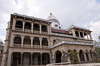
Sivaganga Palace is a palace in Sivaganga district, Tamil Nadu, southern India, about 40 kilometres (25 mi) from Madurai. It is an old royal palace, with many historical connections. The palace was used as residence by queens Velu Nachiyar (1780–90), Vellacci Nachiyar (1790–93) and Rani Kaathama Nachiar (1864–77). No remains of the original Sivaganga Palace exist, but a new palace, known as "Gowri Vilasam", was built by Padamathur Gowry Vallabha Thevar (1801-1829) in the year 19th century. A heritage site of Chettinad, it was the property of Rani Velu Nachiar.
Vetriyur is a village in Sivaganga district in the Indian state of Tamil Nadu.


