
Chikmagalur, officially Chikkamagaluru is an administrative district in the Malnad subregion of Karnataka, India. Coffee was first cultivated in India in Chikmagalur. The hills of Chikmagalur are parts of the Western Ghats and the source of Tunga and Bhadra rivers. Mullayanagiri, the highest peak in Karnataka is located in the district. The area is well known for the Sringeri Mutt that houses the Dakshina Peeta established by Adi Shankaracharya.
Kemmannugundi is a hill station in Tarikere taluk of Chikkamagaluru district in the state of Karnataka, India. It is at the elevation of 1434m above sea level, with its peak at 1863m. This was the summer retreat of Krishnaraja Wodeyar IV, and as a mark of respect to the king, it is also known as Sri Krishnarajendra Hill Station. The station is ringed by the Baba Budan Giri Range, with cascades, mountain streams, and lush vegetation. Kemmangundi has ornamental gardens and mountains and valleys views.

Belur is a town and taluk in Hassan district in the state of Karnataka, India. The town is renowned for its Chennakeshava Temple dedicated to Vishnu, one of the finest examples of Hoysala architecture and the largest Hindu temple complex that has survived from pre-14th-century Karnata-Dravida tradition. A historic site inspired by the teachings of Ramanujacharya, it has been a Vaishnava Hindu pilgrimage center since at least the 12th century. It was also the first capital of the Hoysala dynasty, before they built Dwarasamudra.
Arsikere is a city and taluka in the Hassan district in the state of Karnataka, India. It is the second largest city in Hassan district, demographically. Arsikere city municipal council consists of 35 wards. This region is known for its coconut production and is also called Kalpataru Nadu. Arsikere Junction is a major railway junction in the South Western Railway which links Mangalore and Mysore to North Karnataka and a central place for tourists who visit nearby places that do not have rail access, such as Belur, Halebidu and Shravanabelagola, Harnahalli, and Kodimata.

Chikmagalur previously known as Kiriya-Muguli is a city and the headquarters of Chikmagalur district in the Indian state of Karnataka. Located on the foothills of the Mullayanagiri peak of the Western Ghats, the city attracts tourists from around the world for its pleasant and favourable hill station climate, tropical rainforest and coffee estates. The pristine Baba Budangiri lies to the north of Chikmagalur where it's believed Baba Budan first introduced coffee to India.

Horanadu, also known as Sri Kshetra Horanadu, is a Hindu holy town and a Panchayat village located in kalasa taluk of Chikkamagaluru district, Karnataka, India. The town is famous for the Annapoorneshwari Temple. The main idol of the goddess is believed to have been consecrated by the sage Agastya; the new processional idol was consecrated in the temple in 1973. Horanadu has an elevation of 831 m (2,726 ft)

Gonikoppal is a census town in the Kodagu district of the Indian state of Karnataka.

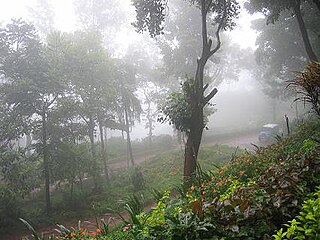
Mudigere is a Town and Taluk in Chikmagalur district in the Indian state of Karnataka. It is 30 km from the district headquarters.

Karnataka, the sixth largest state in India, has been ranked as the third most popular state in the country for tourism in 2014. It is home to 507 of the 3600 centrally protected monuments in India, second only to Uttar Pradesh. The State Directorate of Archaeology and Museums protects an additional 752 monuments and another 25,000 monuments are yet to receive protection.
Banakal is a Malnad town in Mudigere Taluk, Chikkamagaluru district of Karnataka, India. This town is situated atop the Charmadi hills in the Western Ghats section. The Western Ghats is one amongst twenty-five identified hot spots for biodiversity conservation in the world. Banakal is surrounded by coffee estates and paddy fields and known for its pleasant weather throughout the year. Banakal town is the headquarters of Banakal Hobli.

Ujire is a town near Dharmasthala. It is in Belthangady taluk of Dakshina Kannada district. Ujire is an important junction for travelers in this region. The road at Ujire deviates to Dharmasthala, Kottigehara and Belthangady.

Charmadi Ghat (Charmady) is a ghatti beginning from Belthangady taluk of Dakshina Kannada and ending in Mudigere taluk of Chikmagalur. It is one of the points in Western ghats through which motorable road passes connecting Dakshina Kannada with Chikmagalur district. The section of ghat is known by the name of Charmadi Ghat. It lies on National Highway 73 which connects Mangalore to Tumkur. The nearest places are Charmadi village, Ujire, Belthangady, Puttur, Kottigehara, Balur and Kalasa and Banakal.

Kottigehara is a village located atop the Charmadi ghat in Mudigere taluk of Chikkamagaluru district of Karnataka state, India. It is located 16 km from Mudigere town.The nearest railway stations are at Chikkamagaluru (47 km), Hassan (87 km) and Mangaluru (104 km) respectively. The nearest international airport is Mangalore International Airport. Kottigehara is located at an elevation of 962 m (3,156 ft) above Mean Sea Level.

Panch Kedar, rendered Pancha Kedara in Sanskrit, refers to five Hindu temples or holy places of the Shaivite sect dedicated to god Shiva. They are located in the Garhwal Himalayan region in Uttarakhand, India. They are the subject of many legends that directly link their creation to Pandavas, the heroes of the Indian epic Mahabharata.
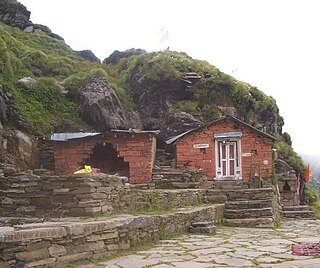
Rudranath Temple is a Hindu temple dedicated to God Shiva, located in the Garhwal Himalayan mountains in Uttarakhand, India. Located at 3,600 metres (11,800 ft) above sea level, this natural rock temple is situated within a dense forest of rhododendron dwarfs and Alpine pastures. The temple is the fourth temple to be visited in the Panch Kedar pilgrimage circuit, comprising five Shiva temples in the Garhwal region to be visited in a strict pecking order starting with Kedarnath at an altitude of 3,583 m, the Tungnath (तुंगनाथ)(3,680 m or 12,070 ft), Rudranath (रुद्रनाथ), Madhyamaheshwar (मध्यमहेश्वर) and Kalpeshwar (कल्पेश्वर).
Chikkamagaluru Lok Sabha Constituency was a former Lok Sabha (parliamentary) constituency in Karnataka state in southern India. With the implementation of the delimitation of parliamentary constituencies in 2008, it ceased to exist.
Mullayyanagiri is the highest peak in Karnataka, India. Mullayyanagiri is located in the Chandra Dhrona Hill Ranges of the Western Ghats of Chikkamagaluru Taluk. With a height of 1,925 metres (6,316 ft), it is the highest peak in Karnataka and also the 23rd highest peak in Western Ghats. The summit of Mullayanagiri has a small temple and houses a police radio relay station. Seethalayyanagiri is a prominent peak which is adjacent to this place.

The Keladi Shivappa NayakaUniversity of Agricultural and Horticultural Sciences, Shimoga(KSNUAHS) is a university in the Indian state of Karnataka. It is the state's first integrated university to have both agricultural and horticultural sciences under its purview.

College of Horticulture Mudigere is a horticulture college located in Mudigere, Karnataka, India. Established in 1991, it is affiliated to the University of Agricultural and Horticultural Sciences, Shivamogga and was previously affiliated to the University of Horticultural Sciences, Bagalkot. This horticultural education center is the oldest in Karnataka. The college has been accredited by the Indian Council of Agricultural Research since 25 August 2004.
Malahalli, Mudigere Talluk is a village located in Mudigere Talluk of Chikkamagaluru district, Karnataka, India. It is situated 15 km away from sub-district headquarter Mudigere and 26 km away from district headquarter Chikkamagaluru. As per 2009 census, Nandipura is the gram panchayat of Malahalli village. Nearest post office to Malahalli is Buskal, Pin code - 577132.


