Related Research Articles

Green Island, also known as North Brewster Island, is a rocky outer island in the Boston Harbor Islands National Recreation Area, to the north of Calf Island and Hypocrite Channel. The island has a permanent size of 2.5 acres (10,000 m2), plus an intertidal zone of a further 15 acres (61,000 m2), and is exposed from the east and northeast with little soil or plant life. The island is named after Joseph Green, a well-known merchant, who owned the island during Colonial times.

Ragged Island is an island in the Hingham Bay area of the Boston Harbor Islands National Recreation Area, in the U.S. state of Massachusetts. The island has a permanent size of 4 acres (16,000 m2), and it is composed of Roxbury puddingstone which rises to a height of 30 feet (9.1 m) above sea level. Broken ledges surround most of the island with small gravel beaches on the southeast and northwest sides; there are also small tidal mudflats.
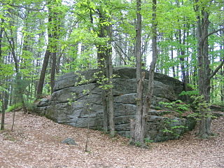
South Channel or Broad Sound South Entrance Channel is one of three shipping channels in the United States connecting Boston Harbor to Massachusetts Bay near Boston, Massachusetts. Starting at the eastern end of the President’s Roads anchorage, the channel passes north of Lovell's Island and Ram’s Head Flats, then northwest of Aldridge Ledge and the Devils Back. It is dredged to a 30-foot depth.
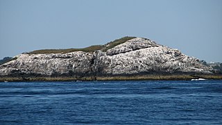
The Graves is an aggregation of rock outcroppings in Massachusetts Bay, Massachusetts, United States. Situated some 11 miles (18 km) offshore of downtown Boston, it is the outermost island in the Boston Harbor Islands National Recreation Area.

Bakers Island is a small, residential island in Massachusetts Bay, in Salem, Massachusetts. It is located southeast of Great Misery Island & Little Misery Island, northeast of North Gooseberry Island and South Gooseberry Island, and far northeast of Children's Island. It is the outermost island on the main shipping channel into Salem Harbor. Bakers Island Light, located on the island's northern side, is used for navigation.
Redemption Rock is a colonial-era historic site in Princeton, Massachusetts. In 1676, during King Philip's War, the release of Mary Rowlandson from her Native American captors was negotiated atop a granite ledge. The 0.25-acre (0.10 ha) parcel upon which the rock stands was acquired by the land conservation non-profit organization The Trustees of Reservations in 1953, and is open to the public.
Sarah Island is an island in the Hingham Bay area of the Boston Harbor Islands National Recreation Area. The island has a permanent size of just under 5 acres (20,000 m2), and is composed large outcroppings and ledges of Roxbury puddingstone together with glacial till which rises to a height of 30 feet (9.1 m) above sea level. The ledges, beaches and mudflats make the ideal nesting place for gulls.

The passenger steamer City of Columbus ran aground on Devil's Bridge off the Gay Head Cliffs in Aquinnah, Massachusetts, in the early hours of January 18, 1884. She was owned by Boston & Savannah Steamship Company and was built in 1878 by Delaware River Iron Ship Building and Engine Works, at Chester, Pennsylvania. City of Columbus made regular runs from Boston, Massachusetts to Savannah, Georgia.
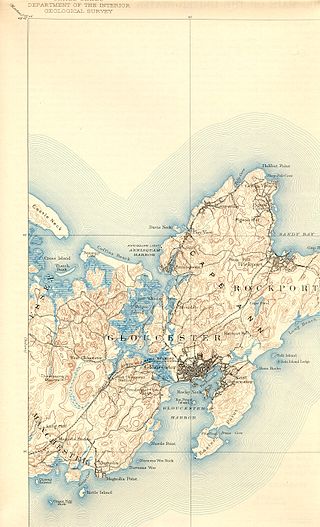
The Annisquam River is a tidal, salt-water estuary in the Annisquam neighborhood of Gloucester, Massachusetts, connecting Annisquam Harbor on the north to Gloucester Harbor on the south. The segment between Gloucester Harbor and the Newburyport/Rockport Line bridge is also known as the Blynman Canal.

Chapel Brook of Franklin County, Massachusetts is a tributary of the South River and the name of a 173-acre (70 ha) open space preserve located along the brook. The brook, est. 3.79 mi (6.10 km) long, is located in southeast Ashfield and southwest Conway. It drains into Poland Brook, thence into the South River, the Deerfield River, the Connecticut River, and Long Island Sound. The Chapel Brook reservation, managed by the non-profit conservation organization The Trustees of Reservations, is located in Ashfield and contains Chapel Falls, a series of three waterfalls on Chapel Brook, measuring 10 feet (3.0 m), 15 feet (4.6 m) and 20 feet (6.1 m) high; and Pony Mountain est. 1,400 feet (430 m), a 100-foot (30 m) open granite cliff face and popular recreational rock climbing site.

Tyringham Cobble is a 206-acre (83 ha) open space reservation located in Tyringham, Massachusetts on 411 m (1,348 ft) Cobble Hill in The Berkshires. It is managed by The Trustees of Reservations, a non-profit conservation organization, and is notable for its scenic views over the rural landscape of Tyringham Valley from rocky ledges and open fields. The reservation consists of the hill and surrounding agricultural and pasture land. In 2008, part of the 2,175 mile (3,500 km) Appalachian Trail was routed over the summit ledges.

The Warner Trail is a 30 mi (48 km) New England hiking trail which extends from Diamond Hill in the northeast corner of Rhode Island northeast through Norfolk County, Massachusetts to Canton, 13 miles (21 km) south of Boston.
Minot's Ledge, also known as the Cohasset Rocks, is a reef off the harbor of Cohasset, Massachusetts, 15 miles southeast of Boston, Massachusetts. It is the site of the Minot's Ledge Light, completed in 1860 and considered one of the most significant American engineering achievements of the 19th century. It was constructed by installing pins through tons of granite blocks into the rocks beneath to form the 40-foot base of the tower. The lighthouse is still operating. It is located within the Town of Scituate, in Plymouth County.

Elliott Laurel is a 33-acre (13 ha) open space preserve located in Phillipston, Massachusetts. The property, notable for its extensive stands of mountain laurel, is managed by the land conservation non-profit organization The Trustees of Reservations. Elliott Laurel also contains woodlands, ledges, boulders, and a hayfield.
Jacobs Hill is a 173-acre (70 ha) open space preserve in Royalston, Massachusetts acquired in 1975 by the land conservation non-profit organization The Trustees of Reservations. The preserve includes scenic vistas, ledges, woodlands, a northern bog, and Spirit Falls, a 30 foot (9.1 m) waterfall. The 22-mile (35 km) Tully Trail passes through the property. Views from the ledges include the Berkshires as well as nearby Long Pond and the Tully River Valley, Tully Mountain, and Mount Grace.

USRC Gallatin, was a Gallatin–class revenue cutter of the United States Revenue Cutter Service in commission from 1874 to 1892. The fourth ship of the Revenue Cutter Service to bear the name, she was named for the fourth U.S. Secretary of the Treasury, Albert Gallatin.
Egg Rock in Nahant Bay near Nahant, Massachusetts is a small island at 42.4333°N 70.8978°W. It was formerly the site of a lighthouse known as Egg Rock Light but now is owned by the state of Massachusetts as a bird sanctuary. Egg Rock can be seen clearly from the coasts of Nahant, Swampscott, and Lynn. Egg Rock is the setting for Sylvia Plath's poem "Suicide off Egg Rock", and also appears in her novel, The Bell Jar.
Harding's Ledge, also known as Harding Ledge, is a shoal in the Atlantic Ocean located on the approach to Boston Harbor, 1.5 miles east of Point Allerton, in Hull, Massachusetts, United States. The shoal is exposed at low tide and has been the site of numerous shipwrecks. A lighted bell buoy located 0.3 miles northeast guides boats around the outside of the shoal.
Castle Rock is a barren, uninhabited island located in Nahant Bay in Nahant, Massachusetts.
Marblehead Rock is an island off Marblehead, Massachusetts.
References
- ↑ "Devils Back". edits.nationalmap.gov. Geographic Names Information System.
| | This article about a location in Boston is a stub. You can help Wikipedia by expanding it. |